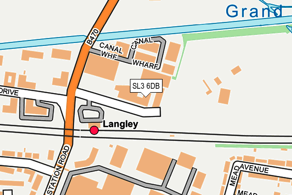
SL3 6DB is located in the Langley Meads electoral ward, within the unitary authority of Slough and the English Parliamentary constituency of Slough. The Sub Integrated Care Board (ICB) Location is NHS Frimley ICB - D4U1Y and the police force is Thames Valley. This postcode has been in use since January 1980.


GetTheData
Source: OS OpenMap – Local (Ordnance Survey)
Source: OS VectorMap District (Ordnance Survey)
Licence: Open Government Licence (requires attribution)
| Easting | 501398 |
| Northing | 179849 |
| Latitude | 51.508483 |
| Longitude | -0.540330 |
GetTheData
Source: Open Postcode Geo
Licence: Open Government Licence
| Country | England |
| Postcode District | SL3 |
| ➜ SL3 open data dashboard ➜ See where SL3 is on a map ➜ Where is Slough? | |
GetTheData
Source: Land Registry Price Paid Data
Licence: Open Government Licence
Elevation or altitude of SL3 6DB as distance above sea level:
| Metres | Feet | |
|---|---|---|
| Elevation | 30m | 98ft |
Elevation is measured from the approximate centre of the postcode, to the nearest point on an OS contour line from OS Terrain 50, which has contour spacing of ten vertical metres.
➜ How high above sea level am I? Find the elevation of your current position using your device's GPS.
GetTheData
Source: Open Postcode Elevation
Licence: Open Government Licence
| Ward | Langley Meads |
| Constituency | Slough |
GetTheData
Source: ONS Postcode Database
Licence: Open Government Licence
| June 2022 | Other theft | On or near Canal Wharf | 93m |
| June 2022 | Violence and sexual offences | On or near Canal Wharf | 93m |
| June 2022 | Violence and sexual offences | On or near Mead Walk | 289m |
| ➜ Get more crime data in our Crime section | |||
GetTheData
Source: data.police.uk
Licence: Open Government Licence
| Sawyers Green Farm (Langley Park Road) | Shreding Green | 247m |
| Langley Business Park (Station Road) | Langley | 281m |
| Sawyers Green Farm (Langley Park Road) | Shreding Green | 302m |
| Langley Business Park (Station Road) | Langley | 324m |
| Harrow Market (Station Road) | Langley | 501m |
| Langley (Berks) Station | 0.1km |
| Iver Station | 2.3km |
| Slough Station | 3.6km |
GetTheData
Source: NaPTAN
Licence: Open Government Licence
GetTheData
Source: ONS Postcode Database
Licence: Open Government Licence


➜ Get more ratings from the Food Standards Agency
GetTheData
Source: Food Standards Agency
Licence: FSA terms & conditions
| Last Collection | |||
|---|---|---|---|
| Location | Mon-Fri | Sat | Distance |
| Meadfield Road | 18:15 | 11:30 | 414m |
| High Street | 18:30 | 13:00 | 982m |
| Parlaunt Road Post Office | 18:00 | 13:00 | 1,008m |
GetTheData
Source: Dracos
Licence: Creative Commons Attribution-ShareAlike
| Facility | Distance |
|---|---|
| Absolutely Fitness @ Langley College Station Road, Langley, Slough Health and Fitness Gym, Sports Hall, Artificial Grass Pitch | 465m |
| The Langley Heritage Primary Kennett Road, Slough Grass Pitches | 683m |
| Iver Golf Club Hollow Hill Lane, Iver Golf | 708m |
GetTheData
Source: Active Places
Licence: Open Government Licence
| School | Phase of Education | Distance |
|---|---|---|
| Windsor Forest Colleges Group Station Road, Langley, Slough, SL3 8BY | 16 plus | 461m |
| Langley Hall Primary Academy Station Road, Langley, SL3 8GW | Primary | 562m |
| Langley Hall Arts Academy 4 Waterside Court, Waterside Drive, Langley, Berkshire, SL3 6EZ | Not applicable | 647m |
GetTheData
Source: Edubase
Licence: Open Government Licence
The below table lists the International Territorial Level (ITL) codes (formerly Nomenclature of Territorial Units for Statistics (NUTS) codes) and Local Administrative Units (LAU) codes for SL3 6DB:
| ITL 1 Code | Name |
|---|---|
| TLJ | South East (England) |
| ITL 2 Code | Name |
| TLJ1 | Berkshire, Buckinghamshire and Oxfordshire |
| ITL 3 Code | Name |
| TLJ11 | Berkshire |
| LAU 1 Code | Name |
| E06000039 | Slough |
GetTheData
Source: ONS Postcode Directory
Licence: Open Government Licence
The below table lists the Census Output Area (OA), Lower Layer Super Output Area (LSOA), and Middle Layer Super Output Area (MSOA) for SL3 6DB:
| Code | Name | |
|---|---|---|
| OA | E00083345 | |
| LSOA | E01016506 | Slough 010A |
| MSOA | E02003416 | Slough 010 |
GetTheData
Source: ONS Postcode Directory
Licence: Open Government Licence
| SL3 6EG | Canal Wharf | 80m |
| SL3 8HS | Mead Avenue | 240m |
| SL3 8HT | Mead Avenue | 288m |
| SL3 8BT | Station Road | 290m |
| SL3 8HU | Mead Walk | 299m |
| SL3 8DL | Alderbury Road | 330m |
| SL3 8LZ | Scholars Walk | 341m |
| SL3 8JA | Mead Avenue | 354m |
| SL3 8HP | Meadfield Avenue | 362m |
| SL3 8HX | Mead Close | 368m |
GetTheData
Source: Open Postcode Geo; Land Registry Price Paid Data
Licence: Open Government Licence