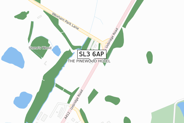
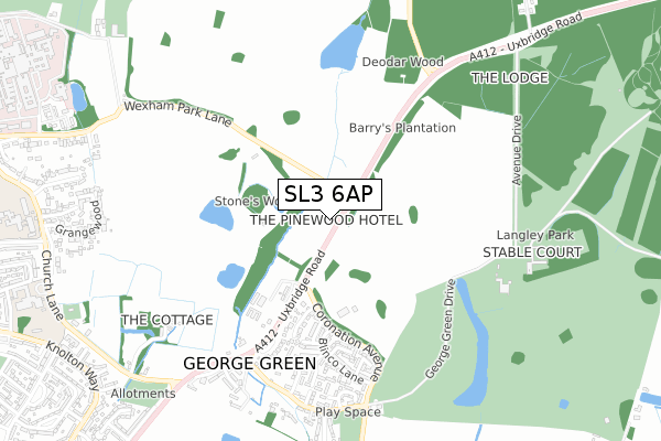
SL3 6AP is located in the Stoke Poges and Wexham electoral ward, within the unitary authority of Buckinghamshire and the English Parliamentary constituency of Beaconsfield. The Sub Integrated Care Board (ICB) Location is NHS Buckinghamshire, Oxfordshire and Berkshire West ICB - 14Y and the police force is Thames Valley. This postcode has been in use since January 1980.


GetTheData
Source: OS Open Zoomstack (Ordnance Survey)
Licence: Open Government Licence (requires attribution)
Attribution: Contains OS data © Crown copyright and database right 2024
Source: Open Postcode Geo
Licence: Open Government Licence (requires attribution)
Attribution: Contains OS data © Crown copyright and database right 2024; Contains Royal Mail data © Royal Mail copyright and database right 2024; Source: Office for National Statistics licensed under the Open Government Licence v.3.0
| Easting | 500248 |
| Northing | 181848 |
| Latitude | 51.526657 |
| Longitude | -0.556327 |
GetTheData
Source: Open Postcode Geo
Licence: Open Government Licence
| Country | England |
| Postcode District | SL3 |
| ➜ SL3 open data dashboard ➜ See where SL3 is on a map | |
GetTheData
Source: Land Registry Price Paid Data
Licence: Open Government Licence
Elevation or altitude of SL3 6AP as distance above sea level:
| Metres | Feet | |
|---|---|---|
| Elevation | 40m | 131ft |
Elevation is measured from the approximate centre of the postcode, to the nearest point on an OS contour line from OS Terrain 50, which has contour spacing of ten vertical metres.
➜ How high above sea level am I? Find the elevation of your current position using your device's GPS.
GetTheData
Source: Open Postcode Elevation
Licence: Open Government Licence
| Ward | Stoke Poges And Wexham |
| Constituency | Beaconsfield |
GetTheData
Source: ONS Postcode Database
Licence: Open Government Licence
| June 2022 | Violence and sexual offences | On or near Rixon Close | 387m |
| June 2022 | Violence and sexual offences | On or near Rixon Close | 387m |
| June 2022 | Criminal damage and arson | On or near Rixon Close | 387m |
| ➜ Get more crime data in our Crime section | |||
GetTheData
Source: data.police.uk
Licence: Open Government Licence
| Blinco Lane | George Green | 518m |
| Uxbridge Road | George Green | 630m |
| Uxbridge Road | George Green | 768m |
| Dawes Moor Close (Uxbridge Road) | Wexham Court | 1,014m |
| Welden (Church Lane) | Wexham Court | 1,024m |
| Langley (Berks) Station | 2.3km |
| Slough Station | 2.9km |
| Iver Station | 4km |
GetTheData
Source: NaPTAN
Licence: Open Government Licence
GetTheData
Source: ONS Postcode Database
Licence: Open Government Licence


➜ Get more ratings from the Food Standards Agency
GetTheData
Source: Food Standards Agency
Licence: FSA terms & conditions
| Last Collection | |||
|---|---|---|---|
| Location | Mon-Fri | Sat | Distance |
| Alan Way | 17:45 | 10:30 | 697m |
| Rowley Farm | 17:15 | 10:30 | 1,014m |
| Knolton Way | 18:00 | 10:45 | 1,331m |
GetTheData
Source: Dracos
Licence: Creative Commons Attribution-ShareAlike
| Facility | Distance |
|---|---|
| Harvey Memorial Recreation Ground George Green Road, George Green, Slough Grass Pitches | 737m |
| Wexham School Norway Drive, Slough Sports Hall, Grass Pitches, Artificial Grass Pitch, Studio, Outdoor Tennis Courts | 1.3km |
| Black Park Black Park Road, Wexham, Slough Cycling | 1.4km |
GetTheData
Source: Active Places
Licence: Open Government Licence
| School | Phase of Education | Distance |
|---|---|---|
| Wexham School Norway Drive, Slough, SL2 5QP | Secondary | 1.1km |
| Wexham Court Primary School Church Lane, Wexham, Slough, SL3 6LU | Primary | 1.2km |
| St Ethelbert's Catholic Primary School Wexham Road, Slough, SL2 5QR | Primary | 1.9km |
GetTheData
Source: Edubase
Licence: Open Government Licence
The below table lists the International Territorial Level (ITL) codes (formerly Nomenclature of Territorial Units for Statistics (NUTS) codes) and Local Administrative Units (LAU) codes for SL3 6AP:
| ITL 1 Code | Name |
|---|---|
| TLJ | South East (England) |
| ITL 2 Code | Name |
| TLJ1 | Berkshire, Buckinghamshire and Oxfordshire |
| ITL 3 Code | Name |
| TLJ13 | Buckinghamshire |
| LAU 1 Code | Name |
| E06000060 | Buckinghamshire |
GetTheData
Source: ONS Postcode Directory
Licence: Open Government Licence
The below table lists the Census Output Area (OA), Lower Layer Super Output Area (LSOA), and Middle Layer Super Output Area (MSOA) for SL3 6AP:
| Code | Name | |
|---|---|---|
| OA | E00089987 | |
| LSOA | E01017835 | South Bucks 005E |
| MSOA | E02003692 | South Bucks 005 |
GetTheData
Source: ONS Postcode Directory
Licence: Open Government Licence
| SL3 6RH | Rixon Close | 409m |
| SL3 6RP | August End | 439m |
| SL3 6RW | Diana Close | 504m |
| SL3 6AS | Uxbridge Road | 529m |
| SL3 6RQ | Blinco Lane | 541m |
| SL3 6RL | Azalea Way | 546m |
| SL3 6SA | Thorn Drive | 556m |
| SL3 6RN | Azalea Way | 564m |
| SL3 6AN | Uxbridge Road | 567m |
| SL3 6RG | Blinco Lane | 570m |
GetTheData
Source: Open Postcode Geo; Land Registry Price Paid Data
Licence: Open Government Licence