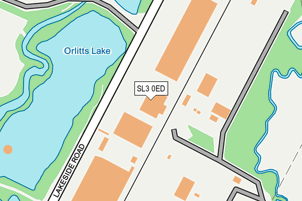
SL3 0ED is located in the Colnbrook & Poyle electoral ward, within the unitary authority of Slough and the English Parliamentary constituency of Windsor. The Sub Integrated Care Board (ICB) Location is NHS Frimley ICB - D4U1Y and the police force is Thames Valley. This postcode has been in use since January 1980.


GetTheData
Source: OS OpenMap – Local (Ordnance Survey)
Source: OS VectorMap District (Ordnance Survey)
Licence: Open Government Licence (requires attribution)
| Easting | 504065 |
| Northing | 177633 |
| Latitude | 51.488082 |
| Longitude | -0.502549 |
GetTheData
Source: Open Postcode Geo
Licence: Open Government Licence
| Country | England |
| Postcode District | SL3 |
| ➜ SL3 open data dashboard ➜ See where SL3 is on a map | |
GetTheData
Source: Land Registry Price Paid Data
Licence: Open Government Licence
Elevation or altitude of SL3 0ED as distance above sea level:
| Metres | Feet | |
|---|---|---|
| Elevation | 30m | 98ft |
Elevation is measured from the approximate centre of the postcode, to the nearest point on an OS contour line from OS Terrain 50, which has contour spacing of ten vertical metres.
➜ How high above sea level am I? Find the elevation of your current position using your device's GPS.
GetTheData
Source: Open Postcode Elevation
Licence: Open Government Licence
| Ward | Colnbrook & Poyle |
| Constituency | Windsor |
GetTheData
Source: ONS Postcode Database
Licence: Open Government Licence
| January 2024 | Other theft | On or near Park/Open Space | 312m |
| January 2024 | Criminal damage and arson | On or near Park/Open Space | 312m |
| November 2023 | Vehicle crime | On or near Park/Open Space | 312m |
| ➜ Get more crime data in our Crime section | |||
GetTheData
Source: data.police.uk
Licence: Open Government Licence
| Lakeside Road (Colnbrook By Pass) | Colnbrook | 755m |
| Lakeside Road (Colnbrook By Pass) | Colnbrook | 806m |
| Speedbird Way | Harmondsworth | 977m |
| Moor Bridge | Longford | 1,020m |
| Moor Bridge | Longford | 1,059m |
| Heathrow Airport Terminal 5 | 2.1km |
| Heathrow Terminal 5 Station | 2.2km |
| Iver Station | 2.3km |
GetTheData
Source: NaPTAN
Licence: Open Government Licence
| Median download speed | 8.1Mbps |
| Average download speed | 8.5Mbps |
| Maximum download speed | 16.97Mbps |
| Median upload speed | 1.1Mbps |
| Average upload speed | 0.9Mbps |
| Maximum upload speed | 1.23Mbps |
GetTheData
Source: Ofcom
Licence: Ofcom Terms of Use (requires attribution)
GetTheData
Source: ONS Postcode Database
Licence: Open Government Licence


➜ Get more ratings from the Food Standards Agency
GetTheData
Source: Food Standards Agency
Licence: FSA terms & conditions
| Last Collection | |||
|---|---|---|---|
| Location | Mon-Fri | Sat | Distance |
| British Airways | 18:45 | 12:15 | 1,124m |
| Harmondsworth Post Office | 18:45 | 12:00 | 1,662m |
| Blackthorne Road | 18:30 | 1,927m | |
GetTheData
Source: Dracos
Licence: Creative Commons Attribution-ShareAlike
| Facility | Distance |
|---|---|
| Springhealth Leisure Club (Heathrow) (Closed) Bath Road, Longford Swimming Pool, Health and Fitness Gym, Studio | 1.5km |
| Imagine Health And Spa (Thames Valley) Poyle Road, Colnbrook, Slough Health and Fitness Gym | 1.5km |
| Colnbrook Church Of England Primary School High Street, Colnbrook, Slough Grass Pitches | 1.6km |
GetTheData
Source: Active Places
Licence: Open Government Licence
| School | Phase of Education | Distance |
|---|---|---|
| Pippins School Raymond Close, Colnbrook, SL3 0PR | Primary | 934m |
| Colnbrook Church of England Primary School High Street, Colnbrook, SL3 0JZ | Primary | 1.6km |
| Harmondsworth Primary School School Road, Harmondsworth, West Drayton, UB7 0AU | Primary | 1.6km |
GetTheData
Source: Edubase
Licence: Open Government Licence
The below table lists the International Territorial Level (ITL) codes (formerly Nomenclature of Territorial Units for Statistics (NUTS) codes) and Local Administrative Units (LAU) codes for SL3 0ED:
| ITL 1 Code | Name |
|---|---|
| TLJ | South East (England) |
| ITL 2 Code | Name |
| TLJ1 | Berkshire, Buckinghamshire and Oxfordshire |
| ITL 3 Code | Name |
| TLJ11 | Berkshire |
| LAU 1 Code | Name |
| E06000039 | Slough |
GetTheData
Source: ONS Postcode Directory
Licence: Open Government Licence
The below table lists the Census Output Area (OA), Lower Layer Super Output Area (LSOA), and Middle Layer Super Output Area (MSOA) for SL3 0ED:
| Code | Name | |
|---|---|---|
| OA | E00083228 | |
| LSOA | E01016482 | Slough 014D |
| MSOA | E02003420 | Slough 014 |
GetTheData
Source: ONS Postcode Directory
Licence: Open Government Licence
| SL3 0EH | Colnbrook By Pass | 745m |
| SL3 0NJ | Old Bath Road | 784m |
| SL3 0EN | Galleymead Road | 894m |
| SL3 0QW | The Hawthorns | 901m |
| SL3 0PR | Raymond Close | 965m |
| SL3 0PP | Raymond Close | 989m |
| SL3 0PT | Winchester Close | 1004m |
| SL3 0PS | Winchester Close | 1023m |
| SL3 0PW | Daventry Close | 1034m |
| SL3 0PN | Rodney Way | 1055m |
GetTheData
Source: Open Postcode Geo; Land Registry Price Paid Data
Licence: Open Government Licence