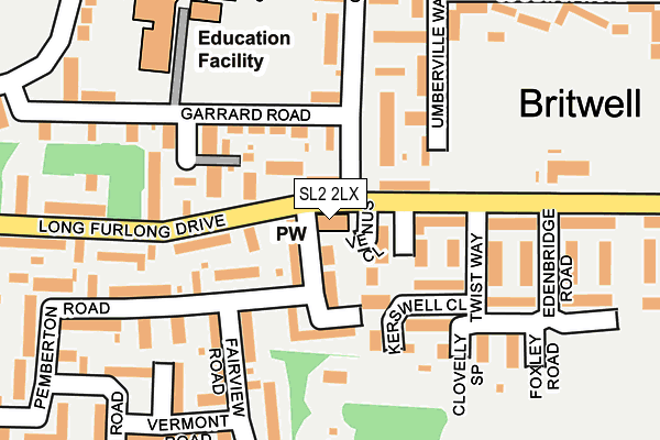
SL2 2LX is located in the Northborough & Lynch Hill Valley electoral ward, within the unitary authority of Slough and the English Parliamentary constituency of Slough. The Sub Integrated Care Board (ICB) Location is NHS Frimley ICB - D4U1Y and the police force is Thames Valley. This postcode has been in use since January 1980.


GetTheData
Source: OS OpenMap – Local (Ordnance Survey)
Source: OS VectorMap District (Ordnance Survey)
Licence: Open Government Licence (requires attribution)
| Easting | 494678 |
| Northing | 182346 |
| Latitude | 51.532093 |
| Longitude | -0.636460 |
GetTheData
Source: Open Postcode Geo
Licence: Open Government Licence
| Country | England |
| Postcode District | SL2 |
| ➜ SL2 open data dashboard ➜ See where SL2 is on a map ➜ Where is Slough? | |
GetTheData
Source: Land Registry Price Paid Data
Licence: Open Government Licence
Elevation or altitude of SL2 2LX as distance above sea level:
| Metres | Feet | |
|---|---|---|
| Elevation | 40m | 131ft |
Elevation is measured from the approximate centre of the postcode, to the nearest point on an OS contour line from OS Terrain 50, which has contour spacing of ten vertical metres.
➜ How high above sea level am I? Find the elevation of your current position using your device's GPS.
GetTheData
Source: Open Postcode Elevation
Licence: Open Government Licence
| Ward | Northborough & Lynch Hill Valley |
| Constituency | Slough |
GetTheData
Source: ONS Postcode Database
Licence: Open Government Licence
| January 2024 | Criminal damage and arson | On or near Cecil Way | 142m |
| January 2024 | Vehicle crime | On or near Cecil Way | 142m |
| January 2024 | Drugs | On or near Northmead Road | 355m |
| ➜ Get more crime data in our Crime section | |||
GetTheData
Source: data.police.uk
Licence: Open Government Licence
| St Georges Church (Long Furlong Drive) | Britwell | 43m |
| St Georges Church (Long Furlong Drive) | Britwell | 81m |
| Fairview Road (Whittaker Road) | Britwell | 274m |
| Lynch Pin Ph (Long Furlong Drive) | Britwell | 297m |
| Fairview Road (Whittaker Road) | Britwell | 300m |
| Burnham (Berks) Station | 1.2km |
| Taplow Station | 3.3km |
| Slough Station | 3.8km |
GetTheData
Source: NaPTAN
Licence: Open Government Licence
GetTheData
Source: ONS Postcode Database
Licence: Open Government Licence


➜ Get more ratings from the Food Standards Agency
GetTheData
Source: Food Standards Agency
Licence: FSA terms & conditions
| Last Collection | |||
|---|---|---|---|
| Location | Mon-Fri | Sat | Distance |
| Long Furlong (Pemberton) | 18:15 | 12:30 | 48m |
| Gaveston Road | 18:30 | 10:30 | 324m |
| Marescroft Road | 18:15 | 10:30 | 439m |
GetTheData
Source: Dracos
Licence: Creative Commons Attribution-ShareAlike
| Facility | Distance |
|---|---|
| Britwell Community Centre Long Furlong Drive, Slough Grass Pitches | 219m |
| Lynch Hill School Primary Academy Garrard Road, Slough Grass Pitches | 255m |
| Haybrook College Burnham Lane, Slough Sports Hall, Artificial Grass Pitch | 899m |
GetTheData
Source: Active Places
Licence: Open Government Licence
| School | Phase of Education | Distance |
|---|---|---|
| Lynch Hill School Primary Academy Garrard Road, Slough, SL2 2AN | Primary | 255m |
| Claycots School Monksfield Way, Slough, SL2 1QX | Primary | 827m |
| Haybrook College 112 Burnham Lane, Slough, SL1 6LZ | Not applicable | 939m |
GetTheData
Source: Edubase
Licence: Open Government Licence
The below table lists the International Territorial Level (ITL) codes (formerly Nomenclature of Territorial Units for Statistics (NUTS) codes) and Local Administrative Units (LAU) codes for SL2 2LX:
| ITL 1 Code | Name |
|---|---|
| TLJ | South East (England) |
| ITL 2 Code | Name |
| TLJ1 | Berkshire, Buckinghamshire and Oxfordshire |
| ITL 3 Code | Name |
| TLJ11 | Berkshire |
| LAU 1 Code | Name |
| E06000039 | Slough |
GetTheData
Source: ONS Postcode Directory
Licence: Open Government Licence
The below table lists the Census Output Area (OA), Lower Layer Super Output Area (LSOA), and Middle Layer Super Output Area (MSOA) for SL2 2LX:
| Code | Name | |
|---|---|---|
| OA | E00083081 | |
| LSOA | E01016455 | Slough 001F |
| MSOA | E02003407 | Slough 001 |
GetTheData
Source: ONS Postcode Directory
Licence: Open Government Licence
| SL2 2JD | Pemberton Road | 47m |
| SL2 2PL | Venus Close | 51m |
| SL2 2JE | Pemberton Road | 64m |
| SL2 2PJ | Long Furlong Drive | 76m |
| SL2 2HZ | Calbroke Road | 77m |
| SL2 2JB | Coombe Close | 84m |
| SL2 2PH | Long Furlong Drive | 87m |
| SL2 2JQ | Pemberton Road | 104m |
| SL2 2HA | Calbroke Road | 106m |
| SL2 2QH | Kerswell Close | 119m |
GetTheData
Source: Open Postcode Geo; Land Registry Price Paid Data
Licence: Open Government Licence