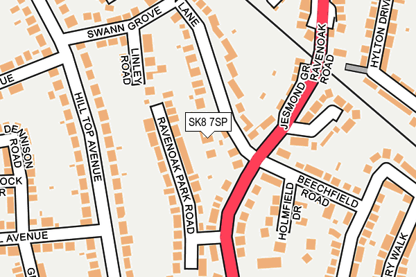
SK8 7SP lies on Lyme Lea Close in Cheadle Hulme, Cheadle. SK8 7SP is located in the Cheadle Hulme South electoral ward, within the metropolitan district of Stockport and the English Parliamentary constituency of Cheadle. The Sub Integrated Care Board (ICB) Location is NHS Greater Manchester ICB - 01W and the police force is Greater Manchester. This postcode has been in use since July 2002.


GetTheData
Source: OS OpenMap – Local (Ordnance Survey)
Source: OS VectorMap District (Ordnance Survey)
Licence: Open Government Licence (requires attribution)
| Easting | 387804 |
| Northing | 385854 |
| Latitude | 53.369407 |
| Longitude | -2.184757 |
GetTheData
Source: Open Postcode Geo
Licence: Open Government Licence
| Street | Lyme Lea Close |
| Locality | Cheadle Hulme |
| Town/City | Cheadle |
| Country | England |
| Postcode District | SK8 |
➜ See where SK8 is on a map ➜ Where is Cheadle Hulme? | |
GetTheData
Source: Land Registry Price Paid Data
Licence: Open Government Licence
Elevation or altitude of SK8 7SP as distance above sea level:
| Metres | Feet | |
|---|---|---|
| Elevation | 70m | 230ft |
Elevation is measured from the approximate centre of the postcode, to the nearest point on an OS contour line from OS Terrain 50, which has contour spacing of ten vertical metres.
➜ How high above sea level am I? Find the elevation of your current position using your device's GPS.
GetTheData
Source: Open Postcode Elevation
Licence: Open Government Licence
| Ward | Cheadle Hulme South |
| Constituency | Cheadle |
GetTheData
Source: ONS Postcode Database
Licence: Open Government Licence
4, LYME LEA CLOSE, CHEADLE HULME, CHEADLE, SK8 7SP 2019 18 JAN £775,000 |
2017 27 OCT £625,000 |
4, LYME LEA CLOSE, CHEADLE HULME, CHEADLE, SK8 7SP 2002 31 JUL £465,000 |
1, LYME LEA CLOSE, CHEADLE HULME, CHEADLE, SK8 7SP 2002 26 JUL £325,000 |
2002 10 JUL £295,000 |
2, LYME LEA CLOSE, CHEADLE HULME, CHEADLE, SK8 7SP 2002 9 JUL £313,000 |
GetTheData
Source: HM Land Registry Price Paid Data
Licence: Contains HM Land Registry data © Crown copyright and database right 2025. This data is licensed under the Open Government Licence v3.0.
| Ravenoak Rd/Swann Ln (Ravenoak Rd) | Cheadle Hulme | 82m |
| Ravenoak Rd/Swann Ln (Ravenoak Rd) | Cheadle Hulme | 98m |
| Ravenoak Rd/Church Inn (Ravenoak Rd) | Cheadle Hulme | 194m |
| Church Rd/Church Inn (Church Rd) | Cheadle Hulme | 270m |
| Ravenoak Rd/Manor Rd (Ravenoak Rd) | Cheadle Hulme | 273m |
| Cheadle Hulme Station | 0.8km |
| Bramhall Station | 1.7km |
| Davenport Station | 3.2km |
GetTheData
Source: NaPTAN
Licence: Open Government Licence
| Percentage of properties with Next Generation Access | 100.0% |
| Percentage of properties with Superfast Broadband | 100.0% |
| Percentage of properties with Ultrafast Broadband | 0.0% |
| Percentage of properties with Full Fibre Broadband | 0.0% |
Superfast Broadband is between 30Mbps and 300Mbps
Ultrafast Broadband is > 300Mbps
| Percentage of properties unable to receive 2Mbps | 0.0% |
| Percentage of properties unable to receive 5Mbps | 0.0% |
| Percentage of properties unable to receive 10Mbps | 0.0% |
| Percentage of properties unable to receive 30Mbps | 0.0% |
GetTheData
Source: Ofcom
Licence: Ofcom Terms of Use (requires attribution)
GetTheData
Source: ONS Postcode Database
Licence: Open Government Licence


➜ Get more ratings from the Food Standards Agency
GetTheData
Source: Food Standards Agency
Licence: FSA terms & conditions
| Last Collection | |||
|---|---|---|---|
| Location | Mon-Fri | Sat | Distance |
| Raven Oak Park Road | 17:30 | 11:30 | 145m |
| Hilltop Avenue | 17:30 | 11:30 | 250m |
| Station Road | 17:30 | 11:30 | 373m |
GetTheData
Source: Dracos
Licence: Creative Commons Attribution-ShareAlike
The below table lists the International Territorial Level (ITL) codes (formerly Nomenclature of Territorial Units for Statistics (NUTS) codes) and Local Administrative Units (LAU) codes for SK8 7SP:
| ITL 1 Code | Name |
|---|---|
| TLD | North West (England) |
| ITL 2 Code | Name |
| TLD3 | Greater Manchester |
| ITL 3 Code | Name |
| TLD35 | Greater Manchester South East |
| LAU 1 Code | Name |
| E08000007 | Stockport |
GetTheData
Source: ONS Postcode Directory
Licence: Open Government Licence
The below table lists the Census Output Area (OA), Lower Layer Super Output Area (LSOA), and Middle Layer Super Output Area (MSOA) for SK8 7SP:
| Code | Name | |
|---|---|---|
| OA | E00029322 | |
| LSOA | E01005789 | Stockport 039A |
| MSOA | E02001225 | Stockport 039 |
GetTheData
Source: ONS Postcode Directory
Licence: Open Government Licence
| SK8 7DW | Ravenoak Road | 91m |
| SK8 7EH | Ravenoak Park Road | 101m |
| SK8 7EG | Ravenoak Road | 118m |
| SK8 7HU | Swann Lane | 122m |
| SK8 7HP | Linley Road | 138m |
| SK8 7HZ | Hill Top Avenue | 145m |
| SK8 7DR | Jesmond Grove | 151m |
| SK8 7DZ | Ravenswood Drive | 173m |
| SK8 7DS | Beechfield Road | 183m |
| SK8 7DT | Holmfield Drive | 184m |
GetTheData
Source: Open Postcode Geo; Land Registry Price Paid Data
Licence: Open Government Licence