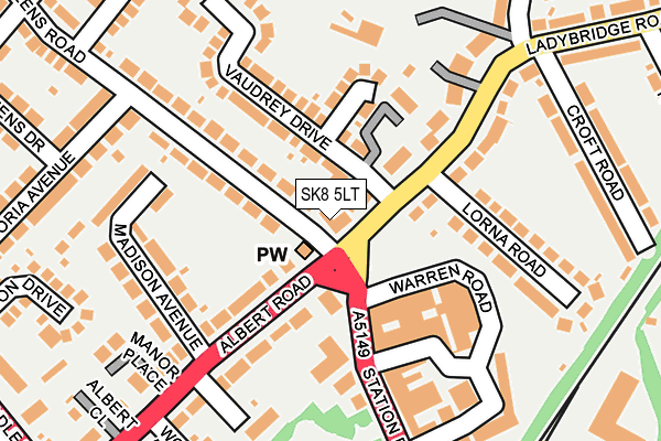
SK8 5LT lies on Albert Road in Cheadle Hulme, Cheadle. SK8 5LT is located in the Cheadle Hulme South electoral ward, within the metropolitan district of Stockport and the English Parliamentary constituency of Cheadle. The Sub Integrated Care Board (ICB) Location is NHS Greater Manchester ICB - 01W and the police force is Greater Manchester. This postcode has been in use since August 1993.


GetTheData
Source: OS OpenMap – Local (Ordnance Survey)
Source: OS VectorMap District (Ordnance Survey)
Licence: Open Government Licence (requires attribution)
| Easting | 387440 |
| Northing | 386887 |
| Latitude | 53.378700 |
| Longitude | -2.190268 |
GetTheData
Source: Open Postcode Geo
Licence: Open Government Licence
| Street | Albert Road |
| Locality | Cheadle Hulme |
| Town/City | Cheadle |
| Country | England |
| Postcode District | SK8 |
| ➜ SK8 open data dashboard ➜ See where SK8 is on a map ➜ Where is Cheadle Hulme? | |
GetTheData
Source: Land Registry Price Paid Data
Licence: Open Government Licence
Elevation or altitude of SK8 5LT as distance above sea level:
| Metres | Feet | |
|---|---|---|
| Elevation | 60m | 197ft |
Elevation is measured from the approximate centre of the postcode, to the nearest point on an OS contour line from OS Terrain 50, which has contour spacing of ten vertical metres.
➜ How high above sea level am I? Find the elevation of your current position using your device's GPS.
GetTheData
Source: Open Postcode Elevation
Licence: Open Government Licence
| Ward | Cheadle Hulme South |
| Constituency | Cheadle |
GetTheData
Source: ONS Postcode Database
Licence: Open Government Licence
| April 2021 | Violence and sexual offences | On or near Queens Road | 223m |
| ➜ Albert Road crime map and outcomes | |||
GetTheData
Source: data.police.uk
Licence: Open Government Licence
| Ladybridge Rd/Station Rd (Ladybridge Rd) | Cheadle Hulme | 58m |
| Ladybridge Rd/Station Rd (Ladybridge Rd) | Cheadle Hulme | 72m |
| Albert Rd/Station Rd (Albert Rd) | Cheadle Hulme | 155m |
| Station Rd/Cheadle Hulme Stn (Station Rd) | Cheadle Hulme | 189m |
| Station Rd/Cheadle Hulme Stn (Station Rd) | Cheadle Hulme | 228m |
| Cheadle Hulme Station | 0.3km |
| Bramhall Station | 2.7km |
| Davenport Station | 2.8km |
GetTheData
Source: NaPTAN
Licence: Open Government Licence
| Percentage of properties with Next Generation Access | 100.0% |
| Percentage of properties with Superfast Broadband | 100.0% |
| Percentage of properties with Ultrafast Broadband | 100.0% |
| Percentage of properties with Full Fibre Broadband | 0.0% |
Superfast Broadband is between 30Mbps and 300Mbps
Ultrafast Broadband is > 300Mbps
| Percentage of properties unable to receive 2Mbps | 0.0% |
| Percentage of properties unable to receive 5Mbps | 0.0% |
| Percentage of properties unable to receive 10Mbps | 0.0% |
| Percentage of properties unable to receive 30Mbps | 0.0% |
GetTheData
Source: Ofcom
Licence: Ofcom Terms of Use (requires attribution)
GetTheData
Source: ONS Postcode Database
Licence: Open Government Licence


➜ Get more ratings from the Food Standards Agency
GetTheData
Source: Food Standards Agency
Licence: FSA terms & conditions
| Last Collection | |||
|---|---|---|---|
| Location | Mon-Fri | Sat | Distance |
| Ladybridge Road | 17:30 | 11:30 | 16m |
| Warren Road | 17:30 | 11:30 | 220m |
| 11 Warren Road | 18:30 | 222m | |
GetTheData
Source: Dracos
Licence: Creative Commons Attribution-ShareAlike
| Facility | Distance |
|---|---|
| Cheadle Hulme Ladybridge Sports And Social Club Ladybridge Road, Cheadle Hulme, Cheadle Grass Pitches | 200m |
| Bridgehall Playing Fields Europa Way, Cheadle Hulme, Cheadle Grass Pitches | 538m |
| Sandringham Road Playing Fields Sandringham Road, Cheadle Hulme, Cheadle Grass Pitches | 553m |
GetTheData
Source: Active Places
Licence: Open Government Licence
| School | Phase of Education | Distance |
|---|---|---|
| Oak Tree Primary School Queens Road, Cheadle Hulme, Cheadle, Stockport, SK8 5HH | Primary | 437m |
| Lane End Primary School Ramillies Avenue, Cheadle Hulme, Stockport, SK8 7AL | Primary | 790m |
| Greenbank Preparatory School Heathbank Road, Cheadle Hulme, Cheadle, SK8 6HU | Not applicable | 895m |
GetTheData
Source: Edubase
Licence: Open Government Licence
The below table lists the International Territorial Level (ITL) codes (formerly Nomenclature of Territorial Units for Statistics (NUTS) codes) and Local Administrative Units (LAU) codes for SK8 5LT:
| ITL 1 Code | Name |
|---|---|
| TLD | North West (England) |
| ITL 2 Code | Name |
| TLD3 | Greater Manchester |
| ITL 3 Code | Name |
| TLD35 | Greater Manchester South East |
| LAU 1 Code | Name |
| E08000007 | Stockport |
GetTheData
Source: ONS Postcode Directory
Licence: Open Government Licence
The below table lists the Census Output Area (OA), Lower Layer Super Output Area (LSOA), and Middle Layer Super Output Area (MSOA) for SK8 5LT:
| Code | Name | |
|---|---|---|
| OA | E00029273 | |
| LSOA | E01005786 | Stockport 030E |
| MSOA | E02001216 | Stockport 030 |
GetTheData
Source: ONS Postcode Directory
Licence: Open Government Licence
| SK8 5LW | Arran Court | 64m |
| SK8 5LX | Bridgecrest Court | 64m |
| SK8 5NP | Arran Court | 104m |
| SK8 5LL | Ladybridge Road | 104m |
| SK8 5HG | Queens Road | 115m |
| SK8 5LS | Woodthorpe Drive | 118m |
| SK8 5LN | Roger Hay | 120m |
| SK8 5LU | Queens Road | 144m |
| SK8 5LR | Vaudrey Drive | 155m |
| SK8 5AE | Station Road | 165m |
GetTheData
Source: Open Postcode Geo; Land Registry Price Paid Data
Licence: Open Government Licence