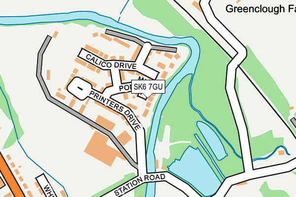
SK6 7GU lies on Mill Pond Close in Strines, Stockport. SK6 7GU is located in the Marple South & High Lane electoral ward, within the metropolitan district of Stockport and the English Parliamentary constituency of Hazel Grove. The Sub Integrated Care Board (ICB) Location is NHS Greater Manchester ICB - 01W and the police force is Greater Manchester. This postcode has been in use since December 2012.


GetTheData
Source: OS OpenMap – Local (Ordnance Survey)
Source: OS VectorMap District (Ordnance Survey)
Licence: Open Government Licence (requires attribution)
| Easting | 397521 |
| Northing | 386589 |
| Latitude | 53.376167 |
| Longitude | -2.038726 |
GetTheData
Source: Open Postcode Geo
Licence: Open Government Licence
| Street | Mill Pond Close |
| Locality | Strines |
| Town/City | Stockport |
| Country | England |
| Postcode District | SK6 |
➜ See where SK6 is on a map ➜ Where is Strines? | |
GetTheData
Source: Land Registry Price Paid Data
Licence: Open Government Licence
Elevation or altitude of SK6 7GU as distance above sea level:
| Metres | Feet | |
|---|---|---|
| Elevation | 100m | 328ft |
Elevation is measured from the approximate centre of the postcode, to the nearest point on an OS contour line from OS Terrain 50, which has contour spacing of ten vertical metres.
➜ How high above sea level am I? Find the elevation of your current position using your device's GPS.
GetTheData
Source: Open Postcode Elevation
Licence: Open Government Licence
| Ward | Marple South & High Lane |
| Constituency | Hazel Grove |
GetTheData
Source: ONS Postcode Database
Licence: Open Government Licence
| Strines Rd/Station Rd (Strines Rd) | Strines | 327m |
| Strines Rd/Station Rd (Strines Rd) | Strines | 349m |
| Strines Rd/Royal Oak (Strines Rd) | Strines | 430m |
| Strines Rd/Royal Oak (Strines Rd) | Strines | 457m |
| Strines Rd/Sportsmans Arms (Strines Rd) | Strines | 558m |
| Strines Station | 0.3km |
| Disley Station | 2km |
| New Mills Central Station | 2.5km |
GetTheData
Source: NaPTAN
Licence: Open Government Licence
| Percentage of properties with Next Generation Access | 0.0% |
| Percentage of properties with Superfast Broadband | 0.0% |
| Percentage of properties with Ultrafast Broadband | 0.0% |
| Percentage of properties with Full Fibre Broadband | 0.0% |
Superfast Broadband is between 30Mbps and 300Mbps
Ultrafast Broadband is > 300Mbps
| Median download speed | 4.0Mbps |
| Average download speed | 3.9Mbps |
| Maximum download speed | 4.88Mbps |
| Median upload speed | 0.8Mbps |
| Average upload speed | 0.7Mbps |
| Maximum upload speed | 0.96Mbps |
| Percentage of properties unable to receive 2Mbps | 0.0% |
| Percentage of properties unable to receive 5Mbps | 100.0% |
| Percentage of properties unable to receive 10Mbps | 100.0% |
| Percentage of properties unable to receive 30Mbps | 100.0% |
GetTheData
Source: Ofcom
Licence: Ofcom Terms of Use (requires attribution)
Estimated total energy consumption in SK6 7GU by fuel type, 2015.
| Consumption (kWh) | 56,214 |
|---|---|
| Meter count | 9 |
| Mean (kWh/meter) | 6,246 |
| Median (kWh/meter) | 5,196 |
| Consumption (kWh) | 12,971 |
|---|---|
| Meter count | 7 |
| Mean (kWh/meter) | 1,853 |
| Median (kWh/meter) | 1,707 |
GetTheData
Source: Postcode level gas estimates: 2015 (experimental)
Source: Postcode level electricity estimates: 2015 (experimental)
Licence: Open Government Licence
GetTheData
Source: ONS Postcode Database
Licence: Open Government Licence


➜ Get more ratings from the Food Standards Agency
GetTheData
Source: Food Standards Agency
Licence: FSA terms & conditions
| Last Collection | |||
|---|---|---|---|
| Location | Mon-Fri | Sat | Distance |
| Strines Road | 18:15 | 11:30 | 331m |
| Alma Terrace | 17:00 | 11:30 | 494m |
| Plucksbridge | 18:15 | 11:30 | 933m |
GetTheData
Source: Dracos
Licence: Creative Commons Attribution-ShareAlike
| Risk of SK6 7GU flooding from rivers and sea | Medium |
| ➜ SK6 7GU flood map | |
GetTheData
Source: Open Flood Risk by Postcode
Licence: Open Government Licence
The below table lists the International Territorial Level (ITL) codes (formerly Nomenclature of Territorial Units for Statistics (NUTS) codes) and Local Administrative Units (LAU) codes for SK6 7GU:
| ITL 1 Code | Name |
|---|---|
| TLD | North West (England) |
| ITL 2 Code | Name |
| TLD3 | Greater Manchester |
| ITL 3 Code | Name |
| TLD35 | Greater Manchester South East |
| LAU 1 Code | Name |
| E08000007 | Stockport |
GetTheData
Source: ONS Postcode Directory
Licence: Open Government Licence
The below table lists the Census Output Area (OA), Lower Layer Super Output Area (LSOA), and Middle Layer Super Output Area (MSOA) for SK6 7GU:
| Code | Name | |
|---|---|---|
| OA | E00029923 | |
| LSOA | E01005908 | Stockport 017D |
| MSOA | E02001203 | Stockport 017 |
GetTheData
Source: ONS Postcode Directory
Licence: Open Government Licence
| SK6 7GS | Calico Drive | 85m |
| SK6 7GX | Dovecote Road | 103m |
| SK6 7GT | Printers Drive | 109m |
| SK6 7GH | Pavilion Lane | 111m |
| SK6 7GG | Station Road | 258m |
| SK6 7GF | Whitecroft Road | 292m |
| SK6 7GD | Strines Road | 306m |
| SK22 3AH | Station Road | 314m |
| SK22 3AL | Strines | 318m |
| SK6 7GB | Strines Road | 355m |
GetTheData
Source: Open Postcode Geo; Land Registry Price Paid Data
Licence: Open Government Licence