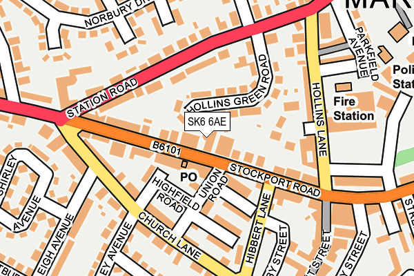
SK6 6AE is located in the Marple North electoral ward, within the metropolitan district of Stockport and the English Parliamentary constituency of Hazel Grove. The Sub Integrated Care Board (ICB) Location is NHS Greater Manchester ICB - 01W and the police force is Greater Manchester. This postcode has been in use since January 1980.


GetTheData
Source: OS OpenMap – Local (Ordnance Survey)
Source: OS VectorMap District (Ordnance Survey)
Licence: Open Government Licence (requires attribution)
| Easting | 395701 |
| Northing | 388714 |
| Latitude | 53.395239 |
| Longitude | -2.066113 |
GetTheData
Source: Open Postcode Geo
Licence: Open Government Licence
| Country | England |
| Postcode District | SK6 |
| ➜ SK6 open data dashboard ➜ See where SK6 is on a map ➜ Where is Marple? | |
GetTheData
Source: Land Registry Price Paid Data
Licence: Open Government Licence
Elevation or altitude of SK6 6AE as distance above sea level:
| Metres | Feet | |
|---|---|---|
| Elevation | 140m | 459ft |
Elevation is measured from the approximate centre of the postcode, to the nearest point on an OS contour line from OS Terrain 50, which has contour spacing of ten vertical metres.
➜ How high above sea level am I? Find the elevation of your current position using your device's GPS.
GetTheData
Source: Open Postcode Elevation
Licence: Open Government Licence
| Ward | Marple North |
| Constituency | Hazel Grove |
GetTheData
Source: ONS Postcode Database
Licence: Open Government Licence
| May 2022 | Public order | On or near John Street | 442m |
| April 2021 | Violence and sexual offences | On or near John Street | 442m |
| ➜ Get more crime data in our Crime section | |||
GetTheData
Source: data.police.uk
Licence: Open Government Licence
| Stockport Rd/Marple Swimming Pool (Stockport Rd) | Marple | 43m |
| Stockport Rd/Marple P.o. (Stockport Rd) | Marple | 63m |
| Hibbert Ln/Priory House (Hibbert Ln) | Marple | 170m |
| Hibbert Ln/Priory House (Hibbert Ln) | Marple | 180m |
| Stockport Rd/Navigation (Stockport Rd) | Marple | 227m |
| Rose Hill Marple Station | 0.7km |
| Marple Station | 0.8km |
| Romiley Station | 2.6km |
GetTheData
Source: NaPTAN
Licence: Open Government Licence
GetTheData
Source: ONS Postcode Database
Licence: Open Government Licence

➜ Get more ratings from the Food Standards Agency
GetTheData
Source: Food Standards Agency
Licence: FSA terms & conditions
| Last Collection | |||
|---|---|---|---|
| Location | Mon-Fri | Sat | Distance |
| Stockport Road | 18:00 | 12:00 | 51m |
| Allan Drive | 17:45 | 11:30 | 226m |
| Market Street | 18:00 | 11:30 | 233m |
GetTheData
Source: Dracos
Licence: Creative Commons Attribution-ShareAlike
| Facility | Distance |
|---|---|
| Life Leisure Marple (Closed) Stockport Road, Marple, Stockport Swimming Pool, Health and Fitness Gym | 83m |
| Marple Sports Club Bowden Lane, Marple, Stockport Grass Pitches, Squash Courts | 365m |
| Marple Sixth Form College (Closed) Hibbert Lane, Marple, Stockport Sports Hall, Health and Fitness Gym, Grass Pitches | 434m |
GetTheData
Source: Active Places
Licence: Open Government Licence
| School | Phase of Education | Distance |
|---|---|---|
| Acorns School 19b Hibbert Lane, Marple, Stockport, SK6 7NN | Not applicable | 346m |
| Rose Hill Primary School Elmfield Drive, Marple, Stockport, SK6 6DW | Primary | 559m |
| All Saints Church of England Primary School Marple Brickbridge Road, Marple, Stockport, SK6 7BQ | Primary | 605m |
GetTheData
Source: Edubase
Licence: Open Government Licence
The below table lists the International Territorial Level (ITL) codes (formerly Nomenclature of Territorial Units for Statistics (NUTS) codes) and Local Administrative Units (LAU) codes for SK6 6AE:
| ITL 1 Code | Name |
|---|---|
| TLD | North West (England) |
| ITL 2 Code | Name |
| TLD3 | Greater Manchester |
| ITL 3 Code | Name |
| TLD35 | Greater Manchester South East |
| LAU 1 Code | Name |
| E08000007 | Stockport |
GetTheData
Source: ONS Postcode Directory
Licence: Open Government Licence
The below table lists the Census Output Area (OA), Lower Layer Super Output Area (LSOA), and Middle Layer Super Output Area (MSOA) for SK6 6AE:
| Code | Name | |
|---|---|---|
| OA | E00029773 | |
| LSOA | E01005885 | Stockport 020E |
| MSOA | E02001206 | Stockport 020 |
GetTheData
Source: ONS Postcode Directory
Licence: Open Government Licence
| SK6 6AN | Hollins Green Road | 73m |
| SK6 6AA | Stockport Road | 81m |
| SK6 6AB | Stockport Road | 84m |
| SK6 7AJ | Union Road | 96m |
| SK6 7NG | Highfield Road | 105m |
| SK6 6AX | Fern Close | 106m |
| SK6 6AF | Stockport Road | 110m |
| SK6 6AL | Station Road | 113m |
| SK6 7AL | Springfield Avenue | 113m |
| SK6 6AH | Stockport Road | 115m |
GetTheData
Source: Open Postcode Geo; Land Registry Price Paid Data
Licence: Open Government Licence