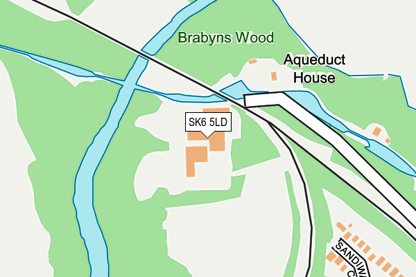
SK6 5LD is located in the Marple North electoral ward, within the metropolitan district of Stockport and the English Parliamentary constituency of Hazel Grove. The Sub Integrated Care Board (ICB) Location is NHS Greater Manchester ICB - 01W and the police force is Greater Manchester. This postcode has been in use since June 1996.


GetTheData
Source: OS OpenMap – Local (Ordnance Survey)
Source: OS VectorMap District (Ordnance Survey)
Licence: Open Government Licence (requires attribution)
| Easting | 395635 |
| Northing | 389974 |
| Latitude | 53.406580 |
| Longitude | -2.067123 |
GetTheData
Source: Open Postcode Geo
Licence: Open Government Licence
| Country | England |
| Postcode District | SK6 |
| ➜ SK6 open data dashboard ➜ See where SK6 is on a map | |
GetTheData
Source: Land Registry Price Paid Data
Licence: Open Government Licence
Elevation or altitude of SK6 5LD as distance above sea level:
| Metres | Feet | |
|---|---|---|
| Elevation | 100m | 328ft |
Elevation is measured from the approximate centre of the postcode, to the nearest point on an OS contour line from OS Terrain 50, which has contour spacing of ten vertical metres.
➜ How high above sea level am I? Find the elevation of your current position using your device's GPS.
GetTheData
Source: Open Postcode Elevation
Licence: Open Government Licence
| Ward | Marple North |
| Constituency | Hazel Grove |
GetTheData
Source: ONS Postcode Database
Licence: Open Government Licence
| Alamein Drive (Nebd) (Alamein Drive) | Cherry Tree | 665m |
| Grosvenor Rd (Ebd) (Grosvenor Road) | Marple | 721m |
| Cherry Tree Ln (Nbd) (Cherry Tree La) | Cherry Tree | 754m |
| Alamein Dr (Swbd) (Alamein Drive) | Cherry Tree | 867m |
| Compstall Rd/Waterloo Rd (Compstall Rd) | Cherry Tree | 922m |
| Marple Station | 0.9km |
| Rose Hill Marple Station | 1.3km |
| Romiley Station | 1.7km |
GetTheData
Source: NaPTAN
Licence: Open Government Licence
GetTheData
Source: ONS Postcode Database
Licence: Open Government Licence


➜ Get more ratings from the Food Standards Agency
GetTheData
Source: Food Standards Agency
Licence: FSA terms & conditions
| Last Collection | |||
|---|---|---|---|
| Location | Mon-Fri | Sat | Distance |
| Jessop Dr | 17:45 | 11:30 | 403m |
| Watermeetings Lane | 17:15 | 11:30 | 673m |
| Manor Road | 17:45 | 11:30 | 751m |
GetTheData
Source: Dracos
Licence: Creative Commons Attribution-ShareAlike
| Facility | Distance |
|---|---|
| Brabyns Park Marple Bridge, Stockport Grass Pitches | 539m |
| Gotherage Lane Playing Fields Gotherage Lane, Romiley, Stockport Grass Pitches | 886m |
| Brabyns Lawn Tennis Club Brabyns Brow, Brabyns Brow, Marple Bridge, Stockport Outdoor Tennis Courts | 899m |
GetTheData
Source: Active Places
Licence: Open Government Licence
| School | Phase of Education | Distance |
|---|---|---|
| Ludworth Primary School Ludworth Primary School, Lower Fold, Marple Bridge, Stockport, SK6 5DU | Primary | 977m |
| Rose Hill Primary School Elmfield Drive, Marple, Stockport, SK6 6DW | Primary | 1.1km |
| St Mary's Catholic Voluntary Academy Lowry Drive, Marple Bridge, Stockport, SK6 5BR | Primary | 1.1km |
GetTheData
Source: Edubase
Licence: Open Government Licence
The below table lists the International Territorial Level (ITL) codes (formerly Nomenclature of Territorial Units for Statistics (NUTS) codes) and Local Administrative Units (LAU) codes for SK6 5LD:
| ITL 1 Code | Name |
|---|---|
| TLD | North West (England) |
| ITL 2 Code | Name |
| TLD3 | Greater Manchester |
| ITL 3 Code | Name |
| TLD35 | Greater Manchester South East |
| LAU 1 Code | Name |
| E08000007 | Stockport |
GetTheData
Source: ONS Postcode Directory
Licence: Open Government Licence
The below table lists the Census Output Area (OA), Lower Layer Super Output Area (LSOA), and Middle Layer Super Output Area (MSOA) for SK6 5LD:
| Code | Name | |
|---|---|---|
| OA | E00029795 | |
| LSOA | E01005883 | Stockport 017C |
| MSOA | E02001203 | Stockport 017 |
GetTheData
Source: ONS Postcode Directory
Licence: Open Government Licence
| SK6 6QA | Sandiway Close | 267m |
| SK6 6QB | Jessop Drive | 331m |
| SK6 6PZ | Wentworth Close | 384m |
| SK6 6QD | Wheelwright Close | 400m |
| SK6 5LB | 416m | |
| SK6 6PY | Kenilworth Close | 425m |
| SK6 6PX | Beacon View | 428m |
| SK6 6QE | Green Meadows Drive | 433m |
| SK6 6PU | Crompton Close | 502m |
| SK6 6QF | Green Meadows | 505m |
GetTheData
Source: Open Postcode Geo; Land Registry Price Paid Data
Licence: Open Government Licence