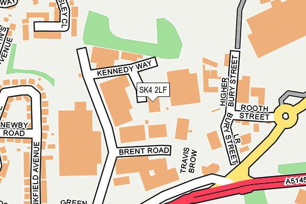
SK4 2LF is located in the Heatons South electoral ward, within the metropolitan district of Stockport and the English Parliamentary constituency of Stockport. The Sub Integrated Care Board (ICB) Location is NHS Greater Manchester ICB - 01W and the police force is Greater Manchester. This postcode has been in use since January 1980.


GetTheData
Source: OS OpenMap – Local (Ordnance Survey)
Source: OS VectorMap District (Ordnance Survey)
Licence: Open Government Licence (requires attribution)
| Easting | 388502 |
| Northing | 390577 |
| Latitude | 53.411876 |
| Longitude | -2.174441 |
GetTheData
Source: Open Postcode Geo
Licence: Open Government Licence
| Country | England |
| Postcode District | SK4 |
| ➜ SK4 open data dashboard ➜ See where SK4 is on a map ➜ Where is Stockport? | |
GetTheData
Source: Land Registry Price Paid Data
Licence: Open Government Licence
Elevation or altitude of SK4 2LF as distance above sea level:
| Metres | Feet | |
|---|---|---|
| Elevation | 60m | 197ft |
Elevation is measured from the approximate centre of the postcode, to the nearest point on an OS contour line from OS Terrain 50, which has contour spacing of ten vertical metres.
➜ How high above sea level am I? Find the elevation of your current position using your device's GPS.
GetTheData
Source: Open Postcode Elevation
Licence: Open Government Licence
| Ward | Heatons South |
| Constituency | Stockport |
GetTheData
Source: ONS Postcode Database
Licence: Open Government Licence
| Travis Brow/Junction 1 (Travis Brow) | Stockport | 182m |
| Travis Brow/Georges Rd (Travis Brow) | Stockport | 271m |
| Travis Brow/Georges Rd (Travis Brow) | Stockport | 276m |
| Didsbury Rd/Norris Bank (Didsbury Rd) | Heaton Mersey | 350m |
| Didsbury Road/Norris Bank (Didsbury Road) | Heaton Mersey | 369m |
| Stockport Station | 1km |
| Heaton Chapel Station | 1.6km |
| Davenport Station | 2.7km |
GetTheData
Source: NaPTAN
Licence: Open Government Licence
GetTheData
Source: ONS Postcode Database
Licence: Open Government Licence


➜ Get more ratings from the Food Standards Agency
GetTheData
Source: Food Standards Agency
Licence: FSA terms & conditions
| Last Collection | |||
|---|---|---|---|
| Location | Mon-Fri | Sat | Distance |
| Green Lane | 19:30 | 13:45 | 88m |
| Green Lane Mail Centre | 19:30 | 98m | |
| Norris Bank Tso | 16:30 | 11:30 | 356m |
GetTheData
Source: Dracos
Licence: Creative Commons Attribution-ShareAlike
| Facility | Distance |
|---|---|
| Bowerfold Openspace Green Lane, Stockport Grass Pitches | 201m |
| Puregym (Stockport North) Kings View, Didsbury Road, Didsbury Road, Stockport Health and Fitness Gym | 418m |
| Hollywood Park Lottery Street, Stockport Grass Pitches | 680m |
GetTheData
Source: Active Places
Licence: Open Government Licence
| School | Phase of Education | Distance |
|---|---|---|
| Progress Schools - Stockport Belgrave House, 211 Chestergate, Stockport, SK3 0AN | Not applicable | 550m |
| Hollywood Park Nursery School Hardman Street, Chestergate, Stockport, SK3 0BJ | Nursery | 600m |
| Norris Bank Primary School Green Lane, Heaton Norris, Stockport, SK4 2NF | Primary | 724m |
GetTheData
Source: Edubase
Licence: Open Government Licence
The below table lists the International Territorial Level (ITL) codes (formerly Nomenclature of Territorial Units for Statistics (NUTS) codes) and Local Administrative Units (LAU) codes for SK4 2LF:
| ITL 1 Code | Name |
|---|---|
| TLD | North West (England) |
| ITL 2 Code | Name |
| TLD3 | Greater Manchester |
| ITL 3 Code | Name |
| TLD35 | Greater Manchester South East |
| LAU 1 Code | Name |
| E08000007 | Stockport |
GetTheData
Source: ONS Postcode Directory
Licence: Open Government Licence
The below table lists the Census Output Area (OA), Lower Layer Super Output Area (LSOA), and Middle Layer Super Output Area (MSOA) for SK4 2LF:
| Code | Name | |
|---|---|---|
| OA | E00029680 | |
| LSOA | E01005861 | Stockport 011D |
| MSOA | E02001197 | Stockport 011 |
GetTheData
Source: ONS Postcode Directory
Licence: Open Government Licence
| SK4 2JH | Bankfield Avenue | 233m |
| SK4 2LH | Dalebrook Court | 240m |
| SK4 2LW | Locksley Close | 255m |
| SK4 2JJ | Newby Road | 279m |
| SK4 2LU | Bowerfold Lane | 305m |
| SK4 2JQ | Norris Avenue | 313m |
| SK4 2LT | Bowerfold Lane | 318m |
| SK4 2NB | Mount Road | 321m |
| SK4 2JL | Didsbury Road | 335m |
| SK4 2JF | St Martins Avenue | 339m |
GetTheData
Source: Open Postcode Geo; Land Registry Price Paid Data
Licence: Open Government Licence