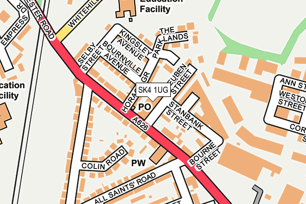
SK4 1UG is located in the Reddish South electoral ward, within the metropolitan district of Stockport and the English Parliamentary constituency of Denton and Reddish. The Sub Integrated Care Board (ICB) Location is NHS Greater Manchester ICB - 01W and the police force is Greater Manchester. This postcode has been in use since January 1980.


GetTheData
Source: OS OpenMap – Local (Ordnance Survey)
Source: OS VectorMap District (Ordnance Survey)
Licence: Open Government Licence (requires attribution)
| Easting | 389106 |
| Northing | 391709 |
| Latitude | 53.422063 |
| Longitude | -2.165394 |
GetTheData
Source: Open Postcode Geo
Licence: Open Government Licence
| Country | England |
| Postcode District | SK4 |
| ➜ SK4 open data dashboard ➜ See where SK4 is on a map ➜ Where is Stockport? | |
GetTheData
Source: Land Registry Price Paid Data
Licence: Open Government Licence
Elevation or altitude of SK4 1UG as distance above sea level:
| Metres | Feet | |
|---|---|---|
| Elevation | 70m | 230ft |
Elevation is measured from the approximate centre of the postcode, to the nearest point on an OS contour line from OS Terrain 50, which has contour spacing of ten vertical metres.
➜ How high above sea level am I? Find the elevation of your current position using your device's GPS.
GetTheData
Source: Open Postcode Elevation
Licence: Open Government Licence
| Ward | Reddish South |
| Constituency | Denton And Reddish |
GetTheData
Source: ONS Postcode Database
Licence: Open Government Licence
| November 2022 | Violence and sexual offences | On or near Petrol Station | 159m |
| ➜ Get more crime data in our Crime section | |||
GetTheData
Source: data.police.uk
Licence: Open Government Licence
| Manchester Rd/All Saints Church (Manchester Rd) | South Reddish | 43m |
| Manchester Rd/All Saints Church (Manchester Rd) | South Reddish | 107m |
| Manchester Rd/Ash Hotel (Manchester Rd) | South Reddish | 170m |
| Whitehill St West/Manchester Rd (Whitehill St We) | South Reddish | 233m |
| Manchester Rd/Retail Park (Manchester Rd) | Lancashire Hill | 308m |
| Heaton Chapel Station | 1km |
| Reddish South Station | 1.6km |
| Stockport Station | 1.8km |
GetTheData
Source: NaPTAN
Licence: Open Government Licence
GetTheData
Source: ONS Postcode Database
Licence: Open Government Licence

➜ Get more ratings from the Food Standards Agency
GetTheData
Source: Food Standards Agency
Licence: FSA terms & conditions
| Last Collection | |||
|---|---|---|---|
| Location | Mon-Fri | Sat | Distance |
| Reuben Street | 17:30 | 11:15 | 46m |
| Manchester Road | 17:30 | 11:30 | 376m |
| Belmont Way | 17:30 | 11:15 | 508m |
GetTheData
Source: Dracos
Licence: Creative Commons Attribution-ShareAlike
| Facility | Distance |
|---|---|
| Whitehill Primary School Whitehill Street West, Whitehill Industrial Estate, Stockport Grass Pitches | 200m |
| Frederick Whittaker Scott Playing Fields Conway Street, Stockport Grass Pitches | 263m |
| All Saints Primary School Churchill Street, Stockport Grass Pitches | 295m |
GetTheData
Source: Active Places
Licence: Open Government Licence
| School | Phase of Education | Distance |
|---|---|---|
| Whitehill Primary School Whitehill Street West, Heaton Norris, Stockport, SK4 1PB | Primary | 200m |
| Moat House 6 Lower Moat Close, Heaton Norris, Stockport, SK4 1SZ | Not applicable | 337m |
| St Anne's RC Voluntary Academy Glenfield Road, Heaton Chapel, Stockport, SK4 2QP | Secondary | 380m |
GetTheData
Source: Edubase
Licence: Open Government Licence
The below table lists the International Territorial Level (ITL) codes (formerly Nomenclature of Territorial Units for Statistics (NUTS) codes) and Local Administrative Units (LAU) codes for SK4 1UG:
| ITL 1 Code | Name |
|---|---|
| TLD | North West (England) |
| ITL 2 Code | Name |
| TLD3 | Greater Manchester |
| ITL 3 Code | Name |
| TLD35 | Greater Manchester South East |
| LAU 1 Code | Name |
| E08000007 | Stockport |
GetTheData
Source: ONS Postcode Directory
Licence: Open Government Licence
The below table lists the Census Output Area (OA), Lower Layer Super Output Area (LSOA), and Middle Layer Super Output Area (MSOA) for SK4 1UG:
| Code | Name | |
|---|---|---|
| OA | E00029959 | |
| LSOA | E01005916 | Stockport 007C |
| MSOA | E02001193 | Stockport 007 |
GetTheData
Source: ONS Postcode Directory
Licence: Open Government Licence
| SK4 1PP | Horace Grove | 35m |
| SK4 1NN | Manchester Road | 40m |
| SK4 1PU | Morton Street | 61m |
| SK4 1PS | Reuben Street | 67m |
| SK4 1NL | Manchester Road | 69m |
| SK4 1PX | Stanbank Street | 94m |
| SK4 1PR | Bournville Avenue | 103m |
| SK4 1PW | Kingsley Avenue | 109m |
| SK4 1QZ | The Parklands | 121m |
| SK4 1NJ | Colin Road | 137m |
GetTheData
Source: Open Postcode Geo; Land Registry Price Paid Data
Licence: Open Government Licence