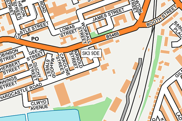
SK3 9DE is located in the Edgeley electoral ward, within the metropolitan district of Stockport and the English Parliamentary constituency of Stockport. The Sub Integrated Care Board (ICB) Location is NHS Greater Manchester ICB - 01W and the police force is Greater Manchester. This postcode has been in use since January 1980.


GetTheData
Source: OS OpenMap – Local (Ordnance Survey)
Source: OS VectorMap District (Ordnance Survey)
Licence: Open Government Licence (requires attribution)
| Easting | 389065 |
| Northing | 389302 |
| Latitude | 53.400427 |
| Longitude | -2.165926 |
GetTheData
Source: Open Postcode Geo
Licence: Open Government Licence
| Country | England |
| Postcode District | SK3 |
| ➜ SK3 open data dashboard ➜ See where SK3 is on a map ➜ Where is Stockport? | |
GetTheData
Source: Land Registry Price Paid Data
Licence: Open Government Licence
Elevation or altitude of SK3 9DE as distance above sea level:
| Metres | Feet | |
|---|---|---|
| Elevation | 70m | 230ft |
Elevation is measured from the approximate centre of the postcode, to the nearest point on an OS contour line from OS Terrain 50, which has contour spacing of ten vertical metres.
➜ How high above sea level am I? Find the elevation of your current position using your device's GPS.
GetTheData
Source: Open Postcode Elevation
Licence: Open Government Licence
| Ward | Edgeley |
| Constituency | Stockport |
GetTheData
Source: ONS Postcode Database
Licence: Open Government Licence
| February 2022 | Violence and sexual offences | On or near Longshut Lane | 461m |
| June 2021 | Violence and sexual offences | On or near Ladysmith Street | 358m |
| March 2021 | Violence and sexual offences | On or near Parking Area | 250m |
| ➜ Get more crime data in our Crime section | |||
GetTheData
Source: data.police.uk
Licence: Open Government Licence
| Mercian Way/Worral St (Mercian Way) | Edgeley | 81m |
| Mercian Way/Worral St (Mercian Way) | Edgeley | 93m |
| Worrall St (Sbd) (Worrall Street) | Edgeley | 123m |
| Lomas St (Wbd) (Lomas Street) | Edgeley | 154m |
| Castle St/Worrall St (Castle St) | Edgeley | 176m |
| Stockport Station | 0.6km |
| Davenport Station | 1.4km |
| Woodsmoor Station | 2.2km |
GetTheData
Source: NaPTAN
Licence: Open Government Licence
GetTheData
Source: ONS Postcode Database
Licence: Open Government Licence


➜ Get more ratings from the Food Standards Agency
GetTheData
Source: Food Standards Agency
Licence: FSA terms & conditions
| Last Collection | |||
|---|---|---|---|
| Location | Mon-Fri | Sat | Distance |
| Castle Street | 17:30 | 12:15 | 169m |
| York Street | 17:30 | 12:00 | 243m |
| Berlin Road | 17:30 | 11:45 | 288m |
GetTheData
Source: Dracos
Licence: Creative Commons Attribution-ShareAlike
| Facility | Distance |
|---|---|
| Edgeley Park Stadium (Stockport County Fc) Hardcastle Road, Stockport Grass Pitches | 98m |
| Our Lady's Catholic Primary School Old Chapel Street, Stockport Sports Hall, Artificial Grass Pitch | 330m |
| The Armoury Greek Street, Stockport Sports Hall | 408m |
GetTheData
Source: Active Places
Licence: Open Government Licence
| School | Phase of Education | Distance |
|---|---|---|
| Our Lady's Catholic Primary School Old Chapel Street, Edgeley, Stockport, SK3 9HX | Primary | 330m |
| St Matthew's Church of England Primary School Bowdon Street, Edgeley, Stockport, SK3 9EA | Primary | 375m |
| Cale Green Primary School Shaw Road South, Shaw Heath, Stockport, SK3 8JG | Primary | 569m |
GetTheData
Source: Edubase
Licence: Open Government Licence
The below table lists the International Territorial Level (ITL) codes (formerly Nomenclature of Territorial Units for Statistics (NUTS) codes) and Local Administrative Units (LAU) codes for SK3 9DE:
| ITL 1 Code | Name |
|---|---|
| TLD | North West (England) |
| ITL 2 Code | Name |
| TLD3 | Greater Manchester |
| ITL 3 Code | Name |
| TLD35 | Greater Manchester South East |
| LAU 1 Code | Name |
| E08000007 | Stockport |
GetTheData
Source: ONS Postcode Directory
Licence: Open Government Licence
The below table lists the Census Output Area (OA), Lower Layer Super Output Area (LSOA), and Middle Layer Super Output Area (MSOA) for SK3 9DE:
| Code | Name | |
|---|---|---|
| OA | E00029178 | |
| LSOA | E01005764 | Stockport 016A |
| MSOA | E02001202 | Stockport 016 |
GetTheData
Source: ONS Postcode Directory
Licence: Open Government Licence
| SK3 9BN | Arnold Street | 37m |
| SK3 9BE | Worrall Street | 50m |
| SK3 9DF | Mercian Way | 73m |
| SK3 9BW | Caroline Street | 107m |
| SK3 9DB | Hardcastle Road | 112m |
| SK3 9BD | Cecil Street | 121m |
| SK3 9BP | Mahood Street | 134m |
| SK3 9BB | Harper Street | 138m |
| SK3 9AG | James Street | 143m |
| SK3 9BR | Gee Street | 160m |
GetTheData
Source: Open Postcode Geo; Land Registry Price Paid Data
Licence: Open Government Licence