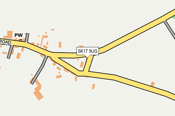
SK17 9UG lies on Dale View in Taddington, Buxton. SK17 9UG is located in the Hartington & Taddington electoral ward, within the local authority district of Derbyshire Dales and the English Parliamentary constituency of Derbyshire Dales. The Sub Integrated Care Board (ICB) Location is NHS Derby and Derbyshire ICB - 15M and the police force is Derbyshire. This postcode has been in use since January 1980.


GetTheData
Source: OS OpenMap – Local (Ordnance Survey)
Source: OS VectorMap District (Ordnance Survey)
Licence: Open Government Licence (requires attribution)
| Easting | 414764 |
| Northing | 370977 |
| Latitude | 53.235640 |
| Longitude | -1.780262 |
GetTheData
Source: Open Postcode Geo
Licence: Open Government Licence
| Street | Dale View |
| Locality | Taddington |
| Town/City | Buxton |
| Country | England |
| Postcode District | SK17 |
| ➜ SK17 open data dashboard ➜ See where SK17 is on a map ➜ Where is Taddington? | |
GetTheData
Source: Land Registry Price Paid Data
Licence: Open Government Licence
Elevation or altitude of SK17 9UG as distance above sea level:
| Metres | Feet | |
|---|---|---|
| Elevation | 310m | 1,017ft |
Elevation is measured from the approximate centre of the postcode, to the nearest point on an OS contour line from OS Terrain 50, which has contour spacing of ten vertical metres.
➜ How high above sea level am I? Find the elevation of your current position using your device's GPS.
GetTheData
Source: Open Postcode Elevation
Licence: Open Government Licence
| Ward | Hartington & Taddington |
| Constituency | Derbyshire Dales |
GetTheData
Source: ONS Postcode Database
Licence: Open Government Licence
| June 2022 | Violence and sexual offences | On or near Chapel Lane | 222m |
| October 2021 | Burglary | On or near Chapel Lane | 222m |
| September 2021 | Criminal damage and arson | On or near Chapel Lane | 222m |
| ➜ Get more crime data in our Crime section | |||
GetTheData
Source: data.police.uk
Licence: Open Government Licence
| Town End (Main Road) | Taddington | 27m |
| Town End (Main Road) | Taddington | 34m |
| Chapel Lane (Main Road) | Taddington | 232m |
| Chapel Lane (Main Road) | Taddington | 233m |
| Smithy Lane (Main Road) | Taddington | 481m |
GetTheData
Source: NaPTAN
Licence: Open Government Licence
| Percentage of properties with Next Generation Access | 100.0% |
| Percentage of properties with Superfast Broadband | 100.0% |
| Percentage of properties with Ultrafast Broadband | 0.0% |
| Percentage of properties with Full Fibre Broadband | 0.0% |
Superfast Broadband is between 30Mbps and 300Mbps
Ultrafast Broadband is > 300Mbps
| Percentage of properties unable to receive 2Mbps | 0.0% |
| Percentage of properties unable to receive 5Mbps | 0.0% |
| Percentage of properties unable to receive 10Mbps | 0.0% |
| Percentage of properties unable to receive 30Mbps | 0.0% |
GetTheData
Source: Ofcom
Licence: Ofcom Terms of Use (requires attribution)
GetTheData
Source: ONS Postcode Database
Licence: Open Government Licence


➜ Get more ratings from the Food Standards Agency
GetTheData
Source: Food Standards Agency
Licence: FSA terms & conditions
| Last Collection | |||
|---|---|---|---|
| Location | Mon-Fri | Sat | Distance |
| Taddington | 12:00 | 11:00 | 490m |
| Pristcliffe | 09:45 | 09:00 | 1,378m |
| Blackwell | 09:00 | 09:00 | 2,204m |
GetTheData
Source: Dracos
Licence: Creative Commons Attribution-ShareAlike
| Facility | Distance |
|---|---|
| Great Longstone Thornbridge, Great Longstone, Bakewell Cycling | 5km |
| Sterndale Moor Sterndale Moor, Buxton Grass Pitches | 5.4km |
GetTheData
Source: Active Places
Licence: Open Government Licence
| School | Phase of Education | Distance |
|---|---|---|
| Taddington and Priestcliffe School Taddington, Buxton, SK17 9TW | Primary | 1km |
| Flagg Nursery School Main Road, Flagg, Near Buxton, SK17 9QT | Nursery | 2.9km |
| Monyash CofE Primary School Church Street, Monyash, Bakewell, DE45 1JH | Primary | 4.5km |
GetTheData
Source: Edubase
Licence: Open Government Licence
The below table lists the International Territorial Level (ITL) codes (formerly Nomenclature of Territorial Units for Statistics (NUTS) codes) and Local Administrative Units (LAU) codes for SK17 9UG:
| ITL 1 Code | Name |
|---|---|
| TLF | East Midlands (England) |
| ITL 2 Code | Name |
| TLF1 | Derbyshire and Nottinghamshire |
| ITL 3 Code | Name |
| TLF13 | South and West Derbyshire |
| LAU 1 Code | Name |
| E07000035 | Derbyshire Dales |
GetTheData
Source: ONS Postcode Directory
Licence: Open Government Licence
The below table lists the Census Output Area (OA), Lower Layer Super Output Area (LSOA), and Middle Layer Super Output Area (MSOA) for SK17 9UG:
| Code | Name | |
|---|---|---|
| OA | E00099225 | |
| LSOA | E01019613 | Derbyshire Dales 003C |
| MSOA | E02004070 | Derbyshire Dales 003 |
GetTheData
Source: ONS Postcode Directory
Licence: Open Government Licence
| SK17 9UF | Town End | 77m |
| SK17 9UD | Main Street | 180m |
| SK17 9UE | Hall Lane | 230m |
| SK17 9UB | Main Street | 432m |
| SK17 9TZ | Meadow View | 441m |
| SK17 9UA | Smithy Lane | 471m |
| SK17 9TY | Main Street | 519m |
| SK17 9TX | Main Street | 555m |
| SK17 9TU | Main Street | 602m |
| SK17 9TS | Humphrey Gate | 656m |
GetTheData
Source: Open Postcode Geo; Land Registry Price Paid Data
Licence: Open Government Licence