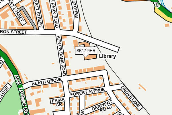
SK17 9HR is located in the Cote Heath electoral ward, within the local authority district of High Peak and the English Parliamentary constituency of High Peak. The Sub Integrated Care Board (ICB) Location is NHS Derby and Derbyshire ICB - 15M and the police force is Derbyshire. This postcode has been in use since December 1999.


GetTheData
Source: OS OpenMap – Local (Ordnance Survey)
Source: OS VectorMap District (Ordnance Survey)
Licence: Open Government Licence (requires attribution)
| Easting | 406243 |
| Northing | 372769 |
| Latitude | 53.251898 |
| Longitude | -1.907890 |
GetTheData
Source: Open Postcode Geo
Licence: Open Government Licence
| Country | England |
| Postcode District | SK17 |
| ➜ SK17 open data dashboard ➜ See where SK17 is on a map ➜ Where is Buxton? | |
GetTheData
Source: Land Registry Price Paid Data
Licence: Open Government Licence
Elevation or altitude of SK17 9HR as distance above sea level:
| Metres | Feet | |
|---|---|---|
| Elevation | 310m | 1,017ft |
Elevation is measured from the approximate centre of the postcode, to the nearest point on an OS contour line from OS Terrain 50, which has contour spacing of ten vertical metres.
➜ How high above sea level am I? Find the elevation of your current position using your device's GPS.
GetTheData
Source: Open Postcode Elevation
Licence: Open Government Licence
| Ward | Cote Heath |
| Constituency | High Peak |
GetTheData
Source: ONS Postcode Database
Licence: Open Government Licence
| June 2022 | Violence and sexual offences | On or near Heath Grove | 105m |
| June 2022 | Other theft | On or near Forest Avenue | 120m |
| June 2022 | Violence and sexual offences | On or near Friar Grove | 176m |
| ➜ Get more crime data in our Crime section | |||
GetTheData
Source: data.police.uk
Licence: Open Government Licence
| Kents Bank Road (Heath Grove) | Buxton | 74m |
| Cote Heath Park (Heath Park Road) | Buxton | 153m |
| Cote Heath Park (Heath Park Road) | Buxton | 158m |
| Heath Grove (London Road) | Buxton | 248m |
| Aldwark Road East (Sherwood Road) | Buxton | 254m |
| Buxton Station | 1km |
GetTheData
Source: NaPTAN
Licence: Open Government Licence
GetTheData
Source: ONS Postcode Database
Licence: Open Government Licence


➜ Get more ratings from the Food Standards Agency
GetTheData
Source: Food Standards Agency
Licence: FSA terms & conditions
| Last Collection | |||
|---|---|---|---|
| Location | Mon-Fri | Sat | Distance |
| Crowestone | 17:30 | 11:00 | 150m |
| Dale Road | 17:30 | 11:00 | 216m |
| London Road | 17:30 | 12:00 | 247m |
GetTheData
Source: Dracos
Licence: Creative Commons Attribution-ShareAlike
| Facility | Distance |
|---|---|
| Cote Heath Park Byron Street, Buxton Grass Pitches | 168m |
| Buxton Fc (The Tarmac Silverlands Stadium) Silverlands, Buxton Grass Pitches, Artificial Grass Pitch | 543m |
| Buxton Junior School Mosley Road, Buxton Grass Pitches | 545m |
GetTheData
Source: Active Places
Licence: Open Government Licence
| School | Phase of Education | Distance |
|---|---|---|
| Buxton Junior School Buxton Junior School, Mosley Road, Buxton, SK17 9DR | Primary | 371m |
| Buxton Infant School Hardwick Square, Buxton, SK17 6QB | Primary | 599m |
| Harpur Hill Primary School Trent Avenue, Harpur Hill, Buxton, SK17 9LP | Primary | 881m |
GetTheData
Source: Edubase
Licence: Open Government Licence
The below table lists the International Territorial Level (ITL) codes (formerly Nomenclature of Territorial Units for Statistics (NUTS) codes) and Local Administrative Units (LAU) codes for SK17 9HR:
| ITL 1 Code | Name |
|---|---|
| TLF | East Midlands (England) |
| ITL 2 Code | Name |
| TLF1 | Derbyshire and Nottinghamshire |
| ITL 3 Code | Name |
| TLF13 | South and West Derbyshire |
| LAU 1 Code | Name |
| E07000037 | High Peak |
GetTheData
Source: ONS Postcode Directory
Licence: Open Government Licence
The below table lists the Census Output Area (OA), Lower Layer Super Output Area (LSOA), and Middle Layer Super Output Area (MSOA) for SK17 9HR:
| Code | Name | |
|---|---|---|
| OA | E00099808 | |
| LSOA | E01019724 | High Peak 011B |
| MSOA | E02004103 | High Peak 011 |
GetTheData
Source: ONS Postcode Directory
Licence: Open Government Licence
| SK17 9HH | Heath Grove | 43m |
| SK17 9HJ | Kents Bank Road | 66m |
| SK17 9HE | Forest Avenue | 104m |
| SK17 9HQ | Sherwood Road | 108m |
| SK17 9EL | Sherwood Road | 120m |
| SK17 6NT | Byron Street | 127m |
| SK17 9HF | Sherwood Road | 158m |
| SK17 9HD | Derwent Road | 162m |
| SK17 9EN | Friar Grove | 172m |
| SK17 9EH | Heath Grove | 176m |
GetTheData
Source: Open Postcode Geo; Land Registry Price Paid Data
Licence: Open Government Licence