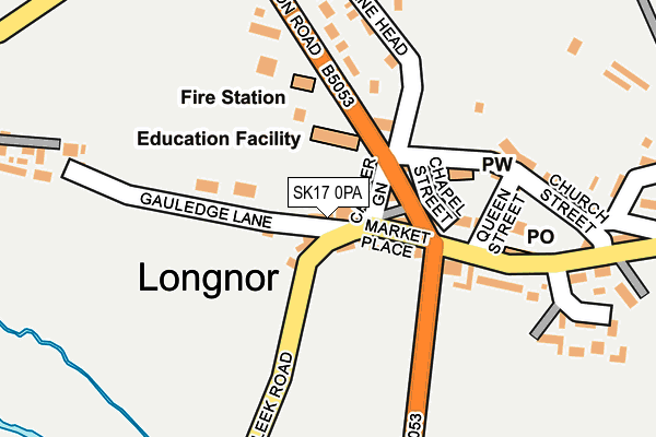
SK17 0PA is in Longnor, Buxton. SK17 0PA is located in the Manifold electoral ward, within the local authority district of Staffordshire Moorlands and the English Parliamentary constituency of Staffordshire Moorlands. The Sub Integrated Care Board (ICB) Location is NHS Staffordshire and Stoke-on-Trent ICB - 05G and the police force is Staffordshire. This postcode has been in use since January 1980.


GetTheData
Source: OS OpenMap – Local (Ordnance Survey)
Source: OS VectorMap District (Ordnance Survey)
Licence: Open Government Licence (requires attribution)
| Easting | 408753 |
| Northing | 364940 |
| Latitude | 53.181508 |
| Longitude | -1.870480 |
GetTheData
Source: Open Postcode Geo
Licence: Open Government Licence
| Locality | Longnor |
| Town/City | Buxton |
| Country | England |
| Postcode District | SK17 |
| ➜ SK17 open data dashboard ➜ See where SK17 is on a map ➜ Where is Longnor? | |
GetTheData
Source: Land Registry Price Paid Data
Licence: Open Government Licence
Elevation or altitude of SK17 0PA as distance above sea level:
| Metres | Feet | |
|---|---|---|
| Elevation | 280m | 919ft |
Elevation is measured from the approximate centre of the postcode, to the nearest point on an OS contour line from OS Terrain 50, which has contour spacing of ten vertical metres.
➜ How high above sea level am I? Find the elevation of your current position using your device's GPS.
GetTheData
Source: Open Postcode Elevation
Licence: Open Government Licence
| Ward | Manifold |
| Constituency | Staffordshire Moorlands |
GetTheData
Source: ONS Postcode Database
Licence: Open Government Licence
| June 2022 | Criminal damage and arson | On or near High Street | 238m |
| April 2022 | Public order | On or near Windyridge | 230m |
| April 2022 | Violence and sexual offences | On or near Windyridge | 230m |
| ➜ Get more crime data in our Crime section | |||
GetTheData
Source: data.police.uk
Licence: Open Government Licence
| Market Place (Warslow Rd) | Longnor | 100m |
| Market Place (Warslow Rd) | Longnor | 113m |
| The Grapes Ph (Market Place) | Longnor | 116m |
| The Grapes Ph (High St) | Longnor | 141m |
| Pack Horse (Main Street) | Crowdecote | 1,346m |
GetTheData
Source: NaPTAN
Licence: Open Government Licence
| Percentage of properties with Next Generation Access | 100.0% |
| Percentage of properties with Superfast Broadband | 100.0% |
| Percentage of properties with Ultrafast Broadband | 0.0% |
| Percentage of properties with Full Fibre Broadband | 0.0% |
Superfast Broadband is between 30Mbps and 300Mbps
Ultrafast Broadband is > 300Mbps
| Percentage of properties unable to receive 2Mbps | 0.0% |
| Percentage of properties unable to receive 5Mbps | 0.0% |
| Percentage of properties unable to receive 10Mbps | 0.0% |
| Percentage of properties unable to receive 30Mbps | 0.0% |
GetTheData
Source: Ofcom
Licence: Ofcom Terms of Use (requires attribution)
Estimated total energy consumption in SK17 0PA by fuel type, 2015.
| Consumption (kWh) | 88,823 |
|---|---|
| Meter count | 21 |
| Mean (kWh/meter) | 4,230 |
| Median (kWh/meter) | 3,017 |
GetTheData
Source: Postcode level gas estimates: 2015 (experimental)
Source: Postcode level electricity estimates: 2015 (experimental)
Licence: Open Government Licence
GetTheData
Source: ONS Postcode Database
Licence: Open Government Licence


➜ Get more ratings from the Food Standards Agency
GetTheData
Source: Food Standards Agency
Licence: FSA terms & conditions
| Last Collection | |||
|---|---|---|---|
| Location | Mon-Fri | Sat | Distance |
| Longnor | 17:15 | 09:00 | 173m |
| Crowdicote | 10:00 | 09:00 | 1,347m |
| Glutton | 12:00 | 10:30 | 1,662m |
GetTheData
Source: Dracos
Licence: Creative Commons Attribution-ShareAlike
| Facility | Distance |
|---|---|
| Sterndale Moor Sterndale Moor, Buxton Grass Pitches | 3.8km |
GetTheData
Source: Active Places
Licence: Open Government Licence
| School | Phase of Education | Distance |
|---|---|---|
| St Bartholomew's CofE (C) School Buxton Road, Longnor, Buxton, SK17 0NZ | Primary | 77m |
| Earl Sterndale CofE Primary School Earl Sterndale, Buxton, SK17 0BS | Primary | 2.2km |
| Hollinsclough Church of England Academy Carr Lane, Hollinsclough, Buxton, SK17 0RH | Primary | 2.8km |
GetTheData
Source: Edubase
Licence: Open Government Licence
The below table lists the International Territorial Level (ITL) codes (formerly Nomenclature of Territorial Units for Statistics (NUTS) codes) and Local Administrative Units (LAU) codes for SK17 0PA:
| ITL 1 Code | Name |
|---|---|
| TLG | West Midlands (England) |
| ITL 2 Code | Name |
| TLG2 | Shropshire and Staffordshire |
| ITL 3 Code | Name |
| TLG24 | Staffordshire CC |
| LAU 1 Code | Name |
| E07000198 | Staffordshire Moorlands |
GetTheData
Source: ONS Postcode Directory
Licence: Open Government Licence
The below table lists the Census Output Area (OA), Lower Layer Super Output Area (LSOA), and Middle Layer Super Output Area (MSOA) for SK17 0PA:
| Code | Name | |
|---|---|---|
| OA | E00151945 | |
| LSOA | E01029817 | Staffordshire Moorlands 007C |
| MSOA | E02006210 | Staffordshire Moorlands 007 |
GetTheData
Source: ONS Postcode Directory
Licence: Open Government Licence
| SK17 0NY | Buxton Road | 83m |
| SK17 0NU | Chapel Street | 102m |
| SK17 0NT | Market Place | 123m |
| SK17 0NS | River View | 157m |
| SK17 0PF | Queen Street | 169m |
| SK17 0NZ | Buxton Road | 173m |
| SK17 0PE | Church Street | 187m |
| SK17 0PD | 217m | |
| SK17 0PG | High Street | 235m |
| SK17 0PH | Myrtle Cottages | 255m |
GetTheData
Source: Open Postcode Geo; Land Registry Price Paid Data
Licence: Open Government Licence