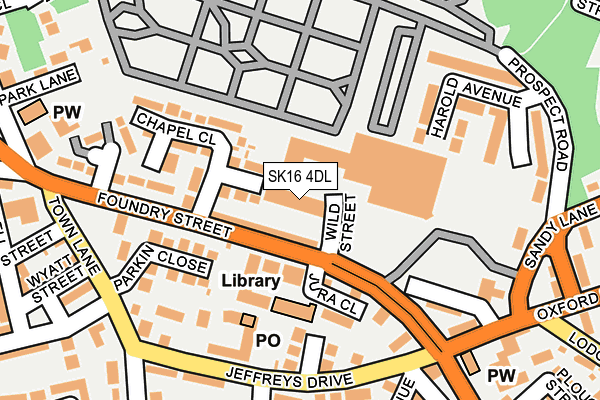
SK16 4DL is located in the Dukinfield electoral ward, within the metropolitan district of Tameside and the English Parliamentary constituency of Denton and Reddish. The Sub Integrated Care Board (ICB) Location is NHS Greater Manchester ICB - 01Y and the police force is Greater Manchester. This postcode has been in use since January 1980.


GetTheData
Source: OS OpenMap – Local (Ordnance Survey)
Source: OS VectorMap District (Ordnance Survey)
Licence: Open Government Licence (requires attribution)
| Easting | 394643 |
| Northing | 397874 |
| Latitude | 53.477580 |
| Longitude | -2.082183 |
GetTheData
Source: Open Postcode Geo
Licence: Open Government Licence
| Country | England |
| Postcode District | SK16 |
| ➜ SK16 open data dashboard ➜ See where SK16 is on a map ➜ Where is Dukinfield? | |
GetTheData
Source: Land Registry Price Paid Data
Licence: Open Government Licence
Elevation or altitude of SK16 4DL as distance above sea level:
| Metres | Feet | |
|---|---|---|
| Elevation | 140m | 459ft |
Elevation is measured from the approximate centre of the postcode, to the nearest point on an OS contour line from OS Terrain 50, which has contour spacing of ten vertical metres.
➜ How high above sea level am I? Find the elevation of your current position using your device's GPS.
GetTheData
Source: Open Postcode Elevation
Licence: Open Government Licence
| Ward | Dukinfield |
| Constituency | Denton And Reddish |
GetTheData
Source: ONS Postcode Database
Licence: Open Government Licence
| August 2021 | Violence and sexual offences | On or near Harold Avenue | 210m |
| ➜ Get more crime data in our Crime section | |||
GetTheData
Source: data.police.uk
Licence: Open Government Licence
| Foundry St/Morrisons (Foundry St) | Dukinfield | 79m |
| Jeffreys Dr/Victoria St (Jeffreys Dr) | Dukinfield | 194m |
| Foundry St/Chapel View (Foundry St) | Dukinfield | 196m |
| Oxford Rd/Albion Hotel (Oxford Rd) | Dukinfield | 207m |
| Oxford Rd/Albion Hotel (Oxford Rd) | Dukinfield | 214m |
| Ashton-under-lyne (Manchester Metrolink) (Wellington Rd) | Ashton Under Lyne | 1,767m |
| Hyde North Station | 1.4km |
| Stalybridge Station | 1.5km |
| Ashton-under-Lyne Station | 1.7km |
GetTheData
Source: NaPTAN
Licence: Open Government Licence
GetTheData
Source: ONS Postcode Database
Licence: Open Government Licence


➜ Get more ratings from the Food Standards Agency
GetTheData
Source: Food Standards Agency
Licence: FSA terms & conditions
| Last Collection | |||
|---|---|---|---|
| Location | Mon-Fri | Sat | Distance |
| Crescent Road | 17:30 | 11:40 | 568m |
| King Street | 17:30 | 12:00 | 763m |
| Clarence Street | 17:00 | 11:30 | 794m |
GetTheData
Source: Dracos
Licence: Creative Commons Attribution-ShareAlike
| Facility | Distance |
|---|---|
| Woodhams Park Birch Lane, Dukinfield Grass Pitches | 625m |
| Armadale Road Playing Fields Armadale Road, Dukinfield Grass Pitches | 643m |
| Blocksages Playing Fields Birch Lane, Dukinfield Grass Pitches | 695m |
GetTheData
Source: Active Places
Licence: Open Government Licence
| School | Phase of Education | Distance |
|---|---|---|
| St John's CofE Primary School, Dukinfield Westmorland Avenue, Dukinfield, SK16 5JA | Primary | 682m |
| All Saints Catholic College Birch Lane, Dukinfield, SK16 5AP | Secondary | 738m |
| Lyndhurst Primary School Lyndhurst Community Primary School, Lyndhurst Community Primary School, Hill Street, Dukinfield, SK16 4JS | Primary | 772m |
GetTheData
Source: Edubase
Licence: Open Government Licence
The below table lists the International Territorial Level (ITL) codes (formerly Nomenclature of Territorial Units for Statistics (NUTS) codes) and Local Administrative Units (LAU) codes for SK16 4DL:
| ITL 1 Code | Name |
|---|---|
| TLD | North West (England) |
| ITL 2 Code | Name |
| TLD3 | Greater Manchester |
| ITL 3 Code | Name |
| TLD35 | Greater Manchester South East |
| LAU 1 Code | Name |
| E08000008 | Tameside |
GetTheData
Source: ONS Postcode Directory
Licence: Open Government Licence
The below table lists the Census Output Area (OA), Lower Layer Super Output Area (LSOA), and Middle Layer Super Output Area (MSOA) for SK16 4DL:
| Code | Name | |
|---|---|---|
| OA | E00030450 | |
| LSOA | E01006009 | Tameside 016A |
| MSOA | E02001244 | Tameside 016 |
GetTheData
Source: ONS Postcode Directory
Licence: Open Government Licence
| SK16 5PN | Foundry Street | 57m |
| SK16 4DG | Princess Close | 78m |
| SK16 4DE | Jura Close | 106m |
| SK16 4DB | Concord Way | 140m |
| SK16 4DA | Shepley Close | 146m |
| SK16 4DF | Chapel Close | 147m |
| SK16 4DD | Parkin Close | 155m |
| SK16 4AA | Atlas Street | 163m |
| SK16 5PH | Foundry Street | 165m |
| SK16 5NH | Harold Avenue | 190m |
GetTheData
Source: Open Postcode Geo; Land Registry Price Paid Data
Licence: Open Government Licence