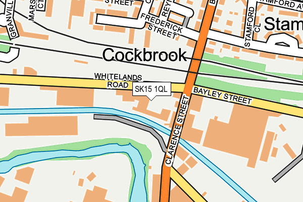
SK15 1QL is located in the Ashton St Michael's electoral ward, within the metropolitan district of Tameside and the English Parliamentary constituency of Ashton-under-Lyne. The Sub Integrated Care Board (ICB) Location is NHS Greater Manchester ICB - 01Y and the police force is Greater Manchester. This postcode has been in use since January 1995.


GetTheData
Source: OS OpenMap – Local (Ordnance Survey)
Source: OS VectorMap District (Ordnance Survey)
Licence: Open Government Licence (requires attribution)
| Easting | 395115 |
| Northing | 398551 |
| Latitude | 53.483670 |
| Longitude | -2.075081 |
GetTheData
Source: Open Postcode Geo
Licence: Open Government Licence
| Country | England |
| Postcode District | SK15 |
| ➜ SK15 open data dashboard ➜ See where SK15 is on a map ➜ Where is Ashton-under-Lyne? | |
GetTheData
Source: Land Registry Price Paid Data
Licence: Open Government Licence
Elevation or altitude of SK15 1QL as distance above sea level:
| Metres | Feet | |
|---|---|---|
| Elevation | 110m | 361ft |
Elevation is measured from the approximate centre of the postcode, to the nearest point on an OS contour line from OS Terrain 50, which has contour spacing of ten vertical metres.
➜ How high above sea level am I? Find the elevation of your current position using your device's GPS.
GetTheData
Source: Open Postcode Elevation
Licence: Open Government Licence
| Ward | Ashton St Michael's |
| Constituency | Ashton-under-lyne |
GetTheData
Source: ONS Postcode Database
Licence: Open Government Licence
| June 2022 | Public order | On or near Crawford Street | 366m |
| April 2022 | Violence and sexual offences | On or near Frederick Street | 141m |
| ➜ Get more crime data in our Crime section | |||
GetTheData
Source: data.police.uk
Licence: Open Government Licence
| Stamford St/Stamford Park (Stamford St) | Stamford Park | 282m |
| Stamford St/Stamford Park (Stamford Square) | Stamford Park | 301m |
| Park Rd/Sandy Ln (Park Rd) | Dukinfield | 350m |
| Stamford Park/Astley Rd (Stamford St) | Stamford Park | 350m |
| Park Rd/The Brunswick (Park Rd) | Dukinfield | 364m |
| Stalybridge Station | 0.8km |
| Ashton-under-Lyne Station | 1.5km |
| Hyde North Station | 2.2km |
GetTheData
Source: NaPTAN
Licence: Open Government Licence
GetTheData
Source: ONS Postcode Database
Licence: Open Government Licence


➜ Get more ratings from the Food Standards Agency
GetTheData
Source: Food Standards Agency
Licence: FSA terms & conditions
| Last Collection | |||
|---|---|---|---|
| Location | Mon-Fri | Sat | Distance |
| Clarence Street | 17:00 | 11:30 | 98m |
| Stamford Park | 17:30 | 11:20 | 306m |
| Grafton Street | 17:30 | 11:25 | 667m |
GetTheData
Source: Dracos
Licence: Creative Commons Attribution-ShareAlike
| Facility | Distance |
|---|---|
| Tameside College Beaufort Road, Ashton-under-lyne Health and Fitness Gym, Sports Hall | 608m |
| West Hill School Sports Centre Stamford Street, Stalybridge Sports Hall, Health and Fitness Gym | 691m |
| Stanley Square Conservative Club Stanley Street, Stalybridge Sports Hall | 695m |
GetTheData
Source: Active Places
Licence: Open Government Licence
| School | Phase of Education | Distance |
|---|---|---|
| Tameside College Beaufort Road, Ashton-under-Lyne, OL6 6NX | 16 plus | 608m |
| West Hill School Thompson Cross, Stamford Street, Stalybridge, SK15 1LX | Secondary | 691m |
| Parochial CofE Primary and Nursery School, Ashton-under-Lyne Keppel Street, Ashton-under-Lyne, OL6 6NN | Primary | 782m |
GetTheData
Source: Edubase
Licence: Open Government Licence
The below table lists the International Territorial Level (ITL) codes (formerly Nomenclature of Territorial Units for Statistics (NUTS) codes) and Local Administrative Units (LAU) codes for SK15 1QL:
| ITL 1 Code | Name |
|---|---|
| TLD | North West (England) |
| ITL 2 Code | Name |
| TLD3 | Greater Manchester |
| ITL 3 Code | Name |
| TLD35 | Greater Manchester South East |
| LAU 1 Code | Name |
| E08000008 | Tameside |
GetTheData
Source: ONS Postcode Directory
Licence: Open Government Licence
The below table lists the Census Output Area (OA), Lower Layer Super Output Area (LSOA), and Middle Layer Super Output Area (MSOA) for SK15 1QL:
| Code | Name | |
|---|---|---|
| OA | E00030103 | |
| LSOA | E01005943 | Tameside 007C |
| MSOA | E02001235 | Tameside 007 |
GetTheData
Source: ONS Postcode Directory
Licence: Open Government Licence
| SK15 1QF | Clarence Street | 103m |
| OL6 6RY | Frederick Street | 129m |
| SK15 1QH | Clarence Street | 132m |
| OL6 6RZ | Corkland Street | 133m |
| OL6 6SA | Corkland Close | 162m |
| OL6 6RX | Bangor Street | 170m |
| SK15 1QP | Clarence Street | 202m |
| OL6 6SB | Rutland Street | 214m |
| OL6 6RU | Reyner Street | 215m |
| OL6 6TX | Rutland Street | 225m |
GetTheData
Source: Open Postcode Geo; Land Registry Price Paid Data
Licence: Open Government Licence