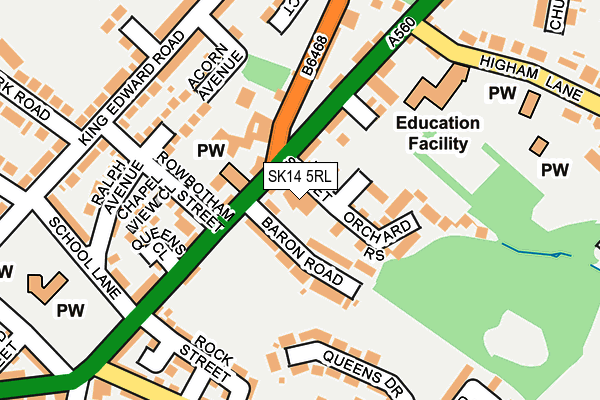
SK14 5RL is located in the Hyde Werneth electoral ward, within the metropolitan district of Tameside and the English Parliamentary constituency of Stalybridge and Hyde. The Sub Integrated Care Board (ICB) Location is NHS Greater Manchester ICB - 01Y and the police force is Greater Manchester. This postcode has been in use since January 1980.


GetTheData
Source: OS OpenMap – Local (Ordnance Survey)
Source: OS VectorMap District (Ordnance Survey)
Licence: Open Government Licence (requires attribution)
| Easting | 395565 |
| Northing | 393506 |
| Latitude | 53.438311 |
| Longitude | -2.068228 |
GetTheData
Source: Open Postcode Geo
Licence: Open Government Licence
| Country | England |
| Postcode District | SK14 |
| ➜ SK14 open data dashboard ➜ See where SK14 is on a map ➜ Where is Hyde? | |
GetTheData
Source: Land Registry Price Paid Data
Licence: Open Government Licence
Elevation or altitude of SK14 5RL as distance above sea level:
| Metres | Feet | |
|---|---|---|
| Elevation | 160m | 525ft |
Elevation is measured from the approximate centre of the postcode, to the nearest point on an OS contour line from OS Terrain 50, which has contour spacing of ten vertical metres.
➜ How high above sea level am I? Find the elevation of your current position using your device's GPS.
GetTheData
Source: Open Postcode Elevation
Licence: Open Government Licence
| Ward | Hyde Werneth |
| Constituency | Stalybridge And Hyde |
GetTheData
Source: ONS Postcode Database
Licence: Open Government Licence
| June 2022 | Other theft | On or near Hepworth Street | 371m |
| October 2021 | Violence and sexual offences | On or near Shawcross Street | 107m |
| ➜ Get more crime data in our Crime section | |||
GetTheData
Source: data.police.uk
Licence: Open Government Licence
| Stockport Rd/Baron Rd (Stockport Rd) | Gee Cross | 75m |
| Stockport Rd/Mottram Old Rd (Stockport Rd) | Gee Cross | 102m |
| Stockport Rd/Grapes Hotel (Stockport Rd) | Gee Cross | 167m |
| King Edward Rd (Sw Bnd) (King Edward Rd) | Gee Cross | 223m |
| Joel Lane (Se Bnd) (Joel Lane) | Gee Cross | 236m |
| Godley Station | 1.7km |
| Hyde Central Station | 1.9km |
| Woodley Station | 1.9km |
GetTheData
Source: NaPTAN
Licence: Open Government Licence
GetTheData
Source: ONS Postcode Database
Licence: Open Government Licence


➜ Get more ratings from the Food Standards Agency
GetTheData
Source: Food Standards Agency
Licence: FSA terms & conditions
| Last Collection | |||
|---|---|---|---|
| Location | Mon-Fri | Sat | Distance |
| Stockport Road | 17:30 | 12:00 | 199m |
| Slateacre Road | 17:45 | 11:45 | 295m |
| Lilly Street | 17:30 | 11:30 | 391m |
GetTheData
Source: Dracos
Licence: Creative Commons Attribution-ShareAlike
| Facility | Distance |
|---|---|
| Dowson Primary Academy Marlborough Road, Hyde Grass Pitches | 394m |
| Alder Community High School Mottram Old Road, Hyde Sports Hall, Health and Fitness Gym, Artificial Grass Pitch, Grass Pitches, Studio | 643m |
| Hyde Cricket And Squash Club Werneth Low Road, Hyde Grass Pitches, Squash Courts, Sports Hall | 868m |
GetTheData
Source: Active Places
Licence: Open Government Licence
| School | Phase of Education | Distance |
|---|---|---|
| Gee Cross Holy Trinity CofE (VC) Primary School Higham Lane, Gee Cross, Hyde, SK14 5LX | Primary | 192m |
| Dowson Primary Academy Marlborough Road, Hyde, SK14 5HU | Primary | 394m |
| Alder Community High School Mottram Old Road, Gee Cross, Hyde, SK14 5NJ | Secondary | 603m |
GetTheData
Source: Edubase
Licence: Open Government Licence
The below table lists the International Territorial Level (ITL) codes (formerly Nomenclature of Territorial Units for Statistics (NUTS) codes) and Local Administrative Units (LAU) codes for SK14 5RL:
| ITL 1 Code | Name |
|---|---|
| TLD | North West (England) |
| ITL 2 Code | Name |
| TLD3 | Greater Manchester |
| ITL 3 Code | Name |
| TLD35 | Greater Manchester South East |
| LAU 1 Code | Name |
| E08000008 | Tameside |
GetTheData
Source: ONS Postcode Directory
Licence: Open Government Licence
The below table lists the Census Output Area (OA), Lower Layer Super Output Area (LSOA), and Middle Layer Super Output Area (MSOA) for SK14 5RL:
| Code | Name | |
|---|---|---|
| OA | E00030617 | |
| LSOA | E01006042 | Tameside 030A |
| MSOA | E02001258 | Tameside 030 |
GetTheData
Source: ONS Postcode Directory
Licence: Open Government Licence
| SK14 5RW | Baron Road | 56m |
| SK14 5NQ | Harrison Street | 74m |
| SK14 5RJ | Harrison Street | 75m |
| SK14 5SB | Orchard Rise | 88m |
| SK14 5NH | Shawcross Street | 102m |
| SK14 5NG | Mottram Old Road | 117m |
| SK14 5RT | Wrigley Square | 120m |
| SK14 5RF | Stockport Road | 121m |
| SK14 5RP | Rowbotham Street | 133m |
| SK14 5PR | Shawcross Street | 138m |
GetTheData
Source: Open Postcode Geo; Land Registry Price Paid Data
Licence: Open Government Licence