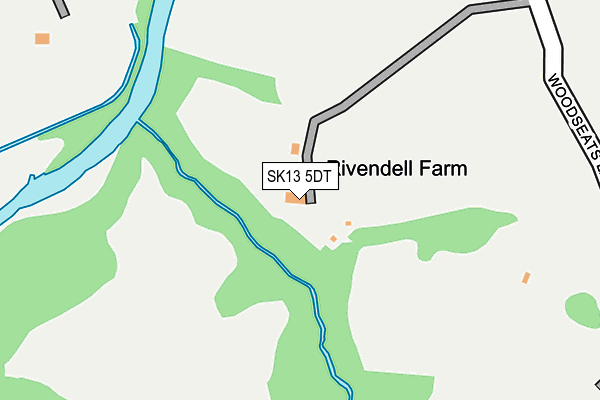
SK13 5DT lies on Rose Grove in Charlesworth, Glossop. SK13 5DT is located in the St John's electoral ward, within the local authority district of High Peak and the English Parliamentary constituency of High Peak. The Sub Integrated Care Board (ICB) Location is NHS Derby and Derbyshire ICB - 15M and the police force is Derbyshire. This postcode has been in use since December 1997.


GetTheData
Source: OS OpenMap – Local (Ordnance Survey)
Source: OS VectorMap District (Ordnance Survey)
Licence: Open Government Licence (requires attribution)
| Easting | 398962 |
| Northing | 393142 |
| Latitude | 53.435074 |
| Longitude | -2.017089 |
GetTheData
Source: Open Postcode Geo
Licence: Open Government Licence
| Street | Rose Grove |
| Locality | Charlesworth |
| Town/City | Glossop |
| Country | England |
| Postcode District | SK13 |
| ➜ SK13 open data dashboard ➜ See where SK13 is on a map | |
GetTheData
Source: Land Registry Price Paid Data
Licence: Open Government Licence
Elevation or altitude of SK13 5DT as distance above sea level:
| Metres | Feet | |
|---|---|---|
| Elevation | 110m | 361ft |
Elevation is measured from the approximate centre of the postcode, to the nearest point on an OS contour line from OS Terrain 50, which has contour spacing of ten vertical metres.
➜ How high above sea level am I? Find the elevation of your current position using your device's GPS.
GetTheData
Source: Open Postcode Elevation
Licence: Open Government Licence
| Ward | St John's |
| Constituency | High Peak |
GetTheData
Source: ONS Postcode Database
Licence: Open Government Licence
| Mottram Rd/Broadbottom Stn (Broadbottom Rd) | Broadbottom | 676m |
| Mottram Rd/Broadbottom Stn (Mottram Rd) | Broadbottom | 690m |
| Market St/Mill Brow (Market St) | Broadbottom | 761m |
| Market St/Gorsey Brow (Market St) | Broadbottom | 778m |
| Lower Market St/Bostock Rd (Lower Market St) | Broadbottom | 792m |
| Broadbottom Station | 0.7km |
| Hattersley Station | 1.9km |
| Godley Station | 3.1km |
GetTheData
Source: NaPTAN
Licence: Open Government Licence
| Percentage of properties with Next Generation Access | 100.0% |
| Percentage of properties with Superfast Broadband | 0.0% |
| Percentage of properties with Ultrafast Broadband | 0.0% |
| Percentage of properties with Full Fibre Broadband | 0.0% |
Superfast Broadband is between 30Mbps and 300Mbps
Ultrafast Broadband is > 300Mbps
| Percentage of properties unable to receive 2Mbps | 0.0% |
| Percentage of properties unable to receive 5Mbps | 0.0% |
| Percentage of properties unable to receive 10Mbps | 50.0% |
| Percentage of properties unable to receive 30Mbps | 100.0% |
GetTheData
Source: Ofcom
Licence: Ofcom Terms of Use (requires attribution)
GetTheData
Source: ONS Postcode Database
Licence: Open Government Licence


➜ Get more ratings from the Food Standards Agency
GetTheData
Source: Food Standards Agency
Licence: FSA terms & conditions
| Last Collection | |||
|---|---|---|---|
| Location | Mon-Fri | Sat | Distance |
| Mottram Road | 17:00 | 12:00 | 682m |
| 52 Market Street | 17:15 | 12:00 | 771m |
| Hunters Pub | 16:50 | 11:45 | 1,114m |
GetTheData
Source: Dracos
Licence: Creative Commons Attribution-ShareAlike
| Facility | Distance |
|---|---|
| Active Etherow (Closed) Market Street, Broadbottom, Hyde Indoor Bowls | 689m |
| Broadbottom C Of E Primary School Mottram Road, Broadbottom, Hyde Grass Pitches | 732m |
| Broadbottom Cricket Club Hill End, Mottram Road, Hyde Grass Pitches | 841m |
GetTheData
Source: Active Places
Licence: Open Government Licence
| School | Phase of Education | Distance |
|---|---|---|
| Broadbottom Church of England Primary School Mottram Road, Broadbottom, Hyde, SK14 6BB | Primary | 732m |
| Charlesworth Voluntary Controlled Primary School Charlesworth Voluntary Controlled Primary School, Long Lane, Charlesworth, Glossop, SK13 5ET | Primary | 1.5km |
| Pinfold Primary School Hattersley Road East, Hattersley, Hyde, SK14 3NL | Primary | 1.6km |
GetTheData
Source: Edubase
Licence: Open Government Licence
The below table lists the International Territorial Level (ITL) codes (formerly Nomenclature of Territorial Units for Statistics (NUTS) codes) and Local Administrative Units (LAU) codes for SK13 5DT:
| ITL 1 Code | Name |
|---|---|
| TLF | East Midlands (England) |
| ITL 2 Code | Name |
| TLF1 | Derbyshire and Nottinghamshire |
| ITL 3 Code | Name |
| TLF13 | South and West Derbyshire |
| LAU 1 Code | Name |
| E07000037 | High Peak |
GetTheData
Source: ONS Postcode Directory
Licence: Open Government Licence
The below table lists the Census Output Area (OA), Lower Layer Super Output Area (LSOA), and Middle Layer Super Output Area (MSOA) for SK13 5DT:
| Code | Name | |
|---|---|---|
| OA | E00099948 | |
| LSOA | E01019754 | High Peak 004C |
| MSOA | E02004096 | High Peak 004 |
GetTheData
Source: ONS Postcode Directory
Licence: Open Government Licence
| SK13 5DS | Woodseats Lane | 325m |
| SK14 6BN | Leylands Cottages | 454m |
| SK13 5RS | Far Woodseats Lane | 480m |
| SK14 6BD | Moss Lane | 547m |
| SK14 6BP | Summerbottom | 590m |
| SK13 5DR | Woodseats Lane | 603m |
| SK14 6BJ | Coombes View | 612m |
| SK14 6AR | Well Row | 668m |
| SK14 6AS | Old Street | 682m |
| SK14 6BB | Mottram Road | 697m |
GetTheData
Source: Open Postcode Geo; Land Registry Price Paid Data
Licence: Open Government Licence