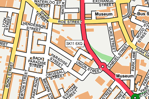
SK11 6XQ is located in the Macclesfield Central electoral ward, within the unitary authority of Cheshire East and the English Parliamentary constituency of Macclesfield. The Sub Integrated Care Board (ICB) Location is NHS Cheshire and Merseyside ICB - 27D and the police force is Cheshire. This postcode has been in use since April 2005.


GetTheData
Source: OS OpenMap – Local (Ordnance Survey)
Source: OS VectorMap District (Ordnance Survey)
Licence: Open Government Licence (requires attribution)
| Easting | 391520 |
| Northing | 373291 |
| Latitude | 53.256573 |
| Longitude | -2.128566 |
GetTheData
Source: Open Postcode Geo
Licence: Open Government Licence
| Country | England |
| Postcode District | SK11 |
| ➜ SK11 open data dashboard ➜ See where SK11 is on a map ➜ Where is Macclesfield? | |
GetTheData
Source: Land Registry Price Paid Data
Licence: Open Government Licence
Elevation or altitude of SK11 6XQ as distance above sea level:
| Metres | Feet | |
|---|---|---|
| Elevation | 140m | 459ft |
Elevation is measured from the approximate centre of the postcode, to the nearest point on an OS contour line from OS Terrain 50, which has contour spacing of ten vertical metres.
➜ How high above sea level am I? Find the elevation of your current position using your device's GPS.
GetTheData
Source: Open Postcode Elevation
Licence: Open Government Licence
| Ward | Macclesfield Central |
| Constituency | Macclesfield |
GetTheData
Source: ONS Postcode Database
Licence: Open Government Licence
| December 2023 | Criminal damage and arson | On or near Cholmondeley Street | 429m |
| July 2023 | Burglary | On or near Paradise Street | 85m |
| June 2023 | Other theft | On or near Paradise Street | 85m |
| ➜ Get more crime data in our Crime section | |||
GetTheData
Source: data.police.uk
Licence: Open Government Licence
| Tesco (Churchill Way) | Macclesfield | 182m |
| Tesco (Churchill Way) | Macclesfield | 192m |
| Henderson Street (Bond Street) | Macclesfield | 249m |
| Henderson Street (Bond Street) | Macclesfield | 250m |
| Brown Street (Park Lane) | Macclesfield | 297m |
| Macclesfield Station | 0.5km |
| Prestbury Station | 4.2km |
GetTheData
Source: NaPTAN
Licence: Open Government Licence
GetTheData
Source: ONS Postcode Database
Licence: Open Government Licence


➜ Get more ratings from the Food Standards Agency
GetTheData
Source: Food Standards Agency
Licence: FSA terms & conditions
| Last Collection | |||
|---|---|---|---|
| Location | Mon-Fri | Sat | Distance |
| Elisebeth Street | 17:30 | 12:30 | 36m |
| Duke Street | 18:30 | 12:00 | 182m |
| Bond Street | 18:15 | 12:15 | 248m |
GetTheData
Source: Dracos
Licence: Creative Commons Attribution-ShareAlike
| Facility | Distance |
|---|---|
| Anytime Fitness (Macclesfield) Duke Street, Duke Street, Macclesfield Health and Fitness Gym | 179m |
| Louis Gym Park Lane , Macclesfield Health and Fitness Gym, Studio | 335m |
| Everlast Gyms (Macclesfield) Pickford Street, Macclesfield Swimming Pool, Health and Fitness Gym, Studio | 349m |
GetTheData
Source: Active Places
Licence: Open Government Licence
| School | Phase of Education | Distance |
|---|---|---|
| Parkroyal Community School Lyon Street, Macclesfield, SK11 6QX | Primary | 352m |
| The Fermain Academy Beswick Street, Macclesfield, SK11 8JF | Not applicable | 678m |
| All Hallows Catholic College Brooklands Avenue, Macclesfield, SK11 8LB | Secondary | 859m |
GetTheData
Source: Edubase
Licence: Open Government Licence
The below table lists the International Territorial Level (ITL) codes (formerly Nomenclature of Territorial Units for Statistics (NUTS) codes) and Local Administrative Units (LAU) codes for SK11 6XQ:
| ITL 1 Code | Name |
|---|---|
| TLD | North West (England) |
| ITL 2 Code | Name |
| TLD6 | Cheshire |
| ITL 3 Code | Name |
| TLD62 | Cheshire East |
| LAU 1 Code | Name |
| E06000049 | Cheshire East |
GetTheData
Source: ONS Postcode Directory
Licence: Open Government Licence
The below table lists the Census Output Area (OA), Lower Layer Super Output Area (LSOA), and Middle Layer Super Output Area (MSOA) for SK11 6XQ:
| Code | Name | |
|---|---|---|
| OA | E00093991 | |
| LSOA | E01018624 | Cheshire East 018C |
| MSOA | E02003870 | Cheshire East 018 |
GetTheData
Source: ONS Postcode Directory
Licence: Open Government Licence
| SK11 6XP | Elizabeth Street | 43m |
| SK11 6QN | Paradise Street | 58m |
| SK11 6QW | Holland Street | 89m |
| SK11 6XN | Statham Street | 99m |
| SK11 6QF | Crossall Street | 108m |
| SK11 6QE | Bridge Street | 110m |
| SK11 6XD | Roe Street | 130m |
| SK11 6PZ | Bridge Street | 138m |
| SK11 6QB | Marsden Terrace | 145m |
| SK11 6XL | Statham Street | 146m |
GetTheData
Source: Open Postcode Geo; Land Registry Price Paid Data
Licence: Open Government Licence