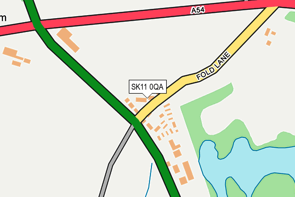
SK11 0QA is located in the Gawsworth electoral ward, within the unitary authority of Cheshire East and the English Parliamentary constituency of Macclesfield. The Sub Integrated Care Board (ICB) Location is NHS Cheshire and Merseyside ICB - 27D and the police force is Cheshire. This postcode has been in use since November 2015.


GetTheData
Source: OS OpenMap – Local (Ordnance Survey)
Source: OS VectorMap District (Ordnance Survey)
Licence: Open Government Licence (requires attribution)
| Easting | 391529 |
| Northing | 366525 |
| Latitude | 53.195756 |
| Longitude | -2.128250 |
GetTheData
Source: Open Postcode Geo
Licence: Open Government Licence
| Country | England |
| Postcode District | SK11 |
| ➜ SK11 open data dashboard ➜ See where SK11 is on a map ➜ Where is Bosley? | |
GetTheData
Source: Land Registry Price Paid Data
Licence: Open Government Licence
Elevation or altitude of SK11 0QA as distance above sea level:
| Metres | Feet | |
|---|---|---|
| Elevation | 180m | 591ft |
Elevation is measured from the approximate centre of the postcode, to the nearest point on an OS contour line from OS Terrain 50, which has contour spacing of ten vertical metres.
➜ How high above sea level am I? Find the elevation of your current position using your device's GPS.
GetTheData
Source: Open Postcode Elevation
Licence: Open Government Licence
| Ward | Gawsworth |
| Constituency | Macclesfield |
GetTheData
Source: ONS Postcode Database
Licence: Open Government Licence
| May 2022 | Public order | On or near Fold Lane | 138m |
| March 2021 | Other theft | On or near Fold Lane | 138m |
| February 2021 | Violence and sexual offences | On or near Fold Lane | 138m |
| ➜ Get more crime data in our Crime section | |||
GetTheData
Source: data.police.uk
Licence: Open Government Licence
| Dene House (London Road) | Bosley | 168m |
| Dene House (London Road) | Bosley | 169m |
| Crossroads (London Road) | Bosley | 235m |
| Crossroads (London Road) | Bosley | 260m |
| Bus Shelter (London Road) | Bosley | 382m |
| Congleton Station | 6km |
GetTheData
Source: NaPTAN
Licence: Open Government Licence
➜ Broadband speed and availability dashboard for SK11 0QA
| Percentage of properties with Next Generation Access | 100.0% |
| Percentage of properties with Superfast Broadband | 100.0% |
| Percentage of properties with Ultrafast Broadband | 0.0% |
| Percentage of properties with Full Fibre Broadband | 0.0% |
Superfast Broadband is between 30Mbps and 300Mbps
Ultrafast Broadband is > 300Mbps
| Median download speed | 51.2Mbps |
| Average download speed | 52.4Mbps |
| Maximum download speed | 79.04Mbps |
| Median upload speed | 18.7Mbps |
| Average upload speed | 17.3Mbps |
| Maximum upload speed | 20.00Mbps |
| Percentage of properties unable to receive 2Mbps | 0.0% |
| Percentage of properties unable to receive 5Mbps | 0.0% |
| Percentage of properties unable to receive 10Mbps | 0.0% |
| Percentage of properties unable to receive 30Mbps | 0.0% |
➜ Broadband speed and availability dashboard for SK11 0QA
GetTheData
Source: Ofcom
Licence: Ofcom Terms of Use (requires attribution)
GetTheData
Source: ONS Postcode Database
Licence: Open Government Licence


➜ Get more ratings from the Food Standards Agency
GetTheData
Source: Food Standards Agency
Licence: FSA terms & conditions
| Last Collection | |||
|---|---|---|---|
| Location | Mon-Fri | Sat | Distance |
| Bosley Station | 16:00 | 08:15 | 245m |
| Lakeside | 16:00 | 07:45 | 618m |
| North Rode Station | 16:30 | 07:30 | 1,489m |
GetTheData
Source: Dracos
Licence: Creative Commons Attribution-ShareAlike
| Facility | Distance |
|---|---|
| Gawsworth Primary School Longbutts Lane, Gawsworth, Macclesfield Grass Pitches | 4.7km |
| St Johns Road St Johns Road, Congleton Grass Pitches | 5.2km |
| Buglawton Primary School Buxton Old Road, Congleton Grass Pitches | 5.3km |
GetTheData
Source: Active Places
Licence: Open Government Licence
| School | Phase of Education | Distance |
|---|---|---|
| Bosley St Mary's CofE Primary School Leek Road, Bosley, Macclesfield, SK11 0NX | Primary | 926m |
| Wincle CofE Primary School Wincle, Macclesfield, SK11 0QH | Primary | 4.4km |
| Hollinhey Primary School Bell Avenue, Sutton Lane Ends, Macclesfield, SK11 0EE | Primary | 4.7km |
GetTheData
Source: Edubase
Licence: Open Government Licence
The below table lists the International Territorial Level (ITL) codes (formerly Nomenclature of Territorial Units for Statistics (NUTS) codes) and Local Administrative Units (LAU) codes for SK11 0QA:
| ITL 1 Code | Name |
|---|---|
| TLD | North West (England) |
| ITL 2 Code | Name |
| TLD6 | Cheshire |
| ITL 3 Code | Name |
| TLD62 | Cheshire East |
| LAU 1 Code | Name |
| E06000049 | Cheshire East |
GetTheData
Source: ONS Postcode Directory
Licence: Open Government Licence
The below table lists the Census Output Area (OA), Lower Layer Super Output Area (LSOA), and Middle Layer Super Output Area (MSOA) for SK11 0QA:
| Code | Name | |
|---|---|---|
| OA | E00093815 | |
| LSOA | E01018591 | Cheshire East 020A |
| MSOA | E02003872 | Cheshire East 020 |
GetTheData
Source: ONS Postcode Directory
Licence: Open Government Licence
| SK11 0PN | 138m | |
| SK11 0PS | Buxton Road | 568m |
| SK11 0PL | Lakeside | 628m |
| SK11 0PJ | 652m | |
| SK11 0PP | 765m | |
| SK11 0PH | 784m | |
| SK11 0PT | Brooks Lane | 856m |
| SK11 0NX | 1000m | |
| SK11 0PR | Stoneyfold Lane | 1037m |
| CW12 2PB | 1125m |
GetTheData
Source: Open Postcode Geo; Land Registry Price Paid Data
Licence: Open Government Licence