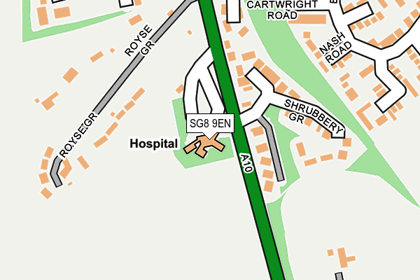
SG8 9EN is located in the Royston Heath electoral ward, within the local authority district of North Hertfordshire and the English Parliamentary constituency of North East Hertfordshire. The Sub Integrated Care Board (ICB) Location is NHS Cambridgeshire and Peterborough ICB - 06H and the police force is Hertfordshire. This postcode has been in use since January 1980.


GetTheData
Source: OS OpenMap – Local (Ordnance Survey)
Source: OS VectorMap District (Ordnance Survey)
Licence: Open Government Licence (requires attribution)
| Easting | 535774 |
| Northing | 239896 |
| Latitude | 52.040855 |
| Longitude | -0.021788 |
GetTheData
Source: Open Postcode Geo
Licence: Open Government Licence
| Country | England |
| Postcode District | SG8 |
| ➜ SG8 open data dashboard ➜ See where SG8 is on a map ➜ Where is Royston? | |
GetTheData
Source: Land Registry Price Paid Data
Licence: Open Government Licence
Elevation or altitude of SG8 9EN as distance above sea level:
| Metres | Feet | |
|---|---|---|
| Elevation | 90m | 295ft |
Elevation is measured from the approximate centre of the postcode, to the nearest point on an OS contour line from OS Terrain 50, which has contour spacing of ten vertical metres.
➜ How high above sea level am I? Find the elevation of your current position using your device's GPS.
GetTheData
Source: Open Postcode Elevation
Licence: Open Government Licence
| Ward | Royston Heath |
| Constituency | North East Hertfordshire |
GetTheData
Source: ONS Postcode Database
Licence: Open Government Licence
| September 2023 | Violence and sexual offences | On or near Layston Park | 310m |
| April 2023 | Vehicle crime | On or near Layston Park | 310m |
| June 2022 | Public order | On or near Hargreaves Road | 274m |
| ➜ Get more crime data in our Crime section | |||
GetTheData
Source: data.police.uk
Licence: Open Government Licence
| Shaftesbury Way (Barkway Road) | Royston | 641m |
| Shaftesbury Way (Barkway Road) | Royston | 649m |
| Recreation Ground (Priory Lane) | Royston | 765m |
| Studlands Rise | Royston | 807m |
| Town Hall (Melbourn Street) | Royston | 816m |
| Royston Station | 1.4km |
GetTheData
Source: NaPTAN
Licence: Open Government Licence
GetTheData
Source: ONS Postcode Database
Licence: Open Government Licence


➜ Get more ratings from the Food Standards Agency
GetTheData
Source: Food Standards Agency
Licence: FSA terms & conditions
| Last Collection | |||
|---|---|---|---|
| Location | Mon-Fri | Sat | Distance |
| Layston Park | 18:00 | 12:00 | 256m |
| Beldam Avenue | 17:00 | 11:45 | 488m |
| Barkway Street | 17:30 | 11:45 | 532m |
GetTheData
Source: Dracos
Licence: Creative Commons Attribution-ShareAlike
| Facility | Distance |
|---|---|
| Bodyworks Gymnasium (Closed) Angel Pavement, Royston Health and Fitness Gym | 635m |
| Studlands Rise Playing Fields Studlands Rise, Royston Grass Pitches, Outdoor Tennis Courts | 696m |
| Studlands Rise First School Studlands Rise, Studlands Rise, Royston Grass Pitches | 751m |
GetTheData
Source: Active Places
Licence: Open Government Licence
| School | Phase of Education | Distance |
|---|---|---|
| Studlands Rise First School Studlands Rise, Royston, SG8 9HB | Primary | 754m |
| Tannery Drift School Tannery Drift, Royston, SG8 5DE | Primary | 1.1km |
| St Mary Roman Catholic Primary School Melbourn Road, Royston, SG8 7DB | Primary | 1.2km |
GetTheData
Source: Edubase
Licence: Open Government Licence
The below table lists the International Territorial Level (ITL) codes (formerly Nomenclature of Territorial Units for Statistics (NUTS) codes) and Local Administrative Units (LAU) codes for SG8 9EN:
| ITL 1 Code | Name |
|---|---|
| TLH | East |
| ITL 2 Code | Name |
| TLH2 | Bedfordshire and Hertfordshire |
| ITL 3 Code | Name |
| TLH23 | Hertfordshire CC |
| LAU 1 Code | Name |
| E07000099 | North Hertfordshire |
GetTheData
Source: ONS Postcode Directory
Licence: Open Government Licence
The below table lists the Census Output Area (OA), Lower Layer Super Output Area (LSOA), and Middle Layer Super Output Area (MSOA) for SG8 9EN:
| Code | Name | |
|---|---|---|
| OA | E00120127 | |
| LSOA | E01023655 | North Hertfordshire 002B |
| MSOA | E02004910 | North Hertfordshire 002 |
GetTheData
Source: ONS Postcode Directory
Licence: Open Government Licence
| SG8 9LJ | Shrubbery Grove | 116m |
| SG8 9EL | London Road | 142m |
| SG8 9EP | Royse Grove | 161m |
| SG8 9UB | Hampden Rise | 208m |
| SG8 9UA | Nash Road | 220m |
| SG8 9UD | Mill Hill | 249m |
| SG8 9ET | Cartwright Road | 257m |
| SG8 9UN | Hargreaves Road | 280m |
| SG8 9UE | Wortham Road | 285m |
| SG8 9LU | London Road | 291m |
GetTheData
Source: Open Postcode Geo; Land Registry Price Paid Data
Licence: Open Government Licence