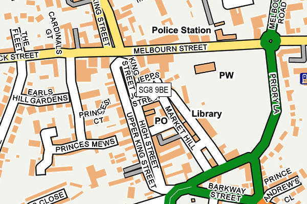
SG8 9BE is located in the Royston Palace electoral ward, within the local authority district of North Hertfordshire and the English Parliamentary constituency of North East Hertfordshire. The Sub Integrated Care Board (ICB) Location is NHS Cambridgeshire and Peterborough ICB - 06H and the police force is Hertfordshire. This postcode has been in use since January 1980.


GetTheData
Source: OS OpenMap – Local (Ordnance Survey)
Source: OS VectorMap District (Ordnance Survey)
Licence: Open Government Licence (requires attribution)
| Easting | 535661 |
| Northing | 240608 |
| Latitude | 52.047270 |
| Longitude | -0.023181 |
GetTheData
Source: Open Postcode Geo
Licence: Open Government Licence
| Country | England |
| Postcode District | SG8 |
| ➜ SG8 open data dashboard ➜ See where SG8 is on a map ➜ Where is Royston? | |
GetTheData
Source: Land Registry Price Paid Data
Licence: Open Government Licence
Elevation or altitude of SG8 9BE as distance above sea level:
| Metres | Feet | |
|---|---|---|
| Elevation | 70m | 230ft |
Elevation is measured from the approximate centre of the postcode, to the nearest point on an OS contour line from OS Terrain 50, which has contour spacing of ten vertical metres.
➜ How high above sea level am I? Find the elevation of your current position using your device's GPS.
GetTheData
Source: Open Postcode Elevation
Licence: Open Government Licence
| Ward | Royston Palace |
| Constituency | North East Hertfordshire |
GetTheData
Source: ONS Postcode Database
Licence: Open Government Licence
| January 2024 | Anti-social behaviour | On or near Jepps Lane | 36m |
| December 2023 | Criminal damage and arson | On or near Jepps Lane | 36m |
| December 2023 | Violence and sexual offences | On or near Jepps Lane | 36m |
| ➜ Get more crime data in our Crime section | |||
GetTheData
Source: data.police.uk
Licence: Open Government Licence
| Town Hall (Melbourn Street) | Royston | 148m |
| Morrisons (Baldock Street) | Royston | 168m |
| Town Hall (Melbourn Street) | Royston | 217m |
| Recreation Ground (Priory Lane) | Royston | 228m |
| Fire Station (Baldock Street) | Royston | 336m |
| Royston Station | 0.7km |
| Meldreth Station | 5.3km |
GetTheData
Source: NaPTAN
Licence: Open Government Licence
GetTheData
Source: ONS Postcode Database
Licence: Open Government Licence


➜ Get more ratings from the Food Standards Agency
GetTheData
Source: Food Standards Agency
Licence: FSA terms & conditions
| Last Collection | |||
|---|---|---|---|
| Location | Mon-Fri | Sat | Distance |
| Martins Newsagents | 18:00 | 12:30 | 31m |
| The Cross | 17:30 | 11:45 | 148m |
| Barkway Street | 17:30 | 11:45 | 196m |
GetTheData
Source: Dracos
Licence: Creative Commons Attribution-ShareAlike
| Facility | Distance |
|---|---|
| Bodyworks Gymnasium (Closed) Angel Pavement, Royston Health and Fitness Gym | 88m |
| Royston Outdoor Pool (Closed) Newmarket Road, Royston Swimming Pool | 298m |
| Royston Golf Club Baldock Road, Royston Golf | 476m |
GetTheData
Source: Active Places
Licence: Open Government Licence
| School | Phase of Education | Distance |
|---|---|---|
| Tannery Drift School Tannery Drift, Royston, SG8 5DE | Primary | 484m |
| St Mary Roman Catholic Primary School Melbourn Road, Royston, SG8 7DB | Primary | 488m |
| Studlands Rise First School Studlands Rise, Royston, SG8 9HB | Primary | 607m |
GetTheData
Source: Edubase
Licence: Open Government Licence
The below table lists the International Territorial Level (ITL) codes (formerly Nomenclature of Territorial Units for Statistics (NUTS) codes) and Local Administrative Units (LAU) codes for SG8 9BE:
| ITL 1 Code | Name |
|---|---|
| TLH | East |
| ITL 2 Code | Name |
| TLH2 | Bedfordshire and Hertfordshire |
| ITL 3 Code | Name |
| TLH23 | Hertfordshire CC |
| LAU 1 Code | Name |
| E07000099 | North Hertfordshire |
GetTheData
Source: ONS Postcode Directory
Licence: Open Government Licence
The below table lists the Census Output Area (OA), Lower Layer Super Output Area (LSOA), and Middle Layer Super Output Area (MSOA) for SG8 9BE:
| Code | Name | |
|---|---|---|
| OA | E00120159 | |
| LSOA | E01023660 | North Hertfordshire 001A |
| MSOA | E02004909 | North Hertfordshire 001 |
GetTheData
Source: ONS Postcode Directory
Licence: Open Government Licence
| SG8 9JL | Market Hill | 24m |
| SG8 9AG | High Street | 29m |
| SG8 9AA | High Street | 50m |
| SG8 9AP | Jepps Lane | 59m |
| SG8 9AR | George Lane | 59m |
| SG8 9AZ | Upper King Street | 67m |
| SG8 9LG | Church Lane | 72m |
| SG8 7BJ | Melbourn Street | 78m |
| SG8 9WA | King Street | 80m |
| SG8 7BP | Melbourn Street | 91m |
GetTheData
Source: Open Postcode Geo; Land Registry Price Paid Data
Licence: Open Government Licence