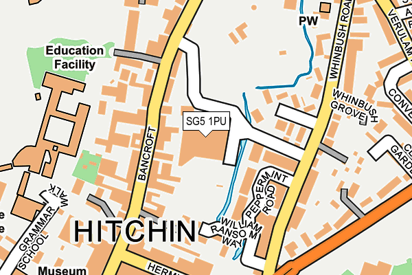
SG5 1PU is located in the Hitchin Bearton electoral ward, within the local authority district of North Hertfordshire and the English Parliamentary constituency of Hitchin and Harpenden. The Sub Integrated Care Board (ICB) Location is NHS Hertfordshire and West Essex ICB - 06K and the police force is Hertfordshire. This postcode has been in use since January 1980.


GetTheData
Source: OS OpenMap – Local (Ordnance Survey)
Source: OS VectorMap District (Ordnance Survey)
Licence: Open Government Licence (requires attribution)
| Easting | 518628 |
| Northing | 229490 |
| Latitude | 51.951268 |
| Longitude | -0.275249 |
GetTheData
Source: Open Postcode Geo
Licence: Open Government Licence
| Country | England |
| Postcode District | SG5 |
| ➜ SG5 open data dashboard ➜ See where SG5 is on a map ➜ Where is Hitchin? | |
GetTheData
Source: Land Registry Price Paid Data
Licence: Open Government Licence
Elevation or altitude of SG5 1PU as distance above sea level:
| Metres | Feet | |
|---|---|---|
| Elevation | 60m | 197ft |
Elevation is measured from the approximate centre of the postcode, to the nearest point on an OS contour line from OS Terrain 50, which has contour spacing of ten vertical metres.
➜ How high above sea level am I? Find the elevation of your current position using your device's GPS.
GetTheData
Source: Open Postcode Elevation
Licence: Open Government Licence
| Ward | Hitchin Bearton |
| Constituency | Hitchin And Harpenden |
GetTheData
Source: ONS Postcode Database
Licence: Open Government Licence
| January 2024 | Burglary | On or near Supermarket | 5m |
| January 2024 | Shoplifting | On or near Supermarket | 5m |
| January 2024 | Shoplifting | On or near Supermarket | 5m |
| ➜ Get more crime data in our Crime section | |||
GetTheData
Source: data.police.uk
Licence: Open Government Licence
| The Phoenix Ph (Bancroft) | Hitchin | 162m |
| Hermitage Road | Hitchin | 197m |
| Hermitage Road | Hitchin | 210m |
| The Phoenix Ph (Bancroft) | Hitchin | 211m |
| Bancroft | Hitchin | 251m |
| Hitchin Station | 0.8km |
| Letchworth Station | 4.5km |
GetTheData
Source: NaPTAN
Licence: Open Government Licence
| Percentage of properties with Next Generation Access | 100.0% |
| Percentage of properties with Superfast Broadband | 100.0% |
| Percentage of properties with Ultrafast Broadband | 100.0% |
| Percentage of properties with Full Fibre Broadband | 0.0% |
Superfast Broadband is between 30Mbps and 300Mbps
Ultrafast Broadband is > 300Mbps
| Percentage of properties unable to receive 2Mbps | 0.0% |
| Percentage of properties unable to receive 5Mbps | 0.0% |
| Percentage of properties unable to receive 10Mbps | 0.0% |
| Percentage of properties unable to receive 30Mbps | 0.0% |
GetTheData
Source: Ofcom
Licence: Ofcom Terms of Use (requires attribution)
GetTheData
Source: ONS Postcode Database
Licence: Open Government Licence


➜ Get more ratings from the Food Standards Agency
GetTheData
Source: Food Standards Agency
Licence: FSA terms & conditions
| Last Collection | |||
|---|---|---|---|
| Location | Mon-Fri | Sat | Distance |
| Bancroft | 18:30 | 12:00 | 97m |
| Hermitage Road | 216m | ||
| Hermitage Road | 19:00 | 12:00 | 217m |
GetTheData
Source: Dracos
Licence: Creative Commons Attribution-ShareAlike
| Facility | Distance |
|---|---|
| Bancroft Recreation Ground Bancroft, Hitchin Outdoor Tennis Courts | 149m |
| Hitchin Boys School Sports Centre Grammar School Walk, Hitchin Sports Hall, Artificial Grass Pitch, Grass Pitches, Studio | 223m |
| Hbs Tennis Club Fishponds Road, Hitchin Outdoor Tennis Courts | 337m |
GetTheData
Source: Active Places
Licence: Open Government Licence
| School | Phase of Education | Distance |
|---|---|---|
| Hitchin Boys' School Grammar School Walk, Hitchin, SG5 1JB | Secondary | 223m |
| York Road Nursery School York Road, Hitchin, SG5 1XA | Nursery | 451m |
| Wilshere-Dacre Junior Academy Fishponds Road, Hitchin, SG5 1NS | Primary | 493m |
GetTheData
Source: Edubase
Licence: Open Government Licence
The below table lists the International Territorial Level (ITL) codes (formerly Nomenclature of Territorial Units for Statistics (NUTS) codes) and Local Administrative Units (LAU) codes for SG5 1PU:
| ITL 1 Code | Name |
|---|---|
| TLH | East |
| ITL 2 Code | Name |
| TLH2 | Bedfordshire and Hertfordshire |
| ITL 3 Code | Name |
| TLH23 | Hertfordshire CC |
| LAU 1 Code | Name |
| E07000099 | North Hertfordshire |
GetTheData
Source: ONS Postcode Directory
Licence: Open Government Licence
The below table lists the Census Output Area (OA), Lower Layer Super Output Area (LSOA), and Middle Layer Super Output Area (MSOA) for SG5 1PU:
| Code | Name | |
|---|---|---|
| OA | E00169662 | |
| LSOA | E01023601 | North Hertfordshire 010A |
| MSOA | E02004918 | North Hertfordshire 010 |
GetTheData
Source: ONS Postcode Directory
Licence: Open Government Licence
| SG5 1NQ | Bancroft | 70m |
| SG5 1RY | Peppermint Road | 83m |
| SG5 1PP | Hazelwood Close | 83m |
| SG5 1LA | Bancroft | 100m |
| SG5 1PR | Hazelwood Close | 111m |
| SG5 1GB | Bancroft | 132m |
| SG5 1NB | Ransom Yard | 137m |
| SG5 1PF | Whinbush Road | 138m |
| SG5 1QX | William Ransom Way | 148m |
| SG5 1JW | Bancroft | 154m |
GetTheData
Source: Open Postcode Geo; Land Registry Price Paid Data
Licence: Open Government Licence