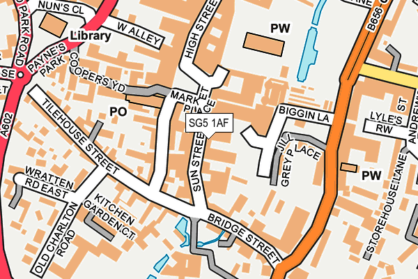
SG5 1AF is located in the Hitchin Highbury electoral ward, within the local authority district of North Hertfordshire and the English Parliamentary constituency of Hitchin and Harpenden. The Sub Integrated Care Board (ICB) Location is NHS Hertfordshire and West Essex ICB - 06K and the police force is Hertfordshire. This postcode has been in use since January 1980.


GetTheData
Source: OS OpenMap – Local (Ordnance Survey)
Source: OS VectorMap District (Ordnance Survey)
Licence: Open Government Licence (requires attribution)
| Easting | 518422 |
| Northing | 228980 |
| Latitude | 51.946721 |
| Longitude | -0.278445 |
GetTheData
Source: Open Postcode Geo
Licence: Open Government Licence
| Country | England |
| Postcode District | SG5 |
| ➜ SG5 open data dashboard ➜ See where SG5 is on a map ➜ Where is Hitchin? | |
GetTheData
Source: Land Registry Price Paid Data
Licence: Open Government Licence
Elevation or altitude of SG5 1AF as distance above sea level:
| Metres | Feet | |
|---|---|---|
| Elevation | 70m | 230ft |
Elevation is measured from the approximate centre of the postcode, to the nearest point on an OS contour line from OS Terrain 50, which has contour spacing of ten vertical metres.
➜ How high above sea level am I? Find the elevation of your current position using your device's GPS.
GetTheData
Source: Open Postcode Elevation
Licence: Open Government Licence
| Ward | Hitchin Highbury |
| Constituency | Hitchin And Harpenden |
GetTheData
Source: ONS Postcode Database
Licence: Open Government Licence
| January 2024 | Anti-social behaviour | On or near Parking Area | 271m |
| January 2024 | Violence and sexual offences | On or near Parking Area | 271m |
| December 2023 | Other theft | On or near Parking Area | 286m |
| ➜ Get more crime data in our Crime section | |||
GetTheData
Source: data.police.uk
Licence: Open Government Licence
| Bridge Street (Queen Street) | Hitchin | 201m |
| St Mary's Square | Hitchin | 216m |
| St Mary's Square | Hitchin | 231m |
| St Mary's Square | Hitchin | 244m |
| St Mary's Square (Queen Street) | Hitchin | 274m |
| Hitchin Station | 1.3km |
| Letchworth Station | 5km |
GetTheData
Source: NaPTAN
Licence: Open Government Licence
GetTheData
Source: ONS Postcode Database
Licence: Open Government Licence


➜ Get more ratings from the Food Standards Agency
GetTheData
Source: Food Standards Agency
Licence: FSA terms & conditions
| Last Collection | |||
|---|---|---|---|
| Location | Mon-Fri | Sat | Distance |
| Market Place | 18:30 | 12:00 | 88m |
| Park Street | 17:30 | 12:00 | 223m |
| Charlton Road | 17:30 | 12:00 | 237m |
GetTheData
Source: Dracos
Licence: Creative Commons Attribution-ShareAlike
| Facility | Distance |
|---|---|
| Fitness Connection (Hitchin) (Closed) Queen Street, Hitchin Health and Fitness Gym, Studio | 175m |
| Xchange Fitness Queen Street, Hitchin Health and Fitness Gym, Studio | 219m |
| Puregym (Hitchin) Brand Street, Hitchin Health and Fitness Gym | 279m |
GetTheData
Source: Active Places
Licence: Open Government Licence
| School | Phase of Education | Distance |
|---|---|---|
| Highbury Infant School and Nursery Standhill Road, Hitchin, SG4 9AG | Primary | 427m |
| Hitchin Boys' School Grammar School Walk, Hitchin, SG5 1JB | Secondary | 494m |
| Hitchin Girls' School Highbury Road, Hitchin, SG4 9RS | Secondary | 635m |
GetTheData
Source: Edubase
Licence: Open Government Licence
The below table lists the International Territorial Level (ITL) codes (formerly Nomenclature of Territorial Units for Statistics (NUTS) codes) and Local Administrative Units (LAU) codes for SG5 1AF:
| ITL 1 Code | Name |
|---|---|
| TLH | East |
| ITL 2 Code | Name |
| TLH2 | Bedfordshire and Hertfordshire |
| ITL 3 Code | Name |
| TLH23 | Hertfordshire CC |
| LAU 1 Code | Name |
| E07000099 | North Hertfordshire |
GetTheData
Source: ONS Postcode Directory
Licence: Open Government Licence
The below table lists the Census Output Area (OA), Lower Layer Super Output Area (LSOA), and Middle Layer Super Output Area (MSOA) for SG5 1AF:
| Code | Name | |
|---|---|---|
| OA | E00119932 | |
| LSOA | E01023616 | North Hertfordshire 012F |
| MSOA | E02004920 | North Hertfordshire 012 |
GetTheData
Source: ONS Postcode Directory
Licence: Open Government Licence
| SG5 1AH | Sun Street | 48m |
| SG5 1BB | Bucklersbury | 63m |
| SG5 1BG | Bucklersbury | 82m |
| SG5 2DJ | Bridge Street | 104m |
| SG5 1DR | Market Place | 105m |
| SG4 9YH | Jill Grey Place | 111m |
| SG5 2DU | Tilehouse Street | 121m |
| SG5 1ED | The Arcade | 136m |
| SG5 2DE | Bridge Street | 140m |
| SG5 2DW | Tilehouse Street | 149m |
GetTheData
Source: Open Postcode Geo; Land Registry Price Paid Data
Licence: Open Government Licence