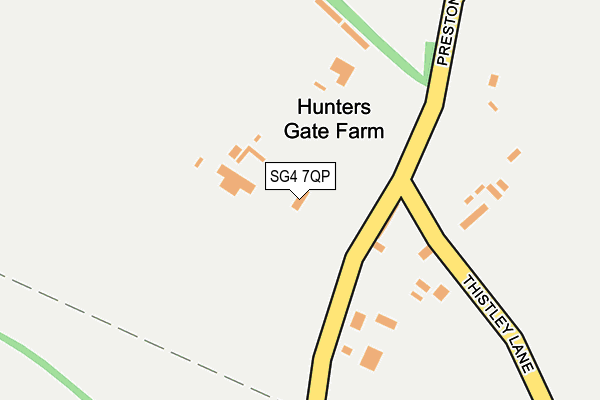
SG4 7QP lies on Preston Road in Gosmore, Hitchin. SG4 7QP is located in the Hitchwood, Offa and Hoo electoral ward, within the local authority district of North Hertfordshire and the English Parliamentary constituency of Hitchin and Harpenden. The Sub Integrated Care Board (ICB) Location is NHS Hertfordshire and West Essex ICB - 06K and the police force is Hertfordshire. This postcode has been in use since January 1980.


GetTheData
Source: OS OpenMap – Local (Ordnance Survey)
Source: OS VectorMap District (Ordnance Survey)
Licence: Open Government Licence (requires attribution)
| Easting | 518620 |
| Northing | 226599 |
| Latitude | 51.925287 |
| Longitude | -0.276363 |
GetTheData
Source: Open Postcode Geo
Licence: Open Government Licence
| Street | Preston Road |
| Locality | Gosmore |
| Town/City | Hitchin |
| Country | England |
| Postcode District | SG4 |
| ➜ SG4 open data dashboard ➜ See where SG4 is on a map | |
GetTheData
Source: Land Registry Price Paid Data
Licence: Open Government Licence
Elevation or altitude of SG4 7QP as distance above sea level:
| Metres | Feet | |
|---|---|---|
| Elevation | 90m | 295ft |
Elevation is measured from the approximate centre of the postcode, to the nearest point on an OS contour line from OS Terrain 50, which has contour spacing of ten vertical metres.
➜ How high above sea level am I? Find the elevation of your current position using your device's GPS.
GetTheData
Source: Open Postcode Elevation
Licence: Open Government Licence
| Ward | Hitchwood, Offa And Hoo |
| Constituency | Hitchin And Harpenden |
GetTheData
Source: ONS Postcode Database
Licence: Open Government Licence
| Thistley Lane (Preston Rd) | Gosmore | 81m |
| Thistley Lane (Preston Rd) | Gosmore | 130m |
| Tatmore Place (Preston Road) | Gosmore | 423m |
| Tatmore Place (Preston Road) | Gosmore | 437m |
| Bird In Hand Ph (High Street) | Gosmore | 540m |
| Hitchin Station | 3.2km |
| Stevenage Station | 5.4km |
GetTheData
Source: NaPTAN
Licence: Open Government Licence
| Percentage of properties with Next Generation Access | 100.0% |
| Percentage of properties with Superfast Broadband | 0.0% |
| Percentage of properties with Ultrafast Broadband | 0.0% |
| Percentage of properties with Full Fibre Broadband | 0.0% |
Superfast Broadband is between 30Mbps and 300Mbps
Ultrafast Broadband is > 300Mbps
| Percentage of properties unable to receive 2Mbps | 0.0% |
| Percentage of properties unable to receive 5Mbps | 0.0% |
| Percentage of properties unable to receive 10Mbps | 0.0% |
| Percentage of properties unable to receive 30Mbps | 100.0% |
GetTheData
Source: Ofcom
Licence: Ofcom Terms of Use (requires attribution)
GetTheData
Source: ONS Postcode Database
Licence: Open Government Licence


➜ Get more ratings from the Food Standards Agency
GetTheData
Source: Food Standards Agency
Licence: FSA terms & conditions
| Last Collection | |||
|---|---|---|---|
| Location | Mon-Fri | Sat | Distance |
| Tatmore Place | 16:45 | 07:45 | 431m |
| Gosmore | 17:00 | 09:00 | 567m |
| St Ippolyts | 17:00 | 08:45 | 860m |
GetTheData
Source: Dracos
Licence: Creative Commons Attribution-ShareAlike
| Facility | Distance |
|---|---|
| Saint Ippolyts Recreation Ground Orchard Close , St. Ippolyts, Hitchin Grass Pitches | 633m |
| The Princess Helena College (Closed) Preston, Hitchin Health and Fitness Gym, Grass Pitches, Sports Hall, Swimming Pool, Studio | 1.8km |
| Whitehill Junior School Whitehill Road, Hitchin Grass Pitches | 1.9km |
GetTheData
Source: Active Places
Licence: Open Government Licence
| School | Phase of Education | Distance |
|---|---|---|
| St Ippolyts Church of England Aided Primary School Ashbrook Lane, Hitchin, SG4 7PB | Primary | 1.3km |
| Kingshott School Stevenage Road, St Ippolyts, Hitchin, SG4 7JX | Not applicable | 1.9km |
| Whitehill Junior School Whitehill Road, Hitchin, SG4 9HT | Primary | 1.9km |
GetTheData
Source: Edubase
Licence: Open Government Licence
The below table lists the International Territorial Level (ITL) codes (formerly Nomenclature of Territorial Units for Statistics (NUTS) codes) and Local Administrative Units (LAU) codes for SG4 7QP:
| ITL 1 Code | Name |
|---|---|
| TLH | East |
| ITL 2 Code | Name |
| TLH2 | Bedfordshire and Hertfordshire |
| ITL 3 Code | Name |
| TLH23 | Hertfordshire CC |
| LAU 1 Code | Name |
| E07000099 | North Hertfordshire |
GetTheData
Source: ONS Postcode Directory
Licence: Open Government Licence
The below table lists the Census Output Area (OA), Lower Layer Super Output Area (LSOA), and Middle Layer Super Output Area (MSOA) for SG4 7QP:
| Code | Name | |
|---|---|---|
| OA | E00119968 | |
| LSOA | E01023622 | North Hertfordshire 014B |
| MSOA | E02004922 | North Hertfordshire 014 |
GetTheData
Source: ONS Postcode Directory
Licence: Open Government Licence
| SG4 7QT | Thistley Lane | 176m |
| SG4 7QD | Maydencroft Lane | 469m |
| SG4 7QS | Preston Road | 493m |
| SG4 7QB | Maydencroft Lane | 517m |
| SG4 7QG | High Street | 526m |
| SG4 7QZ | Waterdell Lane | 531m |
| SG4 7QA | Maydencroft Lane | 581m |
| SG4 7RH | Orchard Close | 605m |
| SG4 7QQ | High Street | 607m |
| SG4 7QR | Preston Road | 615m |
GetTheData
Source: Open Postcode Geo; Land Registry Price Paid Data
Licence: Open Government Licence