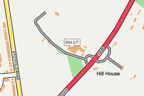
SG4 0JT is located in the Hitchin Walsworth electoral ward, within the local authority district of North Hertfordshire and the English Parliamentary constituency of Hitchin and Harpenden. The Sub Integrated Care Board (ICB) Location is NHS Hertfordshire and West Essex ICB - 06K and the police force is Hertfordshire. This postcode has been in use since January 1980.


GetTheData
Source: OS OpenMap – Local (Ordnance Survey)
Source: OS VectorMap District (Ordnance Survey)
Licence: Open Government Licence (requires attribution)
| Easting | 520567 |
| Northing | 230826 |
| Latitude | 51.962850 |
| Longitude | -0.246605 |
GetTheData
Source: Open Postcode Geo
Licence: Open Government Licence
| Country | England |
| Postcode District | SG4 |
| ➜ SG4 open data dashboard ➜ See where SG4 is on a map | |
GetTheData
Source: Land Registry Price Paid Data
Licence: Open Government Licence
Elevation or altitude of SG4 0JT as distance above sea level:
| Metres | Feet | |
|---|---|---|
| Elevation | 90m | 295ft |
Elevation is measured from the approximate centre of the postcode, to the nearest point on an OS contour line from OS Terrain 50, which has contour spacing of ten vertical metres.
➜ How high above sea level am I? Find the elevation of your current position using your device's GPS.
GetTheData
Source: Open Postcode Elevation
Licence: Open Government Licence
| Ward | Hitchin Walsworth |
| Constituency | Hitchin And Harpenden |
GetTheData
Source: ONS Postcode Database
Licence: Open Government Licence
| June 2022 | Anti-social behaviour | On or near Frensham Drive | 400m |
| May 2022 | Violence and sexual offences | On or near Frensham Drive | 400m |
| May 2022 | Violence and sexual offences | On or near Frensham Drive | 400m |
| ➜ Get more crime data in our Crime section | |||
GetTheData
Source: data.police.uk
Licence: Open Government Licence
| Rosehill Hospital (Cambridge Road) | Letchworth | 229m |
| Rosehill Hospital (Cambridge Road) | Letchworth | 261m |
| Queenswood Drive (Cambridge Road) | Hitchin | 471m |
| Queenswood Drive (Cambridge Road) | Hitchin | 490m |
| Willian Road (Kingswood Avenue) | Purwell | 719m |
| Hitchin Station | 1.6km |
| Letchworth Station | 2.2km |
| Baldock Station | 5.3km |
GetTheData
Source: NaPTAN
Licence: Open Government Licence
GetTheData
Source: ONS Postcode Database
Licence: Open Government Licence


➜ Get more ratings from the Food Standards Agency
GetTheData
Source: Food Standards Agency
Licence: FSA terms & conditions
| Last Collection | |||
|---|---|---|---|
| Location | Mon-Fri | Sat | Distance |
| Queenswood Drive | 17:30 | 12:00 | 422m |
| Grovelands Avenue | 17:30 | 12:00 | 523m |
| Bradleys Corner | 17:30 | 12:00 | 804m |
GetTheData
Source: Dracos
Licence: Creative Commons Attribution-ShareAlike
| Facility | Distance |
|---|---|
| Highover Jmi School And Nursery Cambridge Road, Hitchin Grass Pitches, Sports Hall | 703m |
| The Highfield School Highfield, Letchworth Garden City Sports Hall, Grass Pitches, Outdoor Tennis Courts | 743m |
| Purwell Primary School Fairfield Way, Hitchin Grass Pitches | 1km |
GetTheData
Source: Active Places
Licence: Open Government Licence
| School | Phase of Education | Distance |
|---|---|---|
| North Herts Education Support Centre Briar Patch Lane, Letchworth Garden City, SG6 3LY | Not applicable | 657m |
| Highover Junior Mixed and Infant School Cambridge Road, Hitchin, SG4 0JP | Primary | 702m |
| The Highfield School Highfield, Letchworth Garden City, SG6 3QA | Secondary | 744m |
GetTheData
Source: Edubase
Licence: Open Government Licence
The below table lists the International Territorial Level (ITL) codes (formerly Nomenclature of Territorial Units for Statistics (NUTS) codes) and Local Administrative Units (LAU) codes for SG4 0JT:
| ITL 1 Code | Name |
|---|---|
| TLH | East |
| ITL 2 Code | Name |
| TLH2 | Bedfordshire and Hertfordshire |
| ITL 3 Code | Name |
| TLH23 | Hertfordshire CC |
| LAU 1 Code | Name |
| E07000099 | North Hertfordshire |
GetTheData
Source: ONS Postcode Directory
Licence: Open Government Licence
The below table lists the Census Output Area (OA), Lower Layer Super Output Area (LSOA), and Middle Layer Super Output Area (MSOA) for SG4 0JT:
| Code | Name | |
|---|---|---|
| OA | E00119963 | |
| LSOA | E01023617 | North Hertfordshire 011A |
| MSOA | E02004919 | North Hertfordshire 011 |
GetTheData
Source: ONS Postcode Directory
Licence: Open Government Licence
| SG4 0JU | Cambridge Road | 227m |
| SG4 0QW | Stotfold Road | 268m |
| SG4 0RA | Grovelands Avenue | 301m |
| SG4 0RD | Roundwood Close | 307m |
| SG6 3NA | Hitchin Road | 317m |
| SG4 0QN | Stotfold Road | 322m |
| SG4 0QL | Harkness Way | 363m |
| SG4 0QZ | Grovelands Avenue | 369m |
| SG4 0RE | Collison Close | 377m |
| SG4 0QP | Frensham Drive | 423m |
GetTheData
Source: Open Postcode Geo; Land Registry Price Paid Data
Licence: Open Government Licence