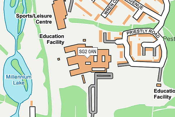
SG2 0AN is located in the Chells electoral ward, within the local authority district of Stevenage and the English Parliamentary constituency of Stevenage. The Sub Integrated Care Board (ICB) Location is NHS Hertfordshire and West Essex ICB - 06K and the police force is Hertfordshire. This postcode has been in use since January 1980.


GetTheData
Source: OS OpenMap – Local (Ordnance Survey)
Source: OS VectorMap District (Ordnance Survey)
Licence: Open Government Licence (requires attribution)
| Easting | 525604 |
| Northing | 224396 |
| Latitude | 51.903954 |
| Longitude | -0.175678 |
GetTheData
Source: Open Postcode Geo
Licence: Open Government Licence
| Country | England |
| Postcode District | SG2 |
| ➜ SG2 open data dashboard ➜ See where SG2 is on a map ➜ Where is Stevenage? | |
GetTheData
Source: Land Registry Price Paid Data
Licence: Open Government Licence
Elevation or altitude of SG2 0AN as distance above sea level:
| Metres | Feet | |
|---|---|---|
| Elevation | 120m | 394ft |
Elevation is measured from the approximate centre of the postcode, to the nearest point on an OS contour line from OS Terrain 50, which has contour spacing of ten vertical metres.
➜ How high above sea level am I? Find the elevation of your current position using your device's GPS.
GetTheData
Source: Open Postcode Elevation
Licence: Open Government Licence
| Ward | Chells |
| Constituency | Stevenage |
GetTheData
Source: ONS Postcode Database
Licence: Open Government Licence
| January 2024 | Anti-social behaviour | On or near Park/Open Space | 260m |
| January 2024 | Criminal damage and arson | On or near Telford Avenue | 375m |
| December 2023 | Violence and sexual offences | On or near Telford Avenue | 375m |
| ➜ Get more crime data in our Crime section | |||
GetTheData
Source: data.police.uk
Licence: Open Government Licence
| Shephall Way (Six Hills Way) | Shephall | 467m |
| Shephall Way (Six Hills Way) | Shephall | 493m |
| Sinfield Close (Bedwell Crescent) | Bedwell | 548m |
| Marlborough Road (Six Hills Way) | Chells | 565m |
| Six Hills Way (Shephall Way) | Shephall | 576m |
| Stevenage Station | 2.2km |
| Knebworth Station | 4.2km |
GetTheData
Source: NaPTAN
Licence: Open Government Licence
GetTheData
Source: ONS Postcode Database
Licence: Open Government Licence


➜ Get more ratings from the Food Standards Agency
GetTheData
Source: Food Standards Agency
Licence: FSA terms & conditions
| Last Collection | |||
|---|---|---|---|
| Location | Mon-Fri | Sat | Distance |
| Brittains Way | 17:30 | 12:15 | 443m |
| Newton Road | 18:00 | 12:15 | 504m |
| Hillmead | 17:30 | 12:00 | 519m |
GetTheData
Source: Dracos
Licence: Creative Commons Attribution-ShareAlike
| Facility | Distance |
|---|---|
| Marriotts School Brittain Way, Stevenage Health and Fitness Gym, Grass Pitches, Sports Hall, Studio | 28m |
| Ridgemond Park Training Centre (Closed) Faraday Road, Stevenage Grass Pitches | 195m |
| Marriotts Sports Centre Telford Avenue, Stevenage Sports Hall, Studio, Artificial Grass Pitch, Health and Fitness Gym, Outdoor Tennis Courts | 253m |
GetTheData
Source: Active Places
Licence: Open Government Licence
| School | Phase of Education | Distance |
|---|---|---|
| Marriotts School Brittain Way, Stevenage, SG2 8UT | Secondary | 61m |
| Lonsdale School Brittain Way, Stevenage, SG2 8UT | Not applicable | 66m |
| Bedwell Primary School Bedwell Crescent, Stevenage, SG1 1NJ | Primary | 419m |
GetTheData
Source: Edubase
Licence: Open Government Licence
The below table lists the International Territorial Level (ITL) codes (formerly Nomenclature of Territorial Units for Statistics (NUTS) codes) and Local Administrative Units (LAU) codes for SG2 0AN:
| ITL 1 Code | Name |
|---|---|
| TLH | East |
| ITL 2 Code | Name |
| TLH2 | Bedfordshire and Hertfordshire |
| ITL 3 Code | Name |
| TLH23 | Hertfordshire CC |
| LAU 1 Code | Name |
| E07000243 | Stevenage |
GetTheData
Source: ONS Postcode Directory
Licence: Open Government Licence
The below table lists the Census Output Area (OA), Lower Layer Super Output Area (LSOA), and Middle Layer Super Output Area (MSOA) for SG2 0AN:
| Code | Name | |
|---|---|---|
| OA | E00120658 | |
| LSOA | E01023762 | Stevenage 007D |
| MSOA | E02004950 | Stevenage 007 |
GetTheData
Source: ONS Postcode Directory
Licence: Open Government Licence
| SG2 0BN | Priestley Road | 100m |
| SG2 0AS | Wren Close | 177m |
| SG2 0AP | Nash Close | 191m |
| SG2 0BP | Priestley Road | 199m |
| SG2 0AU | Telford Avenue | 239m |
| SG2 0AT | Telford Avenue | 261m |
| SG2 0AR | Telford Avenue | 273m |
| SG2 0AW | Telford Avenue | 301m |
| SG2 0BB | Faraday Road | 318m |
| SG2 0AZ | Faraday Road | 320m |
GetTheData
Source: Open Postcode Geo; Land Registry Price Paid Data
Licence: Open Government Licence