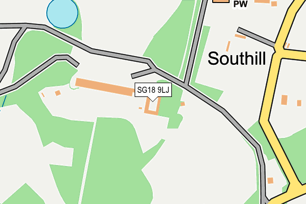
SG18 9LJ is located in the Northill electoral ward, within the unitary authority of Central Bedfordshire and the English Parliamentary constituency of Mid Bedfordshire. The Sub Integrated Care Board (ICB) Location is NHS Bedfordshire, Luton and Milton Keynes ICB - M1J4Y and the police force is Bedfordshire. This postcode has been in use since January 1980.


GetTheData
Source: OS OpenMap – Local (Ordnance Survey)
Source: OS VectorMap District (Ordnance Survey)
Licence: Open Government Licence (requires attribution)
| Easting | 514456 |
| Northing | 242008 |
| Latitude | 52.064642 |
| Longitude | -0.331749 |
GetTheData
Source: Open Postcode Geo
Licence: Open Government Licence
| Country | England |
| Postcode District | SG18 |
| ➜ SG18 open data dashboard ➜ See where SG18 is on a map | |
GetTheData
Source: Land Registry Price Paid Data
Licence: Open Government Licence
Elevation or altitude of SG18 9LJ as distance above sea level:
| Metres | Feet | |
|---|---|---|
| Elevation | 50m | 164ft |
Elevation is measured from the approximate centre of the postcode, to the nearest point on an OS contour line from OS Terrain 50, which has contour spacing of ten vertical metres.
➜ How high above sea level am I? Find the elevation of your current position using your device's GPS.
GetTheData
Source: Open Postcode Elevation
Licence: Open Government Licence
| Ward | Northill |
| Constituency | Mid Bedfordshire |
GetTheData
Source: ONS Postcode Database
Licence: Open Government Licence
| June 2022 | Burglary | On or near School Lane | 431m |
| June 2022 | Burglary | On or near School Lane | 431m |
| May 2022 | Other theft | On or near Sports/Recreation Area | 121m |
| ➜ Get more crime data in our Crime section | |||
GetTheData
Source: data.police.uk
Licence: Open Government Licence
| Stanford Road (High Street) | Southill | 1,102m |
| Stanford Road (High Street) | Southill | 1,118m |
| Memorial (Stanford Road) | Southill | 1,152m |
| Memorial (Stanford Road) | Southill | 1,160m |
| Biggleswade Station | 5.3km |
| Arlesey Station | 6.2km |
GetTheData
Source: NaPTAN
Licence: Open Government Licence
GetTheData
Source: ONS Postcode Database
Licence: Open Government Licence


➜ Get more ratings from the Food Standards Agency
GetTheData
Source: Food Standards Agency
Licence: FSA terms & conditions
| Last Collection | |||
|---|---|---|---|
| Location | Mon-Fri | Sat | Distance |
| School Lane | 16:20 | 09:10 | 562m |
| High Street | 16:25 | 09:10 | 1,111m |
| Ireland | 16:15 | 10:00 | 1,173m |
GetTheData
Source: Dracos
Licence: Creative Commons Attribution-ShareAlike
| Facility | Distance |
|---|---|
| Southill Park Cricket Club Southill Park, Southill Grass Pitches | 137m |
| Southill Parish Hall Stanford Road, Southill Sports Hall | 1.1km |
| Old Warden Cricket Club The Village, Old Warden Grass Pitches | 2.4km |
GetTheData
Source: Active Places
Licence: Open Government Licence
| School | Phase of Education | Distance |
|---|---|---|
| Southill Lower School School Lane, Southill, Biggleswade, SG18 9JA | Primary | 517m |
| Samuel Whitbread Academy Shefford Road, Clifton, Shefford, SG17 5QS | Secondary | 3.2km |
| Shefford Lower School School Lane, Shefford, SG17 5XA | Primary | 3.3km |
GetTheData
Source: Edubase
Licence: Open Government Licence
The below table lists the International Territorial Level (ITL) codes (formerly Nomenclature of Territorial Units for Statistics (NUTS) codes) and Local Administrative Units (LAU) codes for SG18 9LJ:
| ITL 1 Code | Name |
|---|---|
| TLH | East |
| ITL 2 Code | Name |
| TLH2 | Bedfordshire and Hertfordshire |
| ITL 3 Code | Name |
| TLH25 | Central Bedfordshire |
| LAU 1 Code | Name |
| E06000056 | Central Bedfordshire |
GetTheData
Source: ONS Postcode Directory
Licence: Open Government Licence
The below table lists the Census Output Area (OA), Lower Layer Super Output Area (LSOA), and Middle Layer Super Output Area (MSOA) for SG18 9LJ:
| Code | Name | |
|---|---|---|
| OA | E00087932 | |
| LSOA | E01017412 | Central Bedfordshire 004A |
| MSOA | E02003602 | Central Bedfordshire 004 |
GetTheData
Source: ONS Postcode Directory
Licence: Open Government Licence
| SG18 9LH | 261m | |
| SG18 9JA | School Lane | 508m |
| SG18 9HT | Chapel Lane | 1047m |
| SG18 9HX | Stanford Road | 1195m |
| SG17 5QL | 1250m | |
| SG18 9LP | 1498m | |
| SG17 5NS | Stanford Road | 1748m |
| SG18 9EY | Broom Road | 1860m |
| SG18 9JE | Broom Road | 1905m |
| SG18 9HQ | The Village | 1963m |
GetTheData
Source: Open Postcode Geo; Land Registry Price Paid Data
Licence: Open Government Licence