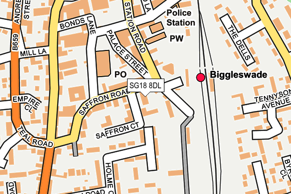
SG18 8DL is located in the Biggleswade West electoral ward, within the unitary authority of Central Bedfordshire and the English Parliamentary constituency of North East Bedfordshire. The Sub Integrated Care Board (ICB) Location is NHS Bedfordshire, Luton and Milton Keynes ICB - M1J4Y and the police force is Bedfordshire. This postcode has been in use since May 2006.


GetTheData
Source: OS OpenMap – Local (Ordnance Survey)
Source: OS VectorMap District (Ordnance Survey)
Licence: Open Government Licence (requires attribution)
| Easting | 519140 |
| Northing | 244331 |
| Latitude | 52.084520 |
| Longitude | -0.262667 |
GetTheData
Source: Open Postcode Geo
Licence: Open Government Licence
| Country | England |
| Postcode District | SG18 |
| ➜ SG18 open data dashboard ➜ See where SG18 is on a map ➜ Where is Biggleswade? | |
GetTheData
Source: Land Registry Price Paid Data
Licence: Open Government Licence
Elevation or altitude of SG18 8DL as distance above sea level:
| Metres | Feet | |
|---|---|---|
| Elevation | 30m | 98ft |
Elevation is measured from the approximate centre of the postcode, to the nearest point on an OS contour line from OS Terrain 50, which has contour spacing of ten vertical metres.
➜ How high above sea level am I? Find the elevation of your current position using your device's GPS.
GetTheData
Source: Open Postcode Elevation
Licence: Open Government Licence
| Ward | Biggleswade West |
| Constituency | North East Bedfordshire |
GetTheData
Source: ONS Postcode Database
Licence: Open Government Licence
| January 2024 | Anti-social behaviour | On or near Parking Area | 115m |
| January 2024 | Violence and sexual offences | On or near Parking Area | 318m |
| January 2024 | Violence and sexual offences | On or near Parking Area | 398m |
| ➜ Get more crime data in our Crime section | |||
GetTheData
Source: data.police.uk
Licence: Open Government Licence
| Station Road | Biggleswade | 66m |
| Blunham Road (Hitchin Street) | Biggleswade | 258m |
| Bus Station (Biggleswade Centre) | Biggleswade | 271m |
| Bus Station (Biggleswade Centre) | Biggleswade | 277m |
| Teal Road | Biggleswade | 277m |
| Biggleswade Station | 0.1km |
| Sandy Station | 4.6km |
GetTheData
Source: NaPTAN
Licence: Open Government Licence
GetTheData
Source: ONS Postcode Database
Licence: Open Government Licence


➜ Get more ratings from the Food Standards Agency
GetTheData
Source: Food Standards Agency
Licence: FSA terms & conditions
| Last Collection | |||
|---|---|---|---|
| Location | Mon-Fri | Sat | Distance |
| Budgens | 18:45 | 11:00 | 128m |
| Biggleswade | 17:45 | 12:00 | 147m |
| Saffron Road | 17:15 | 11:00 | 186m |
GetTheData
Source: Dracos
Licence: Creative Commons Attribution-ShareAlike
| Facility | Distance |
|---|---|
| Keytone Leisure Ltd (Closed) High Street, Biggleswade Health and Fitness Gym | 322m |
| Biggleswade Conservative Tennis Club St. Andrews Street, Biggleswade Outdoor Tennis Courts | 382m |
| Biggleswade Academy Trust (Holmemead Middle School) Mead End, Biggleswade Sports Hall, Grass Pitches | 756m |
GetTheData
Source: Active Places
Licence: Open Government Licence
| School | Phase of Education | Distance |
|---|---|---|
| Lawnside Academy Lawnside, Biggleswade, SG18 0LX | Primary | 615m |
| St Andrew's CofE VC Lower School Brunts Lane, Biggleswade, SG18 0LY | Primary | 663m |
| Biggleswade Academy Mead End, Biggleswade, SG18 8JU | Middle deemed primary | 784m |
GetTheData
Source: Edubase
Licence: Open Government Licence
The below table lists the International Territorial Level (ITL) codes (formerly Nomenclature of Territorial Units for Statistics (NUTS) codes) and Local Administrative Units (LAU) codes for SG18 8DL:
| ITL 1 Code | Name |
|---|---|
| TLH | East |
| ITL 2 Code | Name |
| TLH2 | Bedfordshire and Hertfordshire |
| ITL 3 Code | Name |
| TLH25 | Central Bedfordshire |
| LAU 1 Code | Name |
| E06000056 | Central Bedfordshire |
GetTheData
Source: ONS Postcode Directory
Licence: Open Government Licence
The below table lists the Census Output Area (OA), Lower Layer Super Output Area (LSOA), and Middle Layer Super Output Area (MSOA) for SG18 8DL:
| Code | Name | |
|---|---|---|
| OA | E00087804 | |
| LSOA | E01017385 | Central Bedfordshire 005C |
| MSOA | E02003603 | Central Bedfordshire 005 |
GetTheData
Source: ONS Postcode Directory
Licence: Open Government Licence
| SG18 8DR | Saffron Court | 48m |
| SG18 8AJ | Station Road | 55m |
| SG18 8AL | Station Road | 73m |
| SG18 8DP | Palace Street | 89m |
| SG18 8DA | Holme Crescent | 98m |
| SG18 8DJ | Saffron Road | 135m |
| SG18 8DW | Foundry Lane | 138m |
| SG18 8DB | Holme Crescent | 155m |
| SG18 8AW | Station Road | 160m |
| SG18 8BW | Blunham Road | 196m |
GetTheData
Source: Open Postcode Geo; Land Registry Price Paid Data
Licence: Open Government Licence