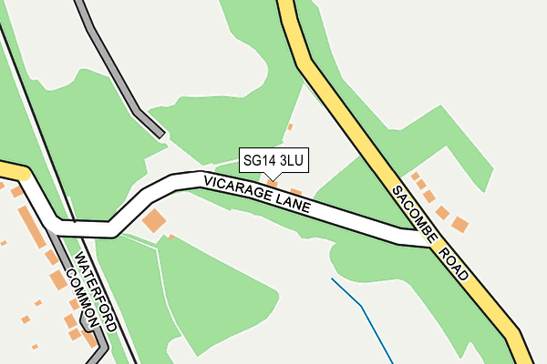
SG14 3LU lies on Vicarage Lane in Waterford, Hertford. SG14 3LU is located in the Hertford Bengeo electoral ward, within the local authority district of East Hertfordshire and the English Parliamentary constituency of Hertford and Stortford. The Sub Integrated Care Board (ICB) Location is NHS Hertfordshire and West Essex ICB - 06K and the police force is Hertfordshire. This postcode has been in use since January 1980.


GetTheData
Source: OS OpenMap – Local (Ordnance Survey)
Source: OS VectorMap District (Ordnance Survey)
Licence: Open Government Licence (requires attribution)
| Easting | 531810 |
| Northing | 214975 |
| Latitude | 51.817872 |
| Longitude | -0.089085 |
GetTheData
Source: Open Postcode Geo
Licence: Open Government Licence
| Street | Vicarage Lane |
| Locality | Waterford |
| Town/City | Hertford |
| Country | England |
| Postcode District | SG14 |
| ➜ SG14 open data dashboard ➜ See where SG14 is on a map | |
GetTheData
Source: Land Registry Price Paid Data
Licence: Open Government Licence
Elevation or altitude of SG14 3LU as distance above sea level:
| Metres | Feet | |
|---|---|---|
| Elevation | 70m | 230ft |
Elevation is measured from the approximate centre of the postcode, to the nearest point on an OS contour line from OS Terrain 50, which has contour spacing of ten vertical metres.
➜ How high above sea level am I? Find the elevation of your current position using your device's GPS.
GetTheData
Source: Open Postcode Elevation
Licence: Open Government Licence
| Ward | Hertford Bengeo |
| Constituency | Hertford And Stortford |
GetTheData
Source: ONS Postcode Database
Licence: Open Government Licence
| June 2022 | Anti-social behaviour | On or near Vicarage Lane | 28m |
| May 2022 | Anti-social behaviour | On or near Barley Croft | 476m |
| August 2021 | Burglary | On or near Vicarage Lane | 28m |
| ➜ Get more crime data in our Crime section | |||
GetTheData
Source: data.police.uk
Licence: Open Government Licence
| St Michaels & All Angels Church (High Road) | Waterford | 584m |
| St Michaels & All Angels Church (High Road) | Waterford | 601m |
| Vicarage Lane (High Road) | Waterford | 676m |
| Vicarage Lane (High Road) | Waterford | 692m |
| Peel Crescent (Cowper Crescent) | Bengeo | 914m |
| Hertford North Station | 2.1km |
| Hertford East Station | 2.4km |
| Ware Station | 4.3km |
GetTheData
Source: NaPTAN
Licence: Open Government Licence
| Percentage of properties with Next Generation Access | 100.0% |
| Percentage of properties with Superfast Broadband | 0.0% |
| Percentage of properties with Ultrafast Broadband | 0.0% |
| Percentage of properties with Full Fibre Broadband | 0.0% |
Superfast Broadband is between 30Mbps and 300Mbps
Ultrafast Broadband is > 300Mbps
| Percentage of properties unable to receive 2Mbps | 0.0% |
| Percentage of properties unable to receive 5Mbps | 0.0% |
| Percentage of properties unable to receive 10Mbps | 0.0% |
| Percentage of properties unable to receive 30Mbps | 100.0% |
GetTheData
Source: Ofcom
Licence: Ofcom Terms of Use (requires attribution)
GetTheData
Source: ONS Postcode Database
Licence: Open Government Licence


➜ Get more ratings from the Food Standards Agency
GetTheData
Source: Food Standards Agency
Licence: FSA terms & conditions
| Last Collection | |||
|---|---|---|---|
| Location | Mon-Fri | Sat | Distance |
| Waterford | 17:00 | 08:45 | 675m |
| The Wick | 17:30 | 12:00 | 789m |
| The Avenue | 17:30 | 12:00 | 1,129m |
GetTheData
Source: Dracos
Licence: Creative Commons Attribution-ShareAlike
| Facility | Distance |
|---|---|
| Crouchfields Wadesmil Road, Chapmore End, Ware Grass Pitches | 1.4km |
| Bengeo Sports Ground New Road, Hertford Grass Pitches | 1.6km |
| St Joseph's Catholic Primary School North Road, Hertford Grass Pitches, Swimming Pool | 1.9km |
GetTheData
Source: Active Places
Licence: Open Government Licence
| School | Phase of Education | Distance |
|---|---|---|
| Bengeo Primary School The Avenue, Bengeo, Hertford, SG14 3DX | Primary | 1.1km |
| Duncombe School 4 Warren Park Road, Bengeo, Hertford, SG14 3JA | Not applicable | 1.8km |
| St Joseph's Catholic Primary School (Hertford) St Joseph's Catholic Primary School, North Road, North Road, Hertford, SG14 2BU | Primary | 1.9km |
GetTheData
Source: Edubase
Licence: Open Government Licence
The below table lists the International Territorial Level (ITL) codes (formerly Nomenclature of Territorial Units for Statistics (NUTS) codes) and Local Administrative Units (LAU) codes for SG14 3LU:
| ITL 1 Code | Name |
|---|---|
| TLH | East |
| ITL 2 Code | Name |
| TLH2 | Bedfordshire and Hertfordshire |
| ITL 3 Code | Name |
| TLH23 | Hertfordshire CC |
| LAU 1 Code | Name |
| E07000242 | East Hertfordshire |
GetTheData
Source: ONS Postcode Directory
Licence: Open Government Licence
The below table lists the Census Output Area (OA), Lower Layer Super Output Area (LSOA), and Middle Layer Super Output Area (MSOA) for SG14 3LU:
| Code | Name | |
|---|---|---|
| OA | E00119216 | |
| LSOA | E01023473 | East Hertfordshire 014D |
| MSOA | E02004891 | East Hertfordshire 014 |
GetTheData
Source: ONS Postcode Directory
Licence: Open Government Licence
| SG14 3LZ | Sacombe Road | 145m |
| SG14 2QD | Waterford Common | 282m |
| SG14 2QA | Vicarage Lane | 482m |
| SG14 2QB | Barleycroft | 491m |
| SG14 2PZ | Vicarage Lane | 610m |
| SG14 2PS | High Road | 613m |
| SG14 3HQ | The Orchard | 617m |
| SG14 2PP | North Road | 645m |
| SG14 2PR | High Road | 651m |
| SG14 3HW | The Wick | 689m |
GetTheData
Source: Open Postcode Geo; Land Registry Price Paid Data
Licence: Open Government Licence