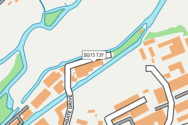
SG13 7JY is located in the Hertford Kingsmead electoral ward, within the local authority district of East Hertfordshire and the English Parliamentary constituency of Hertford and Stortford. The Sub Integrated Care Board (ICB) Location is NHS Hertfordshire and West Essex ICB - 06K and the police force is Hertfordshire. This postcode has been in use since January 1980.


GetTheData
Source: OS OpenMap – Local (Ordnance Survey)
Source: OS VectorMap District (Ordnance Survey)
Licence: Open Government Licence (requires attribution)
| Easting | 533194 |
| Northing | 213343 |
| Latitude | 51.802879 |
| Longitude | -0.069645 |
GetTheData
Source: Open Postcode Geo
Licence: Open Government Licence
| Country | England |
| Postcode District | SG13 |
| ➜ SG13 open data dashboard ➜ See where SG13 is on a map ➜ Where is Hertford? | |
GetTheData
Source: Land Registry Price Paid Data
Licence: Open Government Licence
Elevation or altitude of SG13 7JY as distance above sea level:
| Metres | Feet | |
|---|---|---|
| Elevation | 40m | 131ft |
Elevation is measured from the approximate centre of the postcode, to the nearest point on an OS contour line from OS Terrain 50, which has contour spacing of ten vertical metres.
➜ How high above sea level am I? Find the elevation of your current position using your device's GPS.
GetTheData
Source: Open Postcode Elevation
Licence: Open Government Licence
| Ward | Hertford Kingsmead |
| Constituency | Hertford And Stortford |
GetTheData
Source: ONS Postcode Database
Licence: Open Government Licence
| November 2023 | Anti-social behaviour | On or near Marshgate Drive | 137m |
| November 2023 | Violence and sexual offences | On or near Marshgate Drive | 137m |
| October 2023 | Violence and sexual offences | On or near Marshgate Drive | 137m |
| ➜ Get more crime data in our Crime section | |||
GetTheData
Source: data.police.uk
Licence: Open Government Licence
| Claud Hamilton Way | Hertford | 421m |
| Raynham Street (Ware Road) | Hertford | 531m |
| Caxton Hill (Ware Road) | Hertford | 532m |
| Tesco (Mill Road) | Hertford | 548m |
| Raynham Street (Ware Road) | Hertford | 553m |
| Hertford East Station | 0.5km |
| Hertford North Station | 1.6km |
| Ware Station | 2.9km |
GetTheData
Source: NaPTAN
Licence: Open Government Licence
GetTheData
Source: ONS Postcode Database
Licence: Open Government Licence

➜ Get more ratings from the Food Standards Agency
GetTheData
Source: Food Standards Agency
Licence: FSA terms & conditions
| Last Collection | |||
|---|---|---|---|
| Location | Mon-Fri | Sat | Distance |
| Talbot Street | 17:30 | 12:00 | 414m |
| East Station | 18:30 | 12:15 | 487m |
| New Road | 17:30 | 12:00 | 547m |
GetTheData
Source: Dracos
Licence: Creative Commons Attribution-ShareAlike
| Facility | Distance |
|---|---|
| Hartham Common And Kingsmead Marshgate Drive, Hertford Grass Pitches | 67m |
| Bengeo Sports Ground New Road, Hertford Grass Pitches | 521m |
| Hartham Leisure Centre Hartham Lane, Hertford Swimming Pool, Health and Fitness Gym, Studio, Outdoor Tennis Courts, Artificial Grass Pitch, Grass Pitches | 533m |
GetTheData
Source: Active Places
Licence: Open Government Licence
| School | Phase of Education | Distance |
|---|---|---|
| Duncombe School 4 Warren Park Road, Bengeo, Hertford, SG14 3JA | Not applicable | 814m |
| Abel Smith School Churchfields, Greencoates, Hertford, SG13 8AE | Primary | 883m |
| Wheatcroft Primary School Stanstead Road, Hertford, SG13 7HQ | Primary | 1km |
GetTheData
Source: Edubase
Licence: Open Government Licence
The below table lists the International Territorial Level (ITL) codes (formerly Nomenclature of Territorial Units for Statistics (NUTS) codes) and Local Administrative Units (LAU) codes for SG13 7JY:
| ITL 1 Code | Name |
|---|---|
| TLH | East |
| ITL 2 Code | Name |
| TLH2 | Bedfordshire and Hertfordshire |
| ITL 3 Code | Name |
| TLH23 | Hertfordshire CC |
| LAU 1 Code | Name |
| E07000242 | East Hertfordshire |
GetTheData
Source: ONS Postcode Directory
Licence: Open Government Licence
The below table lists the Census Output Area (OA), Lower Layer Super Output Area (LSOA), and Middle Layer Super Output Area (MSOA) for SG13 7JY:
| Code | Name | |
|---|---|---|
| OA | E00119266 | |
| LSOA | E01023483 | East Hertfordshire 016B |
| MSOA | E02004893 | East Hertfordshire 016 |
GetTheData
Source: ONS Postcode Directory
Licence: Open Government Licence
| SG13 7AU | Smeaton Court | 164m |
| SG13 7BJ | The Mead Business Centre | 201m |
| SG13 7AL | Smeaton Court | 219m |
| SG13 7BD | The Meads | 220m |
| SG13 7AN | Smeaton Court | 223m |
| SG13 7AE | Dicker Mill | 239m |
| SG13 7AQ | Marshgate Drive | 251m |
| SG13 7AH | Spencer Street | 266m |
| SG13 7AX | Mead Lane | 298m |
| SG14 3JR | The Vineyard | 305m |
GetTheData
Source: Open Postcode Geo; Land Registry Price Paid Data
Licence: Open Government Licence