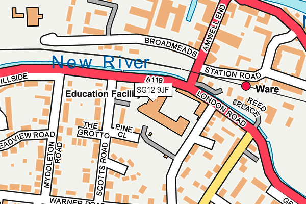
SG12 9JF is located in the Ware Priory electoral ward, within the local authority district of East Hertfordshire and the English Parliamentary constituency of Hertford and Stortford. The Sub Integrated Care Board (ICB) Location is NHS Hertfordshire and West Essex ICB - 06K and the police force is Hertfordshire. This postcode has been in use since January 1980.


GetTheData
Source: OS OpenMap – Local (Ordnance Survey)
Source: OS VectorMap District (Ordnance Survey)
Licence: Open Government Licence (requires attribution)
| Easting | 535808 |
| Northing | 213949 |
| Latitude | 51.807690 |
| Longitude | -0.031549 |
GetTheData
Source: Open Postcode Geo
Licence: Open Government Licence
| Country | England |
| Postcode District | SG12 |
| ➜ SG12 open data dashboard ➜ See where SG12 is on a map ➜ Where is Ware? | |
GetTheData
Source: Land Registry Price Paid Data
Licence: Open Government Licence
Elevation or altitude of SG12 9JF as distance above sea level:
| Metres | Feet | |
|---|---|---|
| Elevation | 40m | 131ft |
Elevation is measured from the approximate centre of the postcode, to the nearest point on an OS contour line from OS Terrain 50, which has contour spacing of ten vertical metres.
➜ How high above sea level am I? Find the elevation of your current position using your device's GPS.
GetTheData
Source: Open Postcode Elevation
Licence: Open Government Licence
| Ward | Ware Priory |
| Constituency | Hertford And Stortford |
GetTheData
Source: ONS Postcode Database
Licence: Open Government Licence
| January 2024 | Violence and sexual offences | On or near Parking Area | 274m |
| December 2023 | Violence and sexual offences | On or near Parking Area | 274m |
| December 2023 | Violence and sexual offences | On or near Burgage Lane | 382m |
| ➜ Get more crime data in our Crime section | |||
GetTheData
Source: data.police.uk
Licence: Open Government Licence
| Hertford Regional College (Hertford Road) | Ware | 42m |
| Hertford Regional College (Hertford Road) | Ware | 55m |
| Hertford Regional College (Amwell End) | Ware | 112m |
| Ware Railway Station (Station Road) | Ware | 257m |
| Ware Railway Station (Station Road) | Ware | 273m |
| Ware Station | 0.2km |
| Hertford East Station | 3km |
| St Margarets (Herts) Station | 3.2km |
GetTheData
Source: NaPTAN
Licence: Open Government Licence
GetTheData
Source: ONS Postcode Database
Licence: Open Government Licence

➜ Get more ratings from the Food Standards Agency
GetTheData
Source: Food Standards Agency
Licence: FSA terms & conditions
| Last Collection | |||
|---|---|---|---|
| Location | Mon-Fri | Sat | Distance |
| Amwell Road | 17:30 | 12:00 | 159m |
| Myddleton Road | 17:15 | 12:00 | 197m |
| Warner Road | 17:15 | 12:00 | 224m |
GetTheData
Source: Dracos
Licence: Creative Commons Attribution-ShareAlike
| Facility | Distance |
|---|---|
| Ware Drill Hall Amwell End, Ware Sports Hall | 198m |
| Sacred Heart Catholic Primary School Broadmeads, Ware Grass Pitches | 287m |
| Christ Church C Of E Primary School New Road, Ware Grass Pitches | 509m |
GetTheData
Source: Active Places
Licence: Open Government Licence
| School | Phase of Education | Distance |
|---|---|---|
| Hertford Regional College Scotts Road, Ware, SG12 9JF | 16 plus | 76m |
| Sacred Heart Catholic Primary School Broadmeads, Ware, SG12 9HY | Primary | 287m |
| Christ Church CofE (VA) Primary School and Nursery New Road, Ware, SG12 7BT | Primary | 509m |
GetTheData
Source: Edubase
Licence: Open Government Licence
The below table lists the International Territorial Level (ITL) codes (formerly Nomenclature of Territorial Units for Statistics (NUTS) codes) and Local Administrative Units (LAU) codes for SG12 9JF:
| ITL 1 Code | Name |
|---|---|
| TLH | East |
| ITL 2 Code | Name |
| TLH2 | Bedfordshire and Hertfordshire |
| ITL 3 Code | Name |
| TLH23 | Hertfordshire CC |
| LAU 1 Code | Name |
| E07000242 | East Hertfordshire |
GetTheData
Source: ONS Postcode Directory
Licence: Open Government Licence
The below table lists the Census Output Area (OA), Lower Layer Super Output Area (LSOA), and Middle Layer Super Output Area (MSOA) for SG12 9JF:
| Code | Name | |
|---|---|---|
| OA | E00119412 | |
| LSOA | E01023510 | East Hertfordshire 013A |
| MSOA | E02004890 | East Hertfordshire 013 |
GetTheData
Source: ONS Postcode Directory
Licence: Open Government Licence
| SG12 9JG | Scotts Road | 111m |
| SG12 9JE | Amwell End | 118m |
| SG12 9JJ | Scotts Close | 129m |
| SG12 9PJ | College Close | 148m |
| SG12 9PQ | Walton Road | 150m |
| SG12 9PH | Walton Road | 167m |
| SG12 9LP | London Road | 169m |
| SG12 9HX | Broadmeads | 173m |
| SG12 9HW | Amwell End | 175m |
| SG12 9JH | The Grotto | 178m |
GetTheData
Source: Open Postcode Geo; Land Registry Price Paid Data
Licence: Open Government Licence