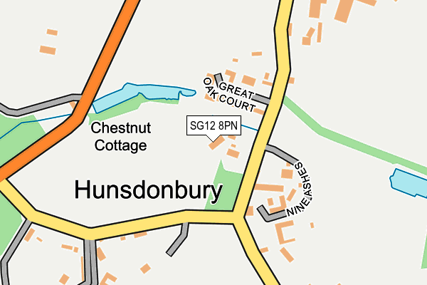
SG12 8PN lies on Acorn Street in Hunsdon, Ware. SG12 8PN is located in the Hunsdon electoral ward, within the local authority district of East Hertfordshire and the English Parliamentary constituency of Hertford and Stortford. The Sub Integrated Care Board (ICB) Location is NHS Hertfordshire and West Essex ICB - 06K and the police force is Hertfordshire. This postcode has been in use since January 1980.


GetTheData
Source: OS OpenMap – Local (Ordnance Survey)
Source: OS VectorMap District (Ordnance Survey)
Licence: Open Government Licence (requires attribution)
| Easting | 541610 |
| Northing | 213315 |
| Latitude | 51.800556 |
| Longitude | 0.052291 |
GetTheData
Source: Open Postcode Geo
Licence: Open Government Licence
| Street | Acorn Street |
| Locality | Hunsdon |
| Town/City | Ware |
| Country | England |
| Postcode District | SG12 |
| ➜ SG12 open data dashboard ➜ See where SG12 is on a map ➜ Where is Hunsdonbury? | |
GetTheData
Source: Land Registry Price Paid Data
Licence: Open Government Licence
Elevation or altitude of SG12 8PN as distance above sea level:
| Metres | Feet | |
|---|---|---|
| Elevation | 70m | 230ft |
Elevation is measured from the approximate centre of the postcode, to the nearest point on an OS contour line from OS Terrain 50, which has contour spacing of ten vertical metres.
➜ How high above sea level am I? Find the elevation of your current position using your device's GPS.
GetTheData
Source: Open Postcode Elevation
Licence: Open Government Licence
| Ward | Hunsdon |
| Constituency | Hertford And Stortford |
GetTheData
Source: ONS Postcode Database
Licence: Open Government Licence
| April 2021 | Criminal damage and arson | On or near Great Oak Court | 79m |
| ➜ Acorn Street crime map and outcomes | |||
GetTheData
Source: data.police.uk
Licence: Open Government Licence
| Memorial (Acorn Street) | Hunsdon | 757m |
| Memorial (Acorn Street) | Hunsdon | 764m |
| The Crown Ph (High Street) | Hunsdon | 804m |
| The Crown Ph (High Street) | Hunsdon | 826m |
| Roydon Station | 3km |
| Harlow Town Station | 3.7km |
| St Margarets (Herts) Station | 3.8km |
GetTheData
Source: NaPTAN
Licence: Open Government Licence
| Percentage of properties with Next Generation Access | 100.0% |
| Percentage of properties with Superfast Broadband | 100.0% |
| Percentage of properties with Ultrafast Broadband | 100.0% |
| Percentage of properties with Full Fibre Broadband | 100.0% |
Superfast Broadband is between 30Mbps and 300Mbps
Ultrafast Broadband is > 300Mbps
| Percentage of properties unable to receive 2Mbps | 0.0% |
| Percentage of properties unable to receive 5Mbps | 0.0% |
| Percentage of properties unable to receive 10Mbps | 0.0% |
| Percentage of properties unable to receive 30Mbps | 0.0% |
GetTheData
Source: Ofcom
Licence: Ofcom Terms of Use (requires attribution)
GetTheData
Source: ONS Postcode Database
Licence: Open Government Licence


➜ Get more ratings from the Food Standards Agency
GetTheData
Source: Food Standards Agency
Licence: FSA terms & conditions
| Last Collection | |||
|---|---|---|---|
| Location | Mon-Fri | Sat | Distance |
| Briggins Park | 16:45 | 07:15 | 1,827m |
| Beningfield Road | 17:00 | 11:00 | 2,574m |
| Roydon Station | 16:45 | 09:00 | 3,034m |
GetTheData
Source: Dracos
Licence: Creative Commons Attribution-ShareAlike
| Facility | Distance |
|---|---|
| Briggens House Hotel And Golf Course (Closed) Stanstead Road, Stanstead Abbotts, Ware Golf | 2.1km |
| Ware Cricket Club Bell Lane, Widford Grass Pitches | 2.3km |
| Widford Playing Field Bell Lane, Widford, Ware Grass Pitches | 2.4km |
GetTheData
Source: Active Places
Licence: Open Government Licence
| School | Phase of Education | Distance |
|---|---|---|
| Hunsdon Junior Mixed and Infant School High Street, Hunsdon, Ware, SG12 8NT | Primary | 908m |
| Widford School Ware Road, Widford, Ware, SG12 8RE | Primary | 2.5km |
| St Andrew's Church of England Voluntary Controlled Primary School Mill Race, Stanstead Abbotts, Ware, SG12 8BZ | Primary | 3.2km |
GetTheData
Source: Edubase
Licence: Open Government Licence
The below table lists the International Territorial Level (ITL) codes (formerly Nomenclature of Territorial Units for Statistics (NUTS) codes) and Local Administrative Units (LAU) codes for SG12 8PN:
| ITL 1 Code | Name |
|---|---|
| TLH | East |
| ITL 2 Code | Name |
| TLH2 | Bedfordshire and Hertfordshire |
| ITL 3 Code | Name |
| TLH23 | Hertfordshire CC |
| LAU 1 Code | Name |
| E07000242 | East Hertfordshire |
GetTheData
Source: ONS Postcode Directory
Licence: Open Government Licence
The below table lists the Census Output Area (OA), Lower Layer Super Output Area (LSOA), and Middle Layer Super Output Area (MSOA) for SG12 8PN:
| Code | Name | |
|---|---|---|
| OA | E00119320 | |
| LSOA | E01023492 | East Hertfordshire 009B |
| MSOA | E02004886 | East Hertfordshire 009 |
GetTheData
Source: ONS Postcode Directory
Licence: Open Government Licence
| SG12 8AN | Great Oak Court | 66m |
| SG12 8PG | Acorn Street | 80m |
| SG12 8PL | Acorn Street | 113m |
| SG12 8PE | Acorn Street | 190m |
| SG12 8PZ | Stanstead Road | 267m |
| SG12 8PW | Hunsdonbury | 269m |
| SG12 8QB | Whitehall Cottages | 321m |
| SG12 8PP | Church Lane | 323m |
| SG12 8QG | Rectory Close | 583m |
| SG12 8QJ | The Homesteads | 629m |
GetTheData
Source: Open Postcode Geo; Land Registry Price Paid Data
Licence: Open Government Licence