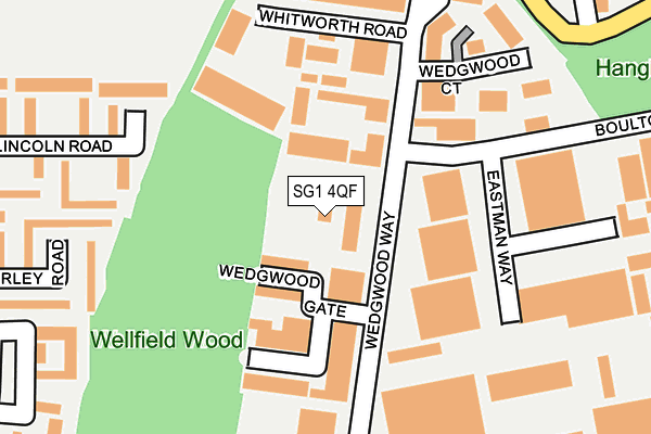
SG1 4QF is located in the St Nicholas electoral ward, within the local authority district of Stevenage and the English Parliamentary constituency of Stevenage. The Sub Integrated Care Board (ICB) Location is NHS Hertfordshire and West Essex ICB - 06K and the police force is Hertfordshire. This postcode has been in use since January 1980.


GetTheData
Source: OS OpenMap – Local (Ordnance Survey)
Source: OS VectorMap District (Ordnance Survey)
Licence: Open Government Licence (requires attribution)
| Easting | 525943 |
| Northing | 226848 |
| Latitude | 51.925920 |
| Longitude | -0.169833 |
GetTheData
Source: Open Postcode Geo
Licence: Open Government Licence
| Country | England |
| Postcode District | SG1 |
| ➜ SG1 open data dashboard ➜ See where SG1 is on a map ➜ Where is Stevenage? | |
GetTheData
Source: Land Registry Price Paid Data
Licence: Open Government Licence
Elevation or altitude of SG1 4QF as distance above sea level:
| Metres | Feet | |
|---|---|---|
| Elevation | 140m | 459ft |
Elevation is measured from the approximate centre of the postcode, to the nearest point on an OS contour line from OS Terrain 50, which has contour spacing of ten vertical metres.
➜ How high above sea level am I? Find the elevation of your current position using your device's GPS.
GetTheData
Source: Open Postcode Elevation
Licence: Open Government Licence
| Ward | St Nicholas |
| Constituency | Stevenage |
GetTheData
Source: ONS Postcode Database
Licence: Open Government Licence
| December 2023 | Anti-social behaviour | On or near Whitehorse Lane | 355m |
| December 2023 | Anti-social behaviour | On or near Whitehorse Lane | 355m |
| December 2023 | Anti-social behaviour | On or near Whitehorse Lane | 355m |
| ➜ Get more crime data in our Crime section | |||
GetTheData
Source: data.police.uk
Licence: Open Government Licence
| Wedgwood Gate (Wedgwood Way) | Martins Wood | 61m |
| Wedgwood Gate (Wedgwood Way) | Martins Wood | 91m |
| Whitworth Road (Wedgwood Way) | Martins Wood | 176m |
| Fairfield Way (Great Ashby Way) | Great Ashby | 272m |
| Cartwright Road | Martins Wood | 292m |
| Stevenage Station | 3.7km |
GetTheData
Source: NaPTAN
Licence: Open Government Licence
Estimated total energy consumption in SG1 4QF by fuel type, 2015.
| Consumption (kWh) | 144,114 |
|---|---|
| Meter count | 7 |
| Mean (kWh/meter) | 20,588 |
| Median (kWh/meter) | 17,923 |
GetTheData
Source: Postcode level gas estimates: 2015 (experimental)
Source: Postcode level electricity estimates: 2015 (experimental)
Licence: Open Government Licence
GetTheData
Source: ONS Postcode Database
Licence: Open Government Licence


➜ Get more ratings from the Food Standards Agency
GetTheData
Source: Food Standards Agency
Licence: FSA terms & conditions
| Last Collection | |||
|---|---|---|---|
| Location | Mon-Fri | Sat | Distance |
| Wedgewood Way | 27m | ||
| Wedgewood Way | 18:45 | 12:00 | 28m |
| Pilgrims Way | 19:00 | 12:00 | 389m |
GetTheData
Source: Dracos
Licence: Creative Commons Attribution-ShareAlike
| Facility | Distance |
|---|---|
| Just For Women (Dominate Fitness Ltd) Wedgewood Gate Industrial Estate, Wedgewood Way, Stevenage Studio, Health and Fitness Gym | 113m |
| Renegade Fitness Academy Whitworth Road, Stevenage Health and Fitness Gym, Studio | 125m |
| Changes Gym (Closed) Wedgewood Gate Industrial Estate, Wedgewood Way, Stevenage Health and Fitness Gym | 143m |
GetTheData
Source: Active Places
Licence: Open Government Licence
| School | Phase of Education | Distance |
|---|---|---|
| Round Diamond Primary School Whitehorse Lane, Great Ashby Way, Stevenage, SG1 6NH | Primary | 459m |
| Martins Wood Primary School Mildmay Road, Stevenage, SG1 5RT | Primary | 717m |
| The Leys Primary and Nursery School Ripon Road, Stevenage, SG1 4QZ | Primary | 719m |
GetTheData
Source: Edubase
Licence: Open Government Licence
The below table lists the International Territorial Level (ITL) codes (formerly Nomenclature of Territorial Units for Statistics (NUTS) codes) and Local Administrative Units (LAU) codes for SG1 4QF:
| ITL 1 Code | Name |
|---|---|
| TLH | East |
| ITL 2 Code | Name |
| TLH2 | Bedfordshire and Hertfordshire |
| ITL 3 Code | Name |
| TLH23 | Hertfordshire CC |
| LAU 1 Code | Name |
| E07000243 | Stevenage |
GetTheData
Source: ONS Postcode Directory
Licence: Open Government Licence
The below table lists the Census Output Area (OA), Lower Layer Super Output Area (LSOA), and Middle Layer Super Output Area (MSOA) for SG1 4QF:
| Code | Name | |
|---|---|---|
| OA | E00120799 | |
| LSOA | E01023789 | Stevenage 001C |
| MSOA | E02004944 | Stevenage 001 |
GetTheData
Source: ONS Postcode Directory
Licence: Open Government Licence
| SG1 4PL | Lincoln Road | 302m |
| SG1 4PP | Beverley Road | 304m |
| SG1 6NJ | Whitehorse Lane | 305m |
| SG1 4PN | Exeter Close | 315m |
| SG1 4PJ | Lincoln Road | 318m |
| SG1 4GP | Admiral Drive | 319m |
| SG1 4PR | Beverley Road | 325m |
| SG1 4GN | Admiral Drive | 326m |
| SG1 4QG | Parsons Green Estate | 326m |
| SG1 6NP | Knott Close | 328m |
GetTheData
Source: Open Postcode Geo; Land Registry Price Paid Data
Licence: Open Government Licence