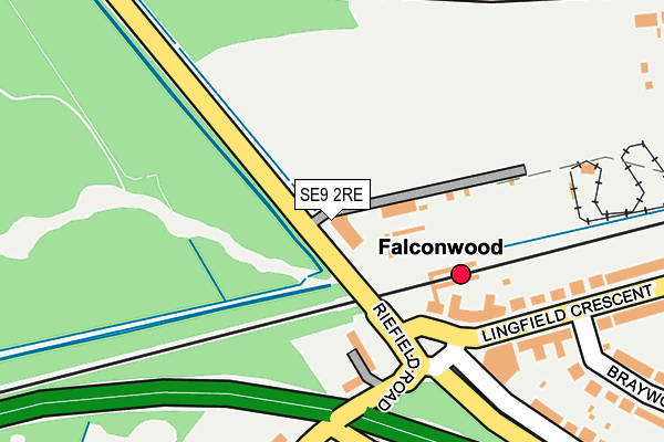
SE9 2RE is located in the Eltham Park & Progress electoral ward, within the London borough of Greenwich and the English Parliamentary constituency of Eltham. The Sub Integrated Care Board (ICB) Location is NHS South East London ICB - 72Q and the police force is Metropolitan Police. This postcode has been in use since January 1980.


GetTheData
Source: OS OpenMap – Local (Ordnance Survey)
Source: OS VectorMap District (Ordnance Survey)
Licence: Open Government Licence (requires attribution)
| Easting | 544480 |
| Northing | 175468 |
| Latitude | 51.459755 |
| Longitude | 0.078281 |
GetTheData
Source: Open Postcode Geo
Licence: Open Government Licence
| Country | England |
| Postcode District | SE9 |
| ➜ SE9 open data dashboard ➜ See where SE9 is on a map ➜ Where is London? | |
GetTheData
Source: Land Registry Price Paid Data
Licence: Open Government Licence
Elevation or altitude of SE9 2RE as distance above sea level:
| Metres | Feet | |
|---|---|---|
| Elevation | 70m | 230ft |
Elevation is measured from the approximate centre of the postcode, to the nearest point on an OS contour line from OS Terrain 50, which has contour spacing of ten vertical metres.
➜ How high above sea level am I? Find the elevation of your current position using your device's GPS.
GetTheData
Source: Open Postcode Elevation
Licence: Open Government Licence
| Ward | Eltham Park & Progress |
| Constituency | Eltham |
GetTheData
Source: ONS Postcode Database
Licence: Open Government Licence
| June 2022 | Violence and sexual offences | On or near Lingfield Crescent | 119m |
| June 2022 | Robbery | On or near A2 | 175m |
| June 2022 | Vehicle crime | On or near Lingfield Crescent | 230m |
| ➜ Get more crime data in our Crime section | |||
GetTheData
Source: data.police.uk
Licence: Open Government Licence
| Rochester Way Falconwood Stn | Avery Hill | 42m |
| Rochester Way Falconwood Stn | Avery Hill | 53m |
| Falconwood (Lingfield Crescent) | Falconwood | 172m |
| Falconwood (Lingfield Crescent) | Falconwood | 176m |
| Eltham Cemetery (Riefield Road) | Avery Hill | 224m |
| Falconwood Station | 0.1km |
| Welling Station | 1.7km |
| Eltham Station | 1.9km |
GetTheData
Source: NaPTAN
Licence: Open Government Licence
GetTheData
Source: ONS Postcode Database
Licence: Open Government Licence


➜ Get more ratings from the Food Standards Agency
GetTheData
Source: Food Standards Agency
Licence: FSA terms & conditions
| Last Collection | |||
|---|---|---|---|
| Location | Mon-Fri | Sat | Distance |
| Lingfield Crescent | 17:30 | 12:00 | 145m |
| Colepits Wood Road | 17:30 | 12:00 | 530m |
| Gipsy Road | 17:30 | 11:00 | 706m |
GetTheData
Source: Dracos
Licence: Creative Commons Attribution-ShareAlike
| Facility | Distance |
|---|---|
| Eastcote Primary School (Closed) Eastcote Road, Welling Grass Pitches | 578m |
| Eastcote Primary School Eastcote Road, Welling Grass Pitches | 578m |
| Crown Woods School (Closed) Riefield Road, London Sports Hall | 625m |
GetTheData
Source: Active Places
Licence: Open Government Licence
| School | Phase of Education | Distance |
|---|---|---|
| Eastcote Primary Academy Eastcote Road, Welling, DA16 2ST | Primary | 578m |
| Bishop Ridley Church of England VA Primary School Northumberland Avenue, Welling, DA16 2QE | Primary | 705m |
| Harris Academy Falconwood The Green, Welling, DA16 2PE | Secondary | 731m |
GetTheData
Source: Edubase
Licence: Open Government Licence
The below table lists the International Territorial Level (ITL) codes (formerly Nomenclature of Territorial Units for Statistics (NUTS) codes) and Local Administrative Units (LAU) codes for SE9 2RE:
| ITL 1 Code | Name |
|---|---|
| TLI | London |
| ITL 2 Code | Name |
| TLI5 | Outer London - East and North East |
| ITL 3 Code | Name |
| TLI51 | Bexley and Greenwich |
| LAU 1 Code | Name |
| E09000011 | Greenwich |
GetTheData
Source: ONS Postcode Directory
Licence: Open Government Licence
The below table lists the Census Output Area (OA), Lower Layer Super Output Area (LSOA), and Middle Layer Super Output Area (MSOA) for SE9 2RE:
| Code | Name | |
|---|---|---|
| OA | E00008005 | |
| LSOA | E01001605 | Greenwich 023A |
| MSOA | E02000335 | Greenwich 023 |
GetTheData
Source: ONS Postcode Directory
Licence: Open Government Licence
| SE9 2RD | Riefield Road | 127m |
| SE9 2RL | Lingfield Crescent | 211m |
| SE9 2RW | Lingfield Crescent | 215m |
| SE9 2RH | Braywood Road | 326m |
| SE9 2RB | Riefield Road | 344m |
| SE9 2RJ | Lingfield Crescent | 347m |
| DA16 2QQ | Millbrook Avenue | 388m |
| SE9 2RG | Wincrofts Drive | 406m |
| DA16 2QU | Montrose Avenue | 447m |
| SE9 2RQ | Lingfield Crescent | 460m |
GetTheData
Source: Open Postcode Geo; Land Registry Price Paid Data
Licence: Open Government Licence