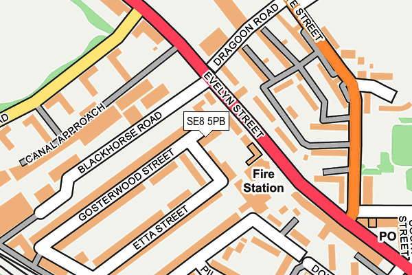
SE8 5PB lies on Gosterwood Street in London. SE8 5PB is located in the Evelyn electoral ward, within the London borough of Lewisham and the English Parliamentary constituency of Lewisham, Deptford. The Sub Integrated Care Board (ICB) Location is NHS South East London ICB - 72Q and the police force is Metropolitan Police. This postcode has been in use since January 1980.


GetTheData
Source: OS OpenMap – Local (Ordnance Survey)
Source: OS VectorMap District (Ordnance Survey)
Licence: Open Government Licence (requires attribution)
| Easting | 536536 |
| Northing | 178059 |
| Latitude | 51.485010 |
| Longitude | -0.034966 |
GetTheData
Source: Open Postcode Geo
Licence: Open Government Licence
| Street | Gosterwood Street |
| Town/City | London |
| Country | England |
| Postcode District | SE8 |
➜ See where SE8 is on a map ➜ Where is Deptford? | |
GetTheData
Source: Land Registry Price Paid Data
Licence: Open Government Licence
Elevation or altitude of SE8 5PB as distance above sea level:
| Metres | Feet | |
|---|---|---|
| Elevation | 10m | 33ft |
Elevation is measured from the approximate centre of the postcode, to the nearest point on an OS contour line from OS Terrain 50, which has contour spacing of ten vertical metres.
➜ How high above sea level am I? Find the elevation of your current position using your device's GPS.
GetTheData
Source: Open Postcode Elevation
Licence: Open Government Licence
| Ward | Evelyn |
| Constituency | Lewisham, Deptford |
GetTheData
Source: ONS Postcode Database
Licence: Open Government Licence
| Deptford Fire Station (Evelyn Street) | Deptford | 65m |
| Deptford Fire Station (Evelyn Street) | Deptford | 94m |
| Evelyn Street Grinstead Rd (Evelyn Street) | Deptford | 239m |
| Abinger Grove (Evelyn Street) | Deptford | 257m |
| Abinger Grove (Evelyn Street) | Deptford | 314m |
| Deptford Bridge Dlr Station (Deptford Bridge) | Deptford Bridge | 1,484m |
| Mudchute Dlr Station (East Ferry Road) | Mudchute | 1,543m |
| Canada Water Underground Station | Canada Water | 1,765m |
| Crossharbour Dlr Station (Limeharbour) | Crossharbour | 1,851m |
| Deptford Station | 0.9km |
| New Cross ELL Station | 1km |
| New Cross Gate ELL Station | 1.2km |
GetTheData
Source: NaPTAN
Licence: Open Government Licence
| Percentage of properties with Next Generation Access | 100.0% |
| Percentage of properties with Superfast Broadband | 100.0% |
| Percentage of properties with Ultrafast Broadband | 81.8% |
| Percentage of properties with Full Fibre Broadband | 0.0% |
Superfast Broadband is between 30Mbps and 300Mbps
Ultrafast Broadband is > 300Mbps
| Median download speed | 24.8Mbps |
| Average download speed | 36.5Mbps |
| Maximum download speed | 100.00Mbps |
| Median upload speed | 5.8Mbps |
| Average upload speed | 6.2Mbps |
| Maximum upload speed | 10.00Mbps |
| Percentage of properties unable to receive 2Mbps | 0.0% |
| Percentage of properties unable to receive 5Mbps | 0.0% |
| Percentage of properties unable to receive 10Mbps | 0.0% |
| Percentage of properties unable to receive 30Mbps | 0.0% |
GetTheData
Source: Ofcom
Licence: Ofcom Terms of Use (requires attribution)
Estimated total energy consumption in SE8 5PB by fuel type, 2015.
| Consumption (kWh) | 67,153 |
|---|---|
| Meter count | 9 |
| Mean (kWh/meter) | 7,461 |
| Median (kWh/meter) | 5,843 |
| Consumption (kWh) | 27,156 |
|---|---|
| Meter count | 10 |
| Mean (kWh/meter) | 2,716 |
| Median (kWh/meter) | 2,490 |
GetTheData
Source: Postcode level gas estimates: 2015 (experimental)
Source: Postcode level electricity estimates: 2015 (experimental)
Licence: Open Government Licence
GetTheData
Source: ONS Postcode Database
Licence: Open Government Licence


➜ Get more ratings from the Food Standards Agency
GetTheData
Source: Food Standards Agency
Licence: FSA terms & conditions
| Last Collection | |||
|---|---|---|---|
| Location | Mon-Fri | Sat | Distance |
| 198 Evelyn Street | 17:30 | 12:00 | 117m |
| Etta Street | 17:30 | 12:00 | 243m |
| Post Office | 17:30 | 12:00 | 272m |
GetTheData
Source: Dracos
Licence: Creative Commons Attribution-ShareAlike
| Risk of SE8 5PB flooding from rivers and sea | Very Low |
| ➜ SE8 5PB flood map | |
GetTheData
Source: Open Flood Risk by Postcode
Licence: Open Government Licence
The below table lists the International Territorial Level (ITL) codes (formerly Nomenclature of Territorial Units for Statistics (NUTS) codes) and Local Administrative Units (LAU) codes for SE8 5PB:
| ITL 1 Code | Name |
|---|---|
| TLI | London |
| ITL 2 Code | Name |
| TLI4 | Inner London - East |
| ITL 3 Code | Name |
| TLI44 | Lewisham and Southwark |
| LAU 1 Code | Name |
| E09000023 | Lewisham |
GetTheData
Source: ONS Postcode Directory
Licence: Open Government Licence
The below table lists the Census Output Area (OA), Lower Layer Super Output Area (LSOA), and Middle Layer Super Output Area (MSOA) for SE8 5PB:
| Code | Name | |
|---|---|---|
| OA | E00016413 | |
| LSOA | E01003248 | Lewisham 002B |
| MSOA | E02000654 | Lewisham 002 |
GetTheData
Source: ONS Postcode Directory
Licence: Open Government Licence
| SE8 5NP | Alverton Street | 40m |
| SE8 5NH | Alverton Street | 47m |
| SE8 5DB | Evelyn Street | 56m |
| SE8 5NX | Gosterwood Street | 64m |
| SE8 5PA | Gosterwood Street | 65m |
| SE8 5NS | Etta Street | 91m |
| SE8 5RD | Grove Street | 106m |
| SE8 5RB | Grove Street | 123m |
| SE8 3LU | Grove Street | 133m |
| SE8 5NL | Rolt Street | 138m |
GetTheData
Source: Open Postcode Geo; Land Registry Price Paid Data
Licence: Open Government Licence