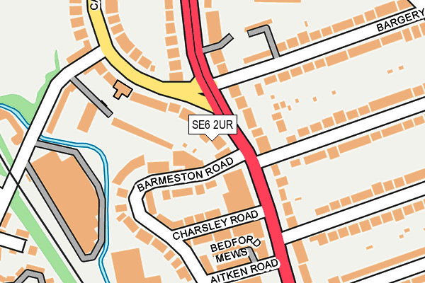
SE6 2UR lies on Bromley Road in London. SE6 2UR is located in the Rushey Green electoral ward, within the London borough of Lewisham and the English Parliamentary constituency of Lewisham East. The Sub Integrated Care Board (ICB) Location is NHS South East London ICB - 72Q and the police force is Metropolitan Police. This postcode has been in use since January 1980.


GetTheData
Source: OS OpenMap – Local (Ordnance Survey)
Source: OS VectorMap District (Ordnance Survey)
Licence: Open Government Licence (requires attribution)
| Easting | 537702 |
| Northing | 172978 |
| Latitude | 51.439068 |
| Longitude | -0.020161 |
GetTheData
Source: Open Postcode Geo
Licence: Open Government Licence
| Street | Bromley Road |
| Town/City | London |
| Country | England |
| Postcode District | SE6 |
➜ See where SE6 is on a map ➜ Where is Catford? | |
GetTheData
Source: Land Registry Price Paid Data
Licence: Open Government Licence
Elevation or altitude of SE6 2UR as distance above sea level:
| Metres | Feet | |
|---|---|---|
| Elevation | 20m | 66ft |
Elevation is measured from the approximate centre of the postcode, to the nearest point on an OS contour line from OS Terrain 50, which has contour spacing of ten vertical metres.
➜ How high above sea level am I? Find the elevation of your current position using your device's GPS.
GetTheData
Source: Open Postcode Elevation
Licence: Open Government Licence
| Ward | Rushey Green |
| Constituency | Lewisham East |
GetTheData
Source: ONS Postcode Database
Licence: Open Government Licence
| Inchmery Road | Bellingham | 41m |
| Inchmery Road (Bromley Road) | Bellingham | 99m |
| Bargery Road | Catford | 168m |
| Fordmill Road | Catford | 225m |
| Canadian Avenue (Fordmill Road) | Catford | 227m |
| Bellingham Station | 0.7km |
| Catford Bridge Station | 0.7km |
| Catford Station | 0.7km |
GetTheData
Source: NaPTAN
Licence: Open Government Licence
| Percentage of properties with Next Generation Access | 100.0% |
| Percentage of properties with Superfast Broadband | 100.0% |
| Percentage of properties with Ultrafast Broadband | 66.7% |
| Percentage of properties with Full Fibre Broadband | 0.0% |
Superfast Broadband is between 30Mbps and 300Mbps
Ultrafast Broadband is > 300Mbps
| Percentage of properties unable to receive 2Mbps | 0.0% |
| Percentage of properties unable to receive 5Mbps | 0.0% |
| Percentage of properties unable to receive 10Mbps | 0.0% |
| Percentage of properties unable to receive 30Mbps | 0.0% |
GetTheData
Source: Ofcom
Licence: Ofcom Terms of Use (requires attribution)
GetTheData
Source: ONS Postcode Database
Licence: Open Government Licence


➜ Get more ratings from the Food Standards Agency
GetTheData
Source: Food Standards Agency
Licence: FSA terms & conditions
| Last Collection | |||
|---|---|---|---|
| Location | Mon-Fri | Sat | Distance |
| Post Office | 17:30 | 12:00 | 41m |
| Bromley Road | 17:30 | 12:00 | 83m |
| Bargery Road | 17:30 | 12:00 | 348m |
GetTheData
Source: Dracos
Licence: Creative Commons Attribution-ShareAlike
| Risk of SE6 2UR flooding from rivers and sea | Low |
| ➜ SE6 2UR flood map | |
GetTheData
Source: Open Flood Risk by Postcode
Licence: Open Government Licence
The below table lists the International Territorial Level (ITL) codes (formerly Nomenclature of Territorial Units for Statistics (NUTS) codes) and Local Administrative Units (LAU) codes for SE6 2UR:
| ITL 1 Code | Name |
|---|---|
| TLI | London |
| ITL 2 Code | Name |
| TLI4 | Inner London - East |
| ITL 3 Code | Name |
| TLI44 | Lewisham and Southwark |
| LAU 1 Code | Name |
| E09000023 | Lewisham |
GetTheData
Source: ONS Postcode Directory
Licence: Open Government Licence
The below table lists the Census Output Area (OA), Lower Layer Super Output Area (LSOA), and Middle Layer Super Output Area (MSOA) for SE6 2UR:
| Code | Name | |
|---|---|---|
| OA | E00016782 | |
| LSOA | E01003318 | Lewisham 020B |
| MSOA | E02000672 | Lewisham 020 |
GetTheData
Source: ONS Postcode Directory
Licence: Open Government Licence
| SE6 2UF | Bromley Road | 74m |
| SE6 3BJ | Barmeston Road | 94m |
| SE6 2NJ | Sambruck Mews | 99m |
| SE6 3AW | Richmond Mews | 118m |
| SE6 2LL | Bargery Road | 126m |
| SE6 2NF | Inchmery Road | 127m |
| SE6 3BP | Canadian Avenue | 130m |
| SE6 2UN | Bromley Road | 132m |
| SE6 3BE | Charsley Road | 139m |
| SE6 3DX | Bedford Mews | 152m |
GetTheData
Source: Open Postcode Geo; Land Registry Price Paid Data
Licence: Open Government Licence