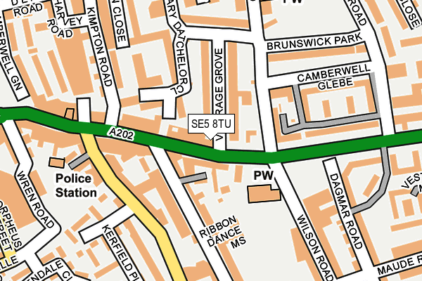
SE5 8TU is located in the St Giles electoral ward, within the London borough of Southwark and the English Parliamentary constituency of Camberwell and Peckham. The Sub Integrated Care Board (ICB) Location is NHS South East London ICB - 72Q and the police force is Metropolitan Police. This postcode has been in use since January 1980.


GetTheData
Source: OS OpenMap – Local (Ordnance Survey)
Source: OS VectorMap District (Ordnance Survey)
Licence: Open Government Licence (requires attribution)
| Easting | 532891 |
| Northing | 176707 |
| Latitude | 51.473727 |
| Longitude | -0.087964 |
GetTheData
Source: Open Postcode Geo
Licence: Open Government Licence
| Country | England |
| Postcode District | SE5 |
| ➜ SE5 open data dashboard ➜ See where SE5 is on a map ➜ Where is Camberwell? | |
GetTheData
Source: Land Registry Price Paid Data
Licence: Open Government Licence
Elevation or altitude of SE5 8TU as distance above sea level:
| Metres | Feet | |
|---|---|---|
| Elevation | 10m | 33ft |
Elevation is measured from the approximate centre of the postcode, to the nearest point on an OS contour line from OS Terrain 50, which has contour spacing of ten vertical metres.
➜ How high above sea level am I? Find the elevation of your current position using your device's GPS.
GetTheData
Source: Open Postcode Elevation
Licence: Open Government Licence
| Ward | St Giles |
| Constituency | Camberwell And Peckham |
GetTheData
Source: ONS Postcode Database
Licence: Open Government Licence
| January 2024 | Anti-social behaviour | On or near Wren Road | 268m |
| January 2024 | Anti-social behaviour | On or near Wren Road | 268m |
| January 2024 | Other theft | On or near Wren Road | 268m |
| ➜ Get more crime data in our Crime section | |||
GetTheData
Source: data.police.uk
Licence: Open Government Licence
| St Giles Church (Camberwell Church Street) | Camberwell | 46m |
| St Giles Church (Peckham Road) | Camberwell | 69m |
| Vestry Road | Camberwell | 236m |
| Camberwell Church St Camberwell Grn (Camberwell Church Street) | Camberwell | 250m |
| Camberwell Church St Camberwell Grn (Camberwell Church Street) | Camberwell | 265m |
| Denmark Hill Station | 0.6km |
| Loughborough Junction Station | 1.3km |
| Peckham Rye Station | 1.4km |
GetTheData
Source: NaPTAN
Licence: Open Government Licence
GetTheData
Source: ONS Postcode Database
Licence: Open Government Licence


➜ Get more ratings from the Food Standards Agency
GetTheData
Source: Food Standards Agency
Licence: FSA terms & conditions
| Last Collection | |||
|---|---|---|---|
| Location | Mon-Fri | Sat | Distance |
| Camberwell Grove | 17:30 | 12:00 | 68m |
| Church Street | 17:30 | 12:00 | 73m |
| Love Walk | 17:30 | 12:00 | 244m |
GetTheData
Source: Dracos
Licence: Creative Commons Attribution-ShareAlike
| Facility | Distance |
|---|---|
| Camberwell Leisure Centre Artichoke Place, London Sports Hall, Swimming Pool, Health and Fitness Gym, Studio | 228m |
| Brunswick Park (Southwark) St. Giles Road, London Outdoor Tennis Courts | 236m |
| Easygym (Camberwell) Denmark Hill, Denmark Hill, London Health and Fitness Gym | 404m |
GetTheData
Source: Active Places
Licence: Open Government Licence
| School | Phase of Education | Distance |
|---|---|---|
| Arco Academy Camberwell Leisure Centre, Artichoke Place, Camberwell, London, SE5 8TS | Not applicable | 228m |
| Lyndhurst Primary School Grove Lane, London, SE5 8SN | Primary | 374m |
| Maudsley and Bethlem Hospital School 1st Floor, Mapother House, Maudsley Hospital, De Crespigny Park, Camberwell, London, SE5 8AZ | Not applicable | 486m |
GetTheData
Source: Edubase
Licence: Open Government Licence
The below table lists the International Territorial Level (ITL) codes (formerly Nomenclature of Territorial Units for Statistics (NUTS) codes) and Local Administrative Units (LAU) codes for SE5 8TU:
| ITL 1 Code | Name |
|---|---|
| TLI | London |
| ITL 2 Code | Name |
| TLI4 | Inner London - East |
| ITL 3 Code | Name |
| TLI44 | Lewisham and Southwark |
| LAU 1 Code | Name |
| E09000028 | Southwark |
GetTheData
Source: ONS Postcode Directory
Licence: Open Government Licence
The below table lists the Census Output Area (OA), Lower Layer Super Output Area (LSOA), and Middle Layer Super Output Area (MSOA) for SE5 8TU:
| Code | Name | |
|---|---|---|
| OA | E00019694 | |
| LSOA | E01003913 | Southwark 024A |
| MSOA | E02000830 | Southwark 024 |
GetTheData
Source: ONS Postcode Directory
Licence: Open Government Licence
| SE5 8QZ | Camberwell Church Street | 59m |
| SE5 7AP | Datchelor Place | 59m |
| SE5 8JD | Chamberlain Cottages | 59m |
| SE5 7LN | Camberwell Church Street | 62m |
| SE5 7LW | Vicarage Grove | 88m |
| SE5 8FB | Camberwell Grove | 90m |
| SE5 7DY | Mary Datchelor Close | 97m |
| SE5 8JA | Camberwell Grove | 97m |
| SE5 7LP | Vicarage Grove | 110m |
| SE5 7NA | Peckham Road | 124m |
GetTheData
Source: Open Postcode Geo; Land Registry Price Paid Data
Licence: Open Government Licence