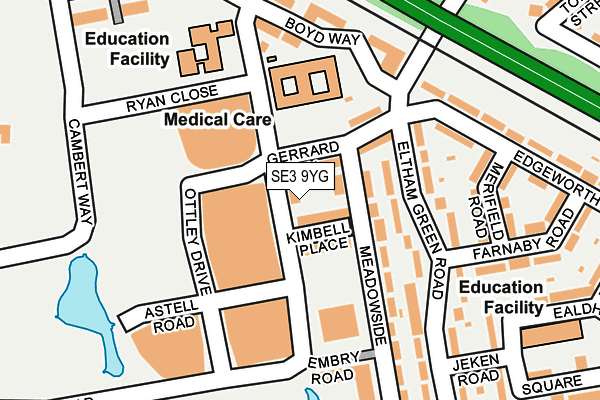
SE3 9YG lies on Tudway Road in London. SE3 9YG is located in the Kidbrooke Village & Sutcliffe electoral ward, within the London borough of Greenwich and the English Parliamentary constituency of Eltham. The Sub Integrated Care Board (ICB) Location is NHS South East London ICB - 72Q and the police force is Metropolitan Police. This postcode has been in use since January 1980.


GetTheData
Source: OS OpenMap – Local (Ordnance Survey)
Source: OS VectorMap District (Ordnance Survey)
Licence: Open Government Licence (requires attribution)
| Easting | 541237 |
| Northing | 175251 |
| Latitude | 51.458624 |
| Longitude | 0.031572 |
GetTheData
Source: Open Postcode Geo
Licence: Open Government Licence
| Street | Tudway Road |
| Town/City | London |
| Country | England |
| Postcode District | SE3 |
➜ See where SE3 is on a map ➜ Where is London? | |
GetTheData
Source: Land Registry Price Paid Data
Licence: Open Government Licence
Elevation or altitude of SE3 9YG as distance above sea level:
| Metres | Feet | |
|---|---|---|
| Elevation | 30m | 98ft |
Elevation is measured from the approximate centre of the postcode, to the nearest point on an OS contour line from OS Terrain 50, which has contour spacing of ten vertical metres.
➜ How high above sea level am I? Find the elevation of your current position using your device's GPS.
GetTheData
Source: Open Postcode Elevation
Licence: Open Government Licence
| Ward | Kidbrooke Village & Sutcliffe |
| Constituency | Eltham |
GetTheData
Source: ONS Postcode Database
Licence: Open Government Licence
| Ryan Close | Kidbrooke | 16m |
| Ryan Close | Kidbrooke | 151m |
| Kidbrooke Station Tudway Road | Kidbrooke | 217m |
| Tudway Road Sutcliffe Park (Tudway Road) | Blackheath Park | 309m |
| Cambert Way (Kidbrooke Park Road) | Blackheath Park | 352m |
| Kidbrooke Station | 0.5km |
| Eltham Station | 1.5km |
| Lee Station | 1.6km |
GetTheData
Source: NaPTAN
Licence: Open Government Licence
| Percentage of properties with Next Generation Access | 75.0% |
| Percentage of properties with Superfast Broadband | 75.0% |
| Percentage of properties with Ultrafast Broadband | 0.0% |
| Percentage of properties with Full Fibre Broadband | 0.0% |
Superfast Broadband is between 30Mbps and 300Mbps
Ultrafast Broadband is > 300Mbps
| Percentage of properties unable to receive 2Mbps | 0.0% |
| Percentage of properties unable to receive 5Mbps | 25.0% |
| Percentage of properties unable to receive 10Mbps | 25.0% |
| Percentage of properties unable to receive 30Mbps | 25.0% |
GetTheData
Source: Ofcom
Licence: Ofcom Terms of Use (requires attribution)
GetTheData
Source: ONS Postcode Database
Licence: Open Government Licence


➜ Get more ratings from the Food Standards Agency
GetTheData
Source: Food Standards Agency
Licence: FSA terms & conditions
| Last Collection | |||
|---|---|---|---|
| Location | Mon-Fri | Sat | Distance |
| Kidbrooke Park Road | 17:30 | 12:00 | 359m |
| Purneys Road | 17:30 | 12:00 | 439m |
| Birdbrook Road | 17:30 | 12:00 | 465m |
GetTheData
Source: Dracos
Licence: Creative Commons Attribution-ShareAlike
| Risk of SE3 9YG flooding from rivers and sea | Low |
| ➜ SE3 9YG flood map | |
GetTheData
Source: Open Flood Risk by Postcode
Licence: Open Government Licence
The below table lists the International Territorial Level (ITL) codes (formerly Nomenclature of Territorial Units for Statistics (NUTS) codes) and Local Administrative Units (LAU) codes for SE3 9YG:
| ITL 1 Code | Name |
|---|---|
| TLI | London |
| ITL 2 Code | Name |
| TLI5 | Outer London - East and North East |
| ITL 3 Code | Name |
| TLI51 | Bexley and Greenwich |
| LAU 1 Code | Name |
| E09000011 | Greenwich |
GetTheData
Source: ONS Postcode Directory
Licence: Open Government Licence
The below table lists the Census Output Area (OA), Lower Layer Super Output Area (LSOA), and Middle Layer Super Output Area (MSOA) for SE3 9YG:
| Code | Name | |
|---|---|---|
| OA | E00176484 | |
| LSOA | E01033726 | Greenwich 034E |
| MSOA | E02006927 | Greenwich 034 |
GetTheData
Source: ONS Postcode Directory
Licence: Open Government Licence
| SE3 9FR | Tudway Road | 51m |
| SE9 6BD | Meadowside | 73m |
| SE3 9FT | Ottley Drive | 94m |
| SE3 9FL | Tudway Road | 121m |
| SE9 6BE | Eltham Green Road | 132m |
| SE3 9FJ | Ottley Drive | 163m |
| SE3 9FB | Astell Road | 176m |
| SE3 9SD | Boyd Way | 183m |
| SE9 6BB | Meadowside | 207m |
| SE9 6BQ | Merifield Road | 208m |
GetTheData
Source: Open Postcode Geo; Land Registry Price Paid Data
Licence: Open Government Licence