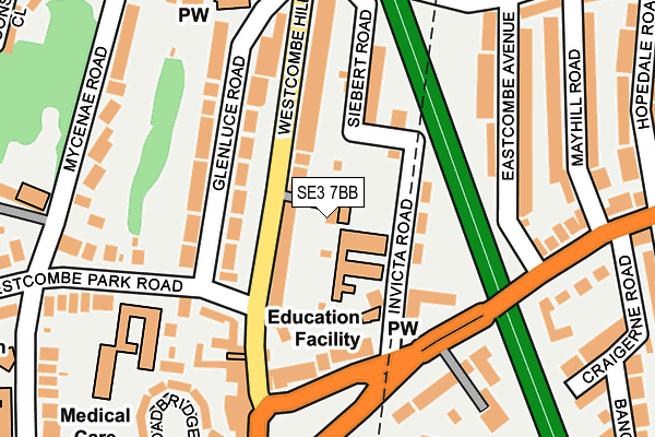
SE3 7BB is located in the Blackheath Westcombe electoral ward, within the London borough of Greenwich and the English Parliamentary constituency of Greenwich and Woolwich. The Sub Integrated Care Board (ICB) Location is NHS South East London ICB - 72Q and the police force is Metropolitan Police. This postcode has been in use since December 2002.


GetTheData
Source: OS OpenMap – Local (Ordnance Survey)
Source: OS VectorMap District (Ordnance Survey)
Licence: Open Government Licence (requires attribution)
| Easting | 540382 |
| Northing | 177537 |
| Latitude | 51.479378 |
| Longitude | 0.020155 |
GetTheData
Source: Open Postcode Geo
Licence: Open Government Licence
| Country | England |
| Postcode District | SE3 |
| ➜ SE3 open data dashboard ➜ See where SE3 is on a map ➜ Where is London? | |
GetTheData
Source: Land Registry Price Paid Data
Licence: Open Government Licence
Elevation or altitude of SE3 7BB as distance above sea level:
| Metres | Feet | |
|---|---|---|
| Elevation | 30m | 98ft |
Elevation is measured from the approximate centre of the postcode, to the nearest point on an OS contour line from OS Terrain 50, which has contour spacing of ten vertical metres.
➜ How high above sea level am I? Find the elevation of your current position using your device's GPS.
GetTheData
Source: Open Postcode Elevation
Licence: Open Government Licence
| Ward | Blackheath Westcombe |
| Constituency | Greenwich And Woolwich |
GetTheData
Source: ONS Postcode Database
Licence: Open Government Licence
| January 2024 | Other theft | On or near Broadbridge Close | 236m |
| January 2024 | Anti-social behaviour | On or near Broadbridge Close | 236m |
| January 2024 | Other theft | On or near Parking Area | 349m |
| ➜ Get more crime data in our Crime section | |||
GetTheData
Source: data.police.uk
Licence: Open Government Licence
| Blackheath Royal Standard | Charlton | 136m |
| Blackheath Royal Standard (Charlton Road) | Charlton | 152m |
| Tudor Grange (Westcombe Park Road) | Charlton | 169m |
| Blackheath Royal Standard (Charlton Road) | Charlton | 186m |
| Kirkside Road (Westcombe Hill) | Charlton | 187m |
| Westcombe Park Station | 0.6km |
| Charlton Station | 1.1km |
| Maze Hill Station | 1.3km |
GetTheData
Source: NaPTAN
Licence: Open Government Licence
GetTheData
Source: ONS Postcode Database
Licence: Open Government Licence


➜ Get more ratings from the Food Standards Agency
GetTheData
Source: Food Standards Agency
Licence: FSA terms & conditions
| Last Collection | |||
|---|---|---|---|
| Location | Mon-Fri | Sat | Distance |
| Post Office | 17:30 | 12:00 | 249m |
| 6 Statheden Parade | 17:30 | 12:00 | 278m |
| 20 Old Dover Road | 17:30 | 12:00 | 308m |
GetTheData
Source: Dracos
Licence: Creative Commons Attribution-ShareAlike
| Facility | Distance |
|---|---|
| Blackheath High School Vanbrugh Park, London Health and Fitness Gym, Studio, Sports Hall | 365m |
| Rectory Fields Lizban Street, London Grass Pitches | 501m |
| The Blackheath Sports Club Charlton Road, Charlton Squash Courts, Outdoor Tennis Courts | 563m |
GetTheData
Source: Active Places
Licence: Open Government Licence
| School | Phase of Education | Distance |
|---|---|---|
| Invicta Primary School Invicta Road, Greenwich, London, SE3 7HE | Primary | 53m |
| Greenwich Steiner School Woodlands, 90 Mycenae Road, Greenwich, London, SE3 7SE | Not applicable | 222m |
| Blackheath High School 27 Vanbrugh Park, Blackheath, SE3 7AG | Not applicable | 365m |
GetTheData
Source: Edubase
Licence: Open Government Licence
The below table lists the International Territorial Level (ITL) codes (formerly Nomenclature of Territorial Units for Statistics (NUTS) codes) and Local Administrative Units (LAU) codes for SE3 7BB:
| ITL 1 Code | Name |
|---|---|
| TLI | London |
| ITL 2 Code | Name |
| TLI5 | Outer London - East and North East |
| ITL 3 Code | Name |
| TLI51 | Bexley and Greenwich |
| LAU 1 Code | Name |
| E09000011 | Greenwich |
GetTheData
Source: ONS Postcode Directory
Licence: Open Government Licence
The below table lists the Census Output Area (OA), Lower Layer Super Output Area (LSOA), and Middle Layer Super Output Area (MSOA) for SE3 7BB:
| Code | Name | |
|---|---|---|
| OA | E00007867 | |
| LSOA | E01001581 | Greenwich 016A |
| MSOA | E02000328 | Greenwich 016 |
GetTheData
Source: ONS Postcode Directory
Licence: Open Government Licence
| SE3 7DR | Westcombe Hill | 46m |
| SE3 7HD | Invicta Road | 86m |
| SE3 7HF | Invicta Road | 88m |
| SE3 7SB | Glenluce Road | 89m |
| SE3 7EJ | Siebert Road | 123m |
| SE3 7SD | Glenluce Road | 134m |
| SE3 7HB | Charlton Road | 141m |
| SE3 7DP | Westcombe Hill | 144m |
| SE3 7EU | Charlton Road | 146m |
| SE3 7DH | Westcombe Hill | 178m |
GetTheData
Source: Open Postcode Geo; Land Registry Price Paid Data
Licence: Open Government Licence