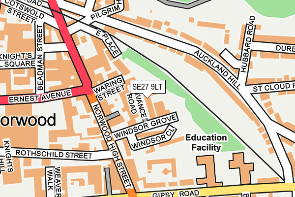
SE27 9LT lies on Advance Road in London. SE27 9LT is located in the Knight's Hill electoral ward, within the London borough of Lambeth and the English Parliamentary constituency of Dulwich and West Norwood. The Sub Integrated Care Board (ICB) Location is NHS South East London ICB - 72Q and the police force is Metropolitan Police. This postcode has been in use since August 1992.


GetTheData
Source: OS OpenMap – Local (Ordnance Survey)
Source: OS VectorMap District (Ordnance Survey)
Licence: Open Government Licence (requires attribution)
| Easting | 532162 |
| Northing | 171776 |
| Latitude | 51.429584 |
| Longitude | -0.100268 |
GetTheData
Source: Open Postcode Geo
Licence: Open Government Licence
| Street | Advance Road |
| Town/City | London |
| Country | England |
| Postcode District | SE27 |
| ➜ SE27 open data dashboard ➜ See where SE27 is on a map ➜ Where is London? | |
GetTheData
Source: Land Registry Price Paid Data
Licence: Open Government Licence
Elevation or altitude of SE27 9LT as distance above sea level:
| Metres | Feet | |
|---|---|---|
| Elevation | 50m | 164ft |
Elevation is measured from the approximate centre of the postcode, to the nearest point on an OS contour line from OS Terrain 50, which has contour spacing of ten vertical metres.
➜ How high above sea level am I? Find the elevation of your current position using your device's GPS.
GetTheData
Source: Open Postcode Elevation
Licence: Open Government Licence
| Ward | Knight's Hill |
| Constituency | Dulwich And West Norwood |
GetTheData
Source: ONS Postcode Database
Licence: Open Government Licence
2, ADVANCE ROAD, LONDON, SE27 9LT 1997 22 MAY £1,275,000 |
GetTheData
Source: HM Land Registry Price Paid Data
Licence: Contains HM Land Registry data © Crown copyright and database right 2024. This data is licensed under the Open Government Licence v3.0.
| January 2024 | Drugs | On or near Benton'S Lane | 337m |
| January 2024 | Drugs | On or near Benton'S Lane | 337m |
| November 2023 | Violence and sexual offences | On or near Benton'S Lane | 337m |
| ➜ Advance Road crime map and outcomes | |||
GetTheData
Source: data.police.uk
Licence: Open Government Licence
| Gipsy Road | West Norwood | 112m |
| Ernest Avenue (Norwood High Street) | West Norwood | 133m |
| Ernest Avenue (Norwood High Street) | West Norwood | 171m |
| West Norwood Bus Garage (Ernest Avenue) | West Norwood | 226m |
| Gipsy Road | West Norwood | 256m |
| West Norwood Station | 0.3km |
| Tulse Hill Station | 1.2km |
| Gipsy Hill Station | 1.3km |
GetTheData
Source: NaPTAN
Licence: Open Government Licence
GetTheData
Source: ONS Postcode Database
Licence: Open Government Licence


➜ Get more ratings from the Food Standards Agency
GetTheData
Source: Food Standards Agency
Licence: FSA terms & conditions
| Last Collection | |||
|---|---|---|---|
| Location | Mon-Fri | Sat | Distance |
| Post Office | 17:30 | 12:00 | 88m |
| Norwood High Street | 17:30 | 12:00 | 108m |
| 159 Auckland Hill | 17:30 | 12:00 | 173m |
GetTheData
Source: Dracos
Licence: Creative Commons Attribution-ShareAlike
| Facility | Distance |
|---|---|
| Park Campus Academy Gipsy Road, London Artificial Grass Pitch, Sports Hall | 217m |
| West Norwood Lawn Tennis Club (Closed) Knights Hill, London Outdoor Tennis Courts | 323m |
| West Norwood Health And Leisure Centre Devane Way, London Health and Fitness Gym, Swimming Pool, Studio | 530m |
GetTheData
Source: Active Places
Licence: Open Government Licence
| School | Phase of Education | Distance |
|---|---|---|
| St Luke's Church of England Primary School Linton Grove, West Norwood, London, SE27 0DZ | Primary | 310m |
| Julian's School 16 Wolfington Road, West Norwood, London, SE27 0JF | Primary | 406m |
| Elm Wood School Carnac Street, West Norwood, London, SE27 9RR | Primary | 638m |
GetTheData
Source: Edubase
Licence: Open Government Licence
The below table lists the International Territorial Level (ITL) codes (formerly Nomenclature of Territorial Units for Statistics (NUTS) codes) and Local Administrative Units (LAU) codes for SE27 9LT:
| ITL 1 Code | Name |
|---|---|
| TLI | London |
| ITL 2 Code | Name |
| TLI4 | Inner London - East |
| ITL 3 Code | Name |
| TLI45 | Lambeth |
| LAU 1 Code | Name |
| E09000022 | Lambeth |
GetTheData
Source: ONS Postcode Directory
Licence: Open Government Licence
The below table lists the Census Output Area (OA), Lower Layer Super Output Area (LSOA), and Middle Layer Super Output Area (MSOA) for SE27 9LT:
| Code | Name | |
|---|---|---|
| OA | E00015440 | |
| LSOA | E01003066 | Lambeth 028B |
| MSOA | E02000645 | Lambeth 028 |
GetTheData
Source: ONS Postcode Directory
Licence: Open Government Licence
| SE27 9JF | Norwood High Street | 46m |
| SE27 9LX | Windsor Close | 72m |
| SE27 9JQ | Dunkirk Street | 74m |
| SE27 9NW | Norwood High Street | 91m |
| SE27 9LU | Windsor Close | 101m |
| SE27 9JW | East Place | 126m |
| SE27 0DQ | Ernest Avenue | 127m |
| SE27 9PD | Auckland Hill | 135m |
| SE27 9JS | Norwood High Street | 138m |
| SE27 9TB | Norwood High Street | 144m |
GetTheData
Source: Open Postcode Geo; Land Registry Price Paid Data
Licence: Open Government Licence