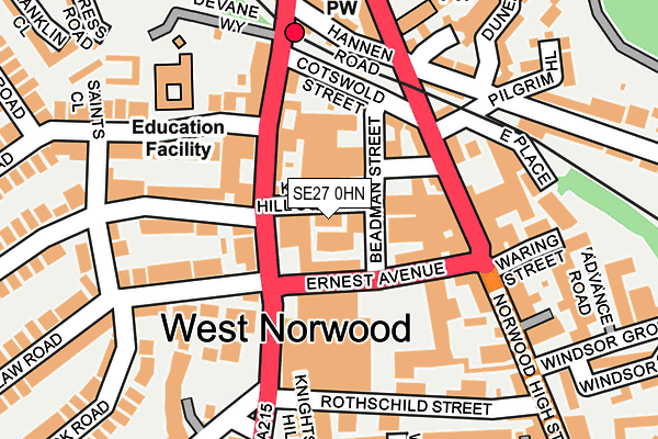
SE27 0HN is located in the Knight's Hill electoral ward, within the London borough of Lambeth and the English Parliamentary constituency of Dulwich and West Norwood. The Sub Integrated Care Board (ICB) Location is NHS South East London ICB - 72Q and the police force is Metropolitan Police. This postcode has been in use since January 1980.


GetTheData
Source: OS OpenMap – Local (Ordnance Survey)
Source: OS VectorMap District (Ordnance Survey)
Licence: Open Government Licence (requires attribution)
| Easting | 531905 |
| Northing | 171825 |
| Latitude | 51.430084 |
| Longitude | -0.103945 |
GetTheData
Source: Open Postcode Geo
Licence: Open Government Licence
| Country | England |
| Postcode District | SE27 |
| ➜ SE27 open data dashboard ➜ See where SE27 is on a map ➜ Where is London? | |
GetTheData
Source: Land Registry Price Paid Data
Licence: Open Government Licence
Elevation or altitude of SE27 0HN as distance above sea level:
| Metres | Feet | |
|---|---|---|
| Elevation | 50m | 164ft |
Elevation is measured from the approximate centre of the postcode, to the nearest point on an OS contour line from OS Terrain 50, which has contour spacing of ten vertical metres.
➜ How high above sea level am I? Find the elevation of your current position using your device's GPS.
GetTheData
Source: Open Postcode Elevation
Licence: Open Government Licence
| Ward | Knight's Hill |
| Constituency | Dulwich And West Norwood |
GetTheData
Source: ONS Postcode Database
Licence: Open Government Licence
| January 2024 | Burglary | On or near Supermarket | 488m |
| January 2024 | Robbery | On or near Supermarket | 488m |
| January 2024 | Shoplifting | On or near Supermarket | 488m |
| ➜ Get more crime data in our Crime section | |||
GetTheData
Source: data.police.uk
Licence: Open Government Licence
| West Norwood Knights Hill | West Norwood | 32m |
| West Norwood Bus Garage (Ernest Avenue) | West Norwood | 69m |
| Ernest Avenue (Norwood High Street) | West Norwood | 94m |
| Rothschild Street | West Norwood | 132m |
| Rothschild Street | West Norwood | 153m |
| West Norwood Station | 0.2km |
| Tulse Hill Station | 1.1km |
| West Dulwich Station | 1.5km |
GetTheData
Source: NaPTAN
Licence: Open Government Licence
GetTheData
Source: ONS Postcode Database
Licence: Open Government Licence


➜ Get more ratings from the Food Standards Agency
GetTheData
Source: Food Standards Agency
Licence: FSA terms & conditions
| Last Collection | |||
|---|---|---|---|
| Location | Mon-Fri | Sat | Distance |
| 11 Knights Hill | 17:30 | 12:00 | 136m |
| Norwood High Street | 17:30 | 12:00 | 156m |
| Thornlaw Road | 17:30 | 12:00 | 181m |
GetTheData
Source: Dracos
Licence: Creative Commons Attribution-ShareAlike
| Facility | Distance |
|---|---|
| West Norwood Lawn Tennis Club (Closed) Knights Hill, London Outdoor Tennis Courts | 113m |
| West Norwood Health And Leisure Centre Devane Way, London Health and Fitness Gym, Swimming Pool, Studio | 329m |
| Park Campus Academy Gipsy Road, London Artificial Grass Pitch, Sports Hall | 463m |
GetTheData
Source: Active Places
Licence: Open Government Licence
| School | Phase of Education | Distance |
|---|---|---|
| Julian's School 16 Wolfington Road, West Norwood, London, SE27 0JF | Primary | 167m |
| St Luke's Church of England Primary School Linton Grove, West Norwood, London, SE27 0DZ | Primary | 461m |
| Crown Lane Primary School Crown Lane, Streatham, London, SW16 3HX | Primary | 808m |
GetTheData
Source: Edubase
Licence: Open Government Licence
The below table lists the International Territorial Level (ITL) codes (formerly Nomenclature of Territorial Units for Statistics (NUTS) codes) and Local Administrative Units (LAU) codes for SE27 0HN:
| ITL 1 Code | Name |
|---|---|
| TLI | London |
| ITL 2 Code | Name |
| TLI4 | Inner London - East |
| ITL 3 Code | Name |
| TLI45 | Lambeth |
| LAU 1 Code | Name |
| E09000022 | Lambeth |
GetTheData
Source: ONS Postcode Directory
Licence: Open Government Licence
The below table lists the Census Output Area (OA), Lower Layer Super Output Area (LSOA), and Middle Layer Super Output Area (MSOA) for SE27 0HN:
| Code | Name | |
|---|---|---|
| OA | E00015564 | |
| LSOA | E01003084 | Lambeth 030B |
| MSOA | E02000647 | Lambeth 030 |
GetTheData
Source: ONS Postcode Directory
Licence: Open Government Licence
| SE27 0JL | Knights Hill | 53m |
| SE27 0HS | Knights Hill | 89m |
| SE27 0DN | Beadman Street | 92m |
| SE27 0JJ | St Julians Farm Road | 117m |
| SE27 0JD | Knights Hill | 126m |
| SE27 9NR | Norwood High Street | 137m |
| SE27 0DW | Cotswold Street | 139m |
| SE27 0JF | Wolfington Road | 141m |
| SE27 0DQ | Ernest Avenue | 141m |
| SE27 9JS | Norwood High Street | 165m |
GetTheData
Source: Open Postcode Geo; Land Registry Price Paid Data
Licence: Open Government Licence