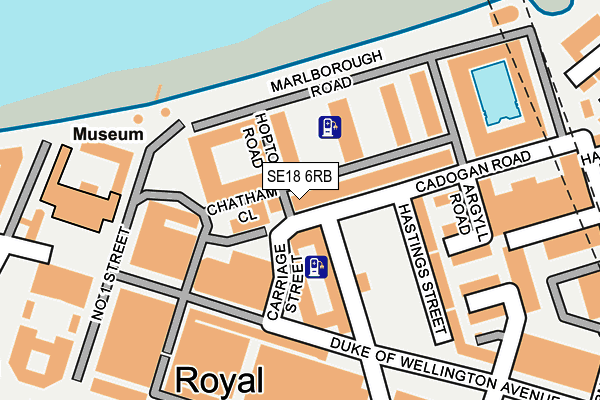
SE18 6RB lies on Cadogan Road in London. SE18 6RB is located in the Woolwich Arsenal electoral ward, within the London borough of Greenwich and the English Parliamentary constituency of Greenwich and Woolwich. The Sub Integrated Care Board (ICB) Location is NHS South East London ICB - 72Q and the police force is Metropolitan Police. This postcode has been in use since August 2004.


GetTheData
Source: OS OpenMap – Local (Ordnance Survey)
Source: OS VectorMap District (Ordnance Survey)
Licence: Open Government Licence (requires attribution)
| Easting | 543978 |
| Northing | 179292 |
| Latitude | 51.494244 |
| Longitude | 0.072617 |
GetTheData
Source: Open Postcode Geo
Licence: Open Government Licence
| Street | Cadogan Road |
| Town/City | London |
| Country | England |
| Postcode District | SE18 |
➜ See where SE18 is on a map ➜ Where is London? | |
GetTheData
Source: Land Registry Price Paid Data
Licence: Open Government Licence
Elevation or altitude of SE18 6RB as distance above sea level:
| Metres | Feet | |
|---|---|---|
| Elevation | 10m | 33ft |
Elevation is measured from the approximate centre of the postcode, to the nearest point on an OS contour line from OS Terrain 50, which has contour spacing of ten vertical metres.
➜ How high above sea level am I? Find the elevation of your current position using your device's GPS.
GetTheData
Source: Open Postcode Elevation
Licence: Open Government Licence
| Ward | Woolwich Arsenal |
| Constituency | Greenwich And Woolwich |
GetTheData
Source: ONS Postcode Database
Licence: Open Government Licence
| Plumstead Road Woolwich Mkt | Woolwich | 334m |
| Plumstead Road Burrage Road (Plumstead Road) | Woolwich | 357m |
| Plumstead Road Woolwich Mkt (Plumstead Road) | Woolwich | 358m |
| Plumstead Road Woolwich Mkt (Plumstead Road) | Woolwich | 359m |
| Beresford Sq Woolwich Arsenal (Beresford Street) | Woolwich | 405m |
| Woolwich Arsenal Dlr Station (Woolwich New Road) | Woolwich | 530m |
| King George V Dlr Station (Rymill Street) | Silvertown | 1,107m |
| Woolwich Arsenal Station | 0.5km |
| Plumstead Station | 0.9km |
| Woolwich Dockyard Station | 1.3km |
GetTheData
Source: NaPTAN
Licence: Open Government Licence
| Percentage of properties with Next Generation Access | 100.0% |
| Percentage of properties with Superfast Broadband | 100.0% |
| Percentage of properties with Ultrafast Broadband | 0.0% |
| Percentage of properties with Full Fibre Broadband | 0.0% |
Superfast Broadband is between 30Mbps and 300Mbps
Ultrafast Broadband is > 300Mbps
| Median download speed | 39.5Mbps |
| Average download speed | 37.8Mbps |
| Maximum download speed | 79.88Mbps |
| Median upload speed | 10.0Mbps |
| Average upload speed | 9.0Mbps |
| Maximum upload speed | 20.00Mbps |
| Percentage of properties unable to receive 2Mbps | 0.0% |
| Percentage of properties unable to receive 5Mbps | 0.0% |
| Percentage of properties unable to receive 10Mbps | 0.0% |
| Percentage of properties unable to receive 30Mbps | 0.0% |
GetTheData
Source: Ofcom
Licence: Ofcom Terms of Use (requires attribution)
Estimated total energy consumption in SE18 6RB by fuel type, 2015.
| Consumption (kWh) | 125,025 |
|---|---|
| Meter count | 12 |
| Mean (kWh/meter) | 10,419 |
| Median (kWh/meter) | 10,194 |
| Consumption (kWh) | 25,857 |
|---|---|
| Meter count | 11 |
| Mean (kWh/meter) | 2,351 |
| Median (kWh/meter) | 1,978 |
GetTheData
Source: Postcode level gas estimates: 2015 (experimental)
Source: Postcode level electricity estimates: 2015 (experimental)
Licence: Open Government Licence
GetTheData
Source: ONS Postcode Database
Licence: Open Government Licence


➜ Get more ratings from the Food Standards Agency
GetTheData
Source: Food Standards Agency
Licence: FSA terms & conditions
| Last Collection | |||
|---|---|---|---|
| Location | Mon-Fri | Sat | Distance |
| Cadogan Road | 17:30 | 12:00 | 102m |
| Arthur Grove | 17:30 | 12:00 | 366m |
| Cornwallis Road | 17:30 | 12:00 | 376m |
GetTheData
Source: Dracos
Licence: Creative Commons Attribution-ShareAlike
| Risk of SE18 6RB flooding from rivers and sea | Very Low |
| ➜ SE18 6RB flood map | |
GetTheData
Source: Open Flood Risk by Postcode
Licence: Open Government Licence
The below table lists the International Territorial Level (ITL) codes (formerly Nomenclature of Territorial Units for Statistics (NUTS) codes) and Local Administrative Units (LAU) codes for SE18 6RB:
| ITL 1 Code | Name |
|---|---|
| TLI | London |
| ITL 2 Code | Name |
| TLI5 | Outer London - East and North East |
| ITL 3 Code | Name |
| TLI51 | Bexley and Greenwich |
| LAU 1 Code | Name |
| E09000011 | Greenwich |
GetTheData
Source: ONS Postcode Directory
Licence: Open Government Licence
The below table lists the Census Output Area (OA), Lower Layer Super Output Area (LSOA), and Middle Layer Super Output Area (MSOA) for SE18 6RB:
| Code | Name | |
|---|---|---|
| OA | E00176583 | |
| LSOA | E01033736 | Greenwich 004H |
| MSOA | E02000316 | Greenwich 004 |
GetTheData
Source: ONS Postcode Directory
Licence: Open Government Licence
| SE18 6TQ | Hopton Road | 31m |
| SE18 6TN | Chatham Close | 47m |
| SE18 6TH | Hopton Road | 51m |
| SE18 6TA | Marlborough Road | 57m |
| SE18 6TG | Hopton Road | 66m |
| SE18 6XD | Marlborough Road | 75m |
| SE18 6RU | Marlborough Road | 83m |
| SE18 6YL | Cadogan Road | 84m |
| SE18 6YN | Cadogan Road | 84m |
| SE18 6YR | Cadogan Road | 84m |
GetTheData
Source: Open Postcode Geo; Land Registry Price Paid Data
Licence: Open Government Licence