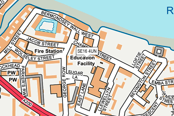
SE16 4UN is located in the North Bermondsey electoral ward, within the London borough of Southwark and the English Parliamentary constituency of Bermondsey and Old Southwark. The Sub Integrated Care Board (ICB) Location is NHS South East London ICB - 72Q and the police force is Metropolitan Police. This postcode has been in use since January 1980.


GetTheData
Source: OS OpenMap – Local (Ordnance Survey)
Source: OS VectorMap District (Ordnance Survey)
Licence: Open Government Licence (requires attribution)
| Easting | 534237 |
| Northing | 179634 |
| Latitude | 51.499713 |
| Longitude | -0.067457 |
GetTheData
Source: Open Postcode Geo
Licence: Open Government Licence
| Country | England |
| Postcode District | SE16 |
➜ See where SE16 is on a map ➜ Where is Bermondsey? | |
GetTheData
Source: Land Registry Price Paid Data
Licence: Open Government Licence
Elevation or altitude of SE16 4UN as distance above sea level:
| Metres | Feet | |
|---|---|---|
| Elevation | 10m | 33ft |
Elevation is measured from the approximate centre of the postcode, to the nearest point on an OS contour line from OS Terrain 50, which has contour spacing of ten vertical metres.
➜ How high above sea level am I? Find the elevation of your current position using your device's GPS.
GetTheData
Source: Open Postcode Elevation
Licence: Open Government Licence
| Ward | North Bermondsey |
| Constituency | Bermondsey And Old Southwark |
GetTheData
Source: ONS Postcode Database
Licence: Open Government Licence
| Jamaica Road Abbey Street (Jamaica Road) | Bermondsey | 180m |
| St James's Road Jamaica Road (Jamaica Road) | Bermondsey | 199m |
| Bermondsey | Bermondsey | 226m |
| Jamaica Road Abbey Street (Jamaica Road) | Bermondsey | 246m |
| Bermondsey (Jamaica Road) | Bermondsey | 264m |
| Bermondsey Underground Station | Bermondsey | 324m |
| Canada Water Underground Station | Canada Water | 1,249m |
| Tower Hill Underground Station | Tower Hill | 1,303m |
| Tower Gateway Dlr Station (Minories) | Tower Gateway | 1,315m |
| Shadwell Dlr Station (Martha Street) | Shadwell | 1,530m |
| Wapping Station | 1km |
| Rotherhithe Station | 1.1km |
| Canada Water Station | 1.2km |
GetTheData
Source: NaPTAN
Licence: Open Government Licence
GetTheData
Source: ONS Postcode Database
Licence: Open Government Licence


➜ Get more ratings from the Food Standards Agency
GetTheData
Source: Food Standards Agency
Licence: FSA terms & conditions
| Last Collection | |||
|---|---|---|---|
| Location | Mon-Fri | Sat | Distance |
| Bevington Street | 17:30 | 12:00 | 173m |
| Old Jamaica Road | 17:30 | 12:00 | 276m |
| 35 Dockhead | 18:30 | 13:00 | 325m |
GetTheData
Source: Dracos
Licence: Creative Commons Attribution-ShareAlike
| Risk of SE16 4UN flooding from rivers and sea | Very Low |
| ➜ SE16 4UN flood map | |
GetTheData
Source: Open Flood Risk by Postcode
Licence: Open Government Licence
The below table lists the International Territorial Level (ITL) codes (formerly Nomenclature of Territorial Units for Statistics (NUTS) codes) and Local Administrative Units (LAU) codes for SE16 4UN:
| ITL 1 Code | Name |
|---|---|
| TLI | London |
| ITL 2 Code | Name |
| TLI4 | Inner London - East |
| ITL 3 Code | Name |
| TLI44 | Lewisham and Southwark |
| LAU 1 Code | Name |
| E09000028 | Southwark |
GetTheData
Source: ONS Postcode Directory
Licence: Open Government Licence
The below table lists the Census Output Area (OA), Lower Layer Super Output Area (LSOA), and Middle Layer Super Output Area (MSOA) for SE16 4UN:
| Code | Name | |
|---|---|---|
| OA | E00020284 | |
| LSOA | E01004022 | Southwark 004C |
| MSOA | E02000810 | Southwark 004 |
GetTheData
Source: ONS Postcode Directory
Licence: Open Government Licence
| SE16 4UR | George Row | 51m |
| SE16 4UZ | East Lane | 65m |
| SE16 4UY | Scott Lidgett Crescent | 72m |
| SE16 4XA | Llewellyn Street | 76m |
| SE16 4XB | Llewellyn Street | 76m |
| SE16 4UT | George Row | 85m |
| SE16 4UU | George Row | 89m |
| SE16 4XL | Chambers Street | 99m |
| SE16 4WG | Chambers Street | 107m |
| SE16 4XD | Llewellyn Street | 109m |
GetTheData
Source: Open Postcode Geo; Land Registry Price Paid Data
Licence: Open Government Licence