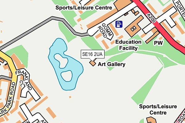
SE16 2UA is located in the Rotherhithe electoral ward, within the London borough of Southwark and the English Parliamentary constituency of Bermondsey and Old Southwark. The Sub Integrated Care Board (ICB) Location is NHS South East London ICB - 72Q and the police force is Metropolitan Police. This postcode has been in use since June 2001.


GetTheData
Source: OS OpenMap – Local (Ordnance Survey)
Source: OS VectorMap District (Ordnance Survey)
Licence: Open Government Licence (requires attribution)
| Easting | 535194 |
| Northing | 179040 |
| Latitude | 51.494147 |
| Longitude | -0.053932 |
GetTheData
Source: Open Postcode Geo
Licence: Open Government Licence
| Country | England |
| Postcode District | SE16 |
➜ See where SE16 is on a map ➜ Where is London? | |
GetTheData
Source: Land Registry Price Paid Data
Licence: Open Government Licence
Elevation or altitude of SE16 2UA as distance above sea level:
| Metres | Feet | |
|---|---|---|
| Elevation | 0m | 0ft |
Elevation is measured from the approximate centre of the postcode, to the nearest point on an OS contour line from OS Terrain 50, which has contour spacing of ten vertical metres.
➜ How high above sea level am I? Find the elevation of your current position using your device's GPS.
GetTheData
Source: Open Postcode Elevation
Licence: Open Government Licence
| Ward | Rotherhithe |
| Constituency | Bermondsey And Old Southwark |
GetTheData
Source: ONS Postcode Database
Licence: Open Government Licence
| Rotherhithe Police Station (Lower Road) | Canada Water | 211m |
| Rotherhithe Police Station (Lower Road) | Canada Water | 260m |
| Surrey Quays Road (Lower Road) | Canada Water | 331m |
| The Stanley Arms (Southwark Park Road) | Bermondsey | 341m |
| Raymouth Road (Southwark Park Road) | Bermondsey | 352m |
| Canada Water Underground Station | Canada Water | 514m |
| Bermondsey Underground Station | Bermondsey | 804m |
| Surrey Quays Station | 0.5km |
| Canada Water Station | 0.5km |
| South Bermondsey Station | 0.7km |
GetTheData
Source: NaPTAN
Licence: Open Government Licence
GetTheData
Source: ONS Postcode Database
Licence: Open Government Licence


➜ Get more ratings from the Food Standards Agency
GetTheData
Source: Food Standards Agency
Licence: FSA terms & conditions
| Last Collection | |||
|---|---|---|---|
| Location | Mon-Fri | Sat | Distance |
| Lower Road | 17:30 | 12:00 | 257m |
| Lower Road | 17:30 | 12:00 | 366m |
| 201 Rotherhithe New Road | 17:30 | 12:00 | 398m |
GetTheData
Source: Dracos
Licence: Creative Commons Attribution-ShareAlike
| Risk of SE16 2UA flooding from rivers and sea | Very Low |
| ➜ SE16 2UA flood map | |
GetTheData
Source: Open Flood Risk by Postcode
Licence: Open Government Licence
The below table lists the International Territorial Level (ITL) codes (formerly Nomenclature of Territorial Units for Statistics (NUTS) codes) and Local Administrative Units (LAU) codes for SE16 2UA:
| ITL 1 Code | Name |
|---|---|
| TLI | London |
| ITL 2 Code | Name |
| TLI4 | Inner London - East |
| ITL 3 Code | Name |
| TLI44 | Lewisham and Southwark |
| LAU 1 Code | Name |
| E09000028 | Southwark |
GetTheData
Source: ONS Postcode Directory
Licence: Open Government Licence
The below table lists the Census Output Area (OA), Lower Layer Super Output Area (LSOA), and Middle Layer Super Output Area (MSOA) for SE16 2UA:
| Code | Name | |
|---|---|---|
| OA | E00020295 | |
| LSOA | E01004031 | Southwark 007B |
| MSOA | E02000813 | Southwark 007 |
GetTheData
Source: ONS Postcode Directory
Licence: Open Government Licence
| SE16 2TY | Gomm Road | 106m |
| SE16 2TX | Gomm Road | 139m |
| SE16 2DP | Abbeyfield Estate | 212m |
| SE16 2DW | Abbeyfield Estate | 212m |
| SE16 2TJ | Ann Moss Way | 223m |
| SE16 2UH | Orange Place | 223m |
| SE16 2UB | Lower Road | 230m |
| SE16 2EZ | Abbeyfield Estate | 232m |
| SE16 2ET | Southwark Park Road | 246m |
| SE16 2XH | Lower Road | 258m |
GetTheData
Source: Open Postcode Geo; Land Registry Price Paid Data
Licence: Open Government Licence