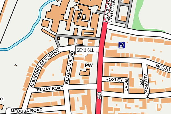
SE13 6LL is located in the Rushey Green electoral ward, within the London borough of Lewisham and the English Parliamentary constituency of Lewisham East. The Sub Integrated Care Board (ICB) Location is NHS South East London ICB - 72Q and the police force is Metropolitan Police. This postcode has been in use since January 1980.


GetTheData
Source: OS OpenMap – Local (Ordnance Survey)
Source: OS VectorMap District (Ordnance Survey)
Licence: Open Government Licence (requires attribution)
| Easting | 537845 |
| Northing | 174386 |
| Latitude | 51.451686 |
| Longitude | -0.017583 |
GetTheData
Source: Open Postcode Geo
Licence: Open Government Licence
| Country | England |
| Postcode District | SE13 |
| ➜ SE13 open data dashboard ➜ See where SE13 is on a map ➜ Where is Lewisham? | |
GetTheData
Source: Land Registry Price Paid Data
Licence: Open Government Licence
Elevation or altitude of SE13 6LL as distance above sea level:
| Metres | Feet | |
|---|---|---|
| Elevation | 20m | 66ft |
Elevation is measured from the approximate centre of the postcode, to the nearest point on an OS contour line from OS Terrain 50, which has contour spacing of ten vertical metres.
➜ How high above sea level am I? Find the elevation of your current position using your device's GPS.
GetTheData
Source: Open Postcode Elevation
Licence: Open Government Licence
| Ward | Rushey Green |
| Constituency | Lewisham East |
GetTheData
Source: ONS Postcode Database
Licence: Open Government Licence
| January 2024 | Anti-social behaviour | On or near Davenport Road | 417m |
| January 2024 | Other theft | On or near Guyscliff Road | 425m |
| January 2024 | Public order | On or near Guyscliff Road | 425m |
| ➜ Get more crime data in our Crime section | |||
GetTheData
Source: data.police.uk
Licence: Open Government Licence
| George Lane (Se13) (Lewisham High Street) | Ladywell | 45m |
| George Lane (Se13) (Lewisham High Street) | Ladywell | 106m |
| Lewisham Hospital (Lewisham High Street) | Ladywell | 148m |
| Lewisham Hospital (Lewisham High Street) | Ladywell | 161m |
| Rosenthal Road (Rushey Green) | Catford | 272m |
| Lewisham Dlr Station (Loampit Vale) | Lewisham | 1,480m |
| Ladywell Station | 0.5km |
| Catford Bridge Station | 0.9km |
| Catford Station | 1km |
GetTheData
Source: NaPTAN
Licence: Open Government Licence
GetTheData
Source: ONS Postcode Database
Licence: Open Government Licence


➜ Get more ratings from the Food Standards Agency
GetTheData
Source: Food Standards Agency
Licence: FSA terms & conditions
| Last Collection | |||
|---|---|---|---|
| Location | Mon-Fri | Sat | Distance |
| Mount Pleasant Road | 17:30 | 12:00 | 72m |
| Lewisham High Street | 17:30 | 12:00 | 96m |
| 20 Rushey Green | 17:30 | 12:00 | 191m |
GetTheData
Source: Dracos
Licence: Creative Commons Attribution-ShareAlike
| Facility | Distance |
|---|---|
| Energie Fitness (Catford) (Closed) Rushey Green, London Health and Fitness Gym | 273m |
| Ladywell Fields Tennis Courts Malyons Road, Ladywell, London Outdoor Tennis Courts | 290m |
| Ladywell Arena Silvermere Road, London Athletics, Health and Fitness Gym, Grass Pitches | 352m |
GetTheData
Source: Active Places
Licence: Open Government Licence
| School | Phase of Education | Distance |
|---|---|---|
| Education-My Life Matters 108 Conisborough Crescent, Bellingham, Catford, London, SE6 2SP | Not applicable | 348m |
| The Family Learning School Capital House, RUSHEY GREEN, CATFORD, LEWISHAM, SE6 4AS | Not applicable | 364m |
| St Mary's Lewisham Church of England Primary School 329 Lewisham High Street, London, SE13 6NX | Primary | 409m |
GetTheData
Source: Edubase
Licence: Open Government Licence
The below table lists the International Territorial Level (ITL) codes (formerly Nomenclature of Territorial Units for Statistics (NUTS) codes) and Local Administrative Units (LAU) codes for SE13 6LL:
| ITL 1 Code | Name |
|---|---|
| TLI | London |
| ITL 2 Code | Name |
| TLI4 | Inner London - East |
| ITL 3 Code | Name |
| TLI44 | Lewisham and Southwark |
| LAU 1 Code | Name |
| E09000023 | Lewisham |
GetTheData
Source: ONS Postcode Directory
Licence: Open Government Licence
The below table lists the Census Output Area (OA), Lower Layer Super Output Area (LSOA), and Middle Layer Super Output Area (MSOA) for SE13 6LL:
| Code | Name | |
|---|---|---|
| OA | E00016811 | |
| LSOA | E01003322 | Lewisham 020D |
| MSOA | E02000672 | Lewisham 020 |
GetTheData
Source: ONS Postcode Directory
Licence: Open Government Licence
| SE13 6LJ | Lewisham High Street | 0m |
| SE13 7HL | Blagdon Road | 44m |
| SE13 6NZ | Lewisham High Street | 96m |
| SE13 7HW | Albacore Crescent | 114m |
| SE13 6RA | Lewisham Park | 114m |
| SE13 7HJ | Felday Road | 140m |
| SE13 6RB | Mount Pleasant Road | 159m |
| SE13 6HG | Roxley Road | 163m |
| SE13 7HQ | Felday Road | 164m |
| SE13 7HH | Blagdon Road | 172m |
GetTheData
Source: Open Postcode Geo; Land Registry Price Paid Data
Licence: Open Government Licence