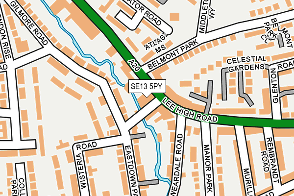
SE13 5PY lies on Lee High Road in London. SE13 5PY is located in the Blackheath electoral ward, within the London borough of Lewisham and the English Parliamentary constituency of Lewisham, Deptford. The Sub Integrated Care Board (ICB) Location is NHS South East London ICB - 72Q and the police force is Metropolitan Police. This postcode has been in use since April 1986.


GetTheData
Source: OS OpenMap – Local (Ordnance Survey)
Source: OS VectorMap District (Ordnance Survey)
Licence: Open Government Licence (requires attribution)
| Easting | 538793 |
| Northing | 175236 |
| Latitude | 51.459092 |
| Longitude | -0.003615 |
GetTheData
Source: Open Postcode Geo
Licence: Open Government Licence
| Street | Lee High Road |
| Town/City | London |
| Country | England |
| Postcode District | SE13 |
➜ See where SE13 is on a map ➜ Where is Lewisham? | |
GetTheData
Source: Land Registry Price Paid Data
Licence: Open Government Licence
Elevation or altitude of SE13 5PY as distance above sea level:
| Metres | Feet | |
|---|---|---|
| Elevation | 10m | 33ft |
Elevation is measured from the approximate centre of the postcode, to the nearest point on an OS contour line from OS Terrain 50, which has contour spacing of ten vertical metres.
➜ How high above sea level am I? Find the elevation of your current position using your device's GPS.
GetTheData
Source: Open Postcode Elevation
Licence: Open Government Licence
| Ward | Blackheath |
| Constituency | Lewisham, Deptford |
GetTheData
Source: ONS Postcode Database
Licence: Open Government Licence
| Belmont Park (Lee High Road) | Lewisham | 18m |
| Manor Road Lee High Road | Lewisham | 136m |
| Manor Park (Lee High Road) | Lee | 150m |
| Belmont Park (Lee High Road) | Lewisham | 150m |
| Manor Road Lee High Road | Lewisham | 159m |
| Lewisham Dlr Station (Loampit Vale) | Lewisham | 893m |
| Elverson Road Dlr Station (Elverson Road) | Elverson Road | 1,436m |
| Hither Green Station | 0.8km |
| Lewisham Station | 1km |
| Ladywell Station | 1.1km |
GetTheData
Source: NaPTAN
Licence: Open Government Licence
GetTheData
Source: ONS Postcode Database
Licence: Open Government Licence


➜ Get more ratings from the Food Standards Agency
GetTheData
Source: Food Standards Agency
Licence: FSA terms & conditions
| Last Collection | |||
|---|---|---|---|
| Location | Mon-Fri | Sat | Distance |
| Post Office | 17:30 | 12:00 | 84m |
| 91 Lee High Road | 17:30 | 12:00 | 255m |
| Rembrandt Road | 17:30 | 12:00 | 258m |
GetTheData
Source: Dracos
Licence: Creative Commons Attribution-ShareAlike
| Risk of SE13 5PY flooding from rivers and sea | Very Low |
| ➜ SE13 5PY flood map | |
GetTheData
Source: Open Flood Risk by Postcode
Licence: Open Government Licence
The below table lists the International Territorial Level (ITL) codes (formerly Nomenclature of Territorial Units for Statistics (NUTS) codes) and Local Administrative Units (LAU) codes for SE13 5PY:
| ITL 1 Code | Name |
|---|---|
| TLI | London |
| ITL 2 Code | Name |
| TLI4 | Inner London - East |
| ITL 3 Code | Name |
| TLI44 | Lewisham and Southwark |
| LAU 1 Code | Name |
| E09000023 | Lewisham |
GetTheData
Source: ONS Postcode Directory
Licence: Open Government Licence
The below table lists the Census Output Area (OA), Lower Layer Super Output Area (LSOA), and Middle Layer Super Output Area (MSOA) for SE13 5PY:
| Code | Name | |
|---|---|---|
| OA | E00016642 | |
| LSOA | E01003288 | Lewisham 012A |
| MSOA | E02000664 | Lewisham 012 |
GetTheData
Source: ONS Postcode Directory
Licence: Open Government Licence
| SE13 5PR | Lee High Road | 42m |
| SE13 5HT | Eastdown Park | 60m |
| SE13 5PB | Manor Park Parade | 70m |
| SE13 5PZ | Waterside Court | 71m |
| SE13 5AB | Gilmore Road | 94m |
| SE13 5PA | Halley Gardens | 110m |
| SE13 5AE | Gilmore Road | 117m |
| SE13 5NZ | Freshfield Close | 117m |
| SE13 5PD | Lee High Road | 123m |
| SE13 5BJ | Belmont Park | 128m |
GetTheData
Source: Open Postcode Geo; Land Registry Price Paid Data
Licence: Open Government Licence