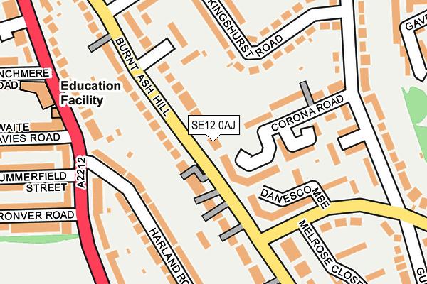
SE12 0AJ is located in the Grove Park electoral ward, within the London borough of Lewisham and the English Parliamentary constituency of Lewisham East. The Sub Integrated Care Board (ICB) Location is NHS South East London ICB - 72Q and the police force is Metropolitan Police. This postcode has been in use since January 1980.


GetTheData
Source: OS OpenMap – Local (Ordnance Survey)
Source: OS VectorMap District (Ordnance Survey)
Licence: Open Government Licence (requires attribution)
| Easting | 540324 |
| Northing | 173564 |
| Latitude | 51.443691 |
| Longitude | 0.017745 |
GetTheData
Source: Open Postcode Geo
Licence: Open Government Licence
| Country | England |
| Postcode District | SE12 |
| ➜ SE12 open data dashboard ➜ See where SE12 is on a map ➜ Where is London? | |
GetTheData
Source: Land Registry Price Paid Data
Licence: Open Government Licence
Elevation or altitude of SE12 0AJ as distance above sea level:
| Metres | Feet | |
|---|---|---|
| Elevation | 50m | 164ft |
Elevation is measured from the approximate centre of the postcode, to the nearest point on an OS contour line from OS Terrain 50, which has contour spacing of ten vertical metres.
➜ How high above sea level am I? Find the elevation of your current position using your device's GPS.
GetTheData
Source: Open Postcode Elevation
Licence: Open Government Licence
| Ward | Grove Park |
| Constituency | Lewisham East |
GetTheData
Source: ONS Postcode Database
Licence: Open Government Licence
| January 2024 | Violence and sexual offences | On or near Elwyn Gardens | 115m |
| January 2024 | Violence and sexual offences | On or near Ratcliffe Close | 147m |
| January 2024 | Vehicle crime | On or near Ratcliffe Close | 147m |
| ➜ Get more crime data in our Crime section | |||
GetTheData
Source: data.police.uk
Licence: Open Government Licence
| Burnt Ash Road | Grove Park | 159m |
| Harland Road (Baring Road) | Hither Green | 195m |
| Harland Road (Baring Road) | Hither Green | 197m |
| Kingshurst Road | Hither Green | 255m |
| Horncastle Road Lewisham | Hither Green | 265m |
| Lee Station | 0.7km |
| Grove Park Station | 1.5km |
| Hither Green Station | 1.6km |
GetTheData
Source: NaPTAN
Licence: Open Government Licence
| Percentage of properties with Next Generation Access | 100.0% |
| Percentage of properties with Superfast Broadband | 100.0% |
| Percentage of properties with Ultrafast Broadband | 100.0% |
| Percentage of properties with Full Fibre Broadband | 0.0% |
Superfast Broadband is between 30Mbps and 300Mbps
Ultrafast Broadband is > 300Mbps
| Percentage of properties unable to receive 2Mbps | 0.0% |
| Percentage of properties unable to receive 5Mbps | 0.0% |
| Percentage of properties unable to receive 10Mbps | 0.0% |
| Percentage of properties unable to receive 30Mbps | 0.0% |
GetTheData
Source: Ofcom
Licence: Ofcom Terms of Use (requires attribution)
GetTheData
Source: ONS Postcode Database
Licence: Open Government Licence


➜ Get more ratings from the Food Standards Agency
GetTheData
Source: Food Standards Agency
Licence: FSA terms & conditions
| Last Collection | |||
|---|---|---|---|
| Location | Mon-Fri | Sat | Distance |
| Winn Road | 17:30 | 12:00 | 148m |
| 54 Baring Road | 17:30 | 12:00 | 194m |
| Horncastle Road | 17:30 | 12:00 | 248m |
GetTheData
Source: Dracos
Licence: Creative Commons Attribution-ShareAlike
| Facility | Distance |
|---|---|
| Northbrook Park Ronver Road, London Grass Pitches | 369m |
| Horn Park Alnwick Road, London Grass Pitches | 396m |
| Colfe's Leisure Centre Horn Park Lane, Eltham Sports Hall, Swimming Pool, Health and Fitness Gym, Artificial Grass Pitch, Grass Pitches, Outdoor Tennis Courts | 649m |
GetTheData
Source: Active Places
Licence: Open Government Licence
| School | Phase of Education | Distance |
|---|---|---|
| Baring Primary School Linchmere Road, Lee, London, SE12 0NB | Primary | 246m |
| Horn Park Primary School Alnwick Road, Lee, London, SE12 9BT | Primary | 512m |
| St Winifred's RC Primary School Newstead Road, Lee, London, SE12 0SJ | Primary | 730m |
GetTheData
Source: Edubase
Licence: Open Government Licence
The below table lists the International Territorial Level (ITL) codes (formerly Nomenclature of Territorial Units for Statistics (NUTS) codes) and Local Administrative Units (LAU) codes for SE12 0AJ:
| ITL 1 Code | Name |
|---|---|
| TLI | London |
| ITL 2 Code | Name |
| TLI4 | Inner London - East |
| ITL 3 Code | Name |
| TLI44 | Lewisham and Southwark |
| LAU 1 Code | Name |
| E09000023 | Lewisham |
GetTheData
Source: ONS Postcode Directory
Licence: Open Government Licence
The below table lists the Census Output Area (OA), Lower Layer Super Output Area (LSOA), and Middle Layer Super Output Area (MSOA) for SE12 0AJ:
| Code | Name | |
|---|---|---|
| OA | E00016500 | |
| LSOA | E01003269 | Lewisham 023C |
| MSOA | E02000675 | Lewisham 023 |
GetTheData
Source: ONS Postcode Directory
Licence: Open Government Licence
| SE12 0AH | Burnt Ash Hill | 27m |
| SE12 0HY | Burnt Ash Hill | 61m |
| SE12 9NN | Corona Road | 74m |
| SE12 0AR | Burnt Ash Hill | 75m |
| SE12 0JG | Burnt Ash Hill | 85m |
| SE12 9LS | Corona Road | 102m |
| SE12 9LT | Elwyn Gardens | 116m |
| SE12 0HT | Burnt Ash Hill | 126m |
| SE12 9LB | Kingshurst Road | 128m |
| SE12 0HU | Burnt Ash Hill | 138m |
GetTheData
Source: Open Postcode Geo; Land Registry Price Paid Data
Licence: Open Government Licence