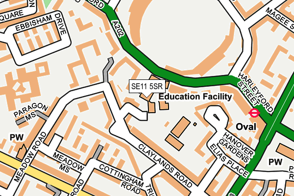
SE11 5SR is located in the Oval electoral ward, within the London borough of Lambeth and the English Parliamentary constituency of Vauxhall. The Sub Integrated Care Board (ICB) Location is NHS South East London ICB - 72Q and the police force is Metropolitan Police. This postcode has been in use since January 1980.


GetTheData
Source: OS OpenMap – Local (Ordnance Survey)
Source: OS VectorMap District (Ordnance Survey)
Licence: Open Government Licence (requires attribution)
| Easting | 530917 |
| Northing | 177631 |
| Latitude | 51.482490 |
| Longitude | -0.116027 |
GetTheData
Source: Open Postcode Geo
Licence: Open Government Licence
| Country | England |
| Postcode District | SE11 |
➜ See where SE11 is on a map ➜ Where is London? | |
GetTheData
Source: Land Registry Price Paid Data
Licence: Open Government Licence
Elevation or altitude of SE11 5SR as distance above sea level:
| Metres | Feet | |
|---|---|---|
| Elevation | 10m | 33ft |
Elevation is measured from the approximate centre of the postcode, to the nearest point on an OS contour line from OS Terrain 50, which has contour spacing of ten vertical metres.
➜ How high above sea level am I? Find the elevation of your current position using your device's GPS.
GetTheData
Source: Open Postcode Elevation
Licence: Open Government Licence
| Ward | Oval |
| Constituency | Vauxhall |
GetTheData
Source: ONS Postcode Database
Licence: Open Government Licence
| Archbishop Tenison's School (Kennington Oval) | Kennington | 78m |
| Archbishop Tenison's School (Kennington Oval) | Kennington | 82m |
| Oval (Harleyford Street) | Oval | 228m |
| Oval (Harleyford Street) | Oval | 236m |
| Oval (Kennington Park Road) | Oval | 243m |
| Oval Underground Station | Oval | 259m |
| Vauxhall Underground Station | Vauxhall | 673m |
| Kennington Underground Station | Kennington | 955m |
| Stockwell Underground Station | Stockwell | 1,235m |
| Pimlico Underground Station | Pimlico | 1,434m |
| Vauxhall Station | 0.6km |
| Elephant & Castle Station | 1.8km |
| Loughborough Junction Station | 2km |
GetTheData
Source: NaPTAN
Licence: Open Government Licence
GetTheData
Source: ONS Postcode Database
Licence: Open Government Licence


➜ Get more ratings from the Food Standards Agency
GetTheData
Source: Food Standards Agency
Licence: FSA terms & conditions
| Last Collection | |||
|---|---|---|---|
| Location | Mon-Fri | Sat | Distance |
| Harleyford Road | 17:30 | 12:00 | 220m |
| Harleyford Road | 17:30 | 12:00 | 222m |
| 10 Clapham Road | 17:30 | 12:00 | 252m |
GetTheData
Source: Dracos
Licence: Creative Commons Attribution-ShareAlike
| Risk of SE11 5SR flooding from rivers and sea | Very Low |
| ➜ SE11 5SR flood map | |
GetTheData
Source: Open Flood Risk by Postcode
Licence: Open Government Licence
The below table lists the International Territorial Level (ITL) codes (formerly Nomenclature of Territorial Units for Statistics (NUTS) codes) and Local Administrative Units (LAU) codes for SE11 5SR:
| ITL 1 Code | Name |
|---|---|
| TLI | London |
| ITL 2 Code | Name |
| TLI4 | Inner London - East |
| ITL 3 Code | Name |
| TLI45 | Lambeth |
| LAU 1 Code | Name |
| E09000022 | Lambeth |
GetTheData
Source: ONS Postcode Directory
Licence: Open Government Licence
The below table lists the Census Output Area (OA), Lower Layer Super Output Area (LSOA), and Middle Layer Super Output Area (MSOA) for SE11 5SR:
| Code | Name | |
|---|---|---|
| OA | E00015636 | |
| LSOA | E01033207 | Lambeth 004F |
| MSOA | E02000621 | Lambeth 004 |
GetTheData
Source: ONS Postcode Directory
Licence: Open Government Licence
| SW8 1NF | Ashmole Street | 43m |
| SW8 1NB | Meadow Road | 44m |
| SW8 1ND | Meadow Road | 44m |
| SW8 1NJ | Claylands Road | 62m |
| SW8 1NZ | Claylands Road | 115m |
| SW8 1PJ | Claylands Road | 117m |
| SW8 1QE | Meadow Road | 128m |
| SW8 1PH | Claylands Road | 136m |
| SW8 1NS | Elias Place | 142m |
| SW8 1LQ | Cottingham Road | 144m |
GetTheData
Source: Open Postcode Geo; Land Registry Price Paid Data
Licence: Open Government Licence